File:1818 Pinkerton Map of the West Indies, Antilles, and Caribbean Sea - Geographicus - WestIndies2-pinkerton-1818.jpg
Перейти к навигации
Перейти к поиску
Размер этого предпросмотра: 800 × 590 пкс. Другие разрешения: 320 × 236 пкс | 640 × 472 пкс | 1024 × 755 пкс | 1280 × 943 пкс | 2560 × 1887 пкс | 5000 × 3685 пкс.
Исходный файл (5000 × 3685 пкс, размер файла: 3,91 МБ, MIME-тип: image/jpeg)
Краткие подписи
Краткие подписи
Добавьте однострочное описание того, что собой представляет этот файл
| Джон Пинкертон: West Indies.
( |
|||||||||||||||||||||
|---|---|---|---|---|---|---|---|---|---|---|---|---|---|---|---|---|---|---|---|---|---|
| Автор |
|
||||||||||||||||||||
| Название |
West Indies. |
||||||||||||||||||||
| Описание |
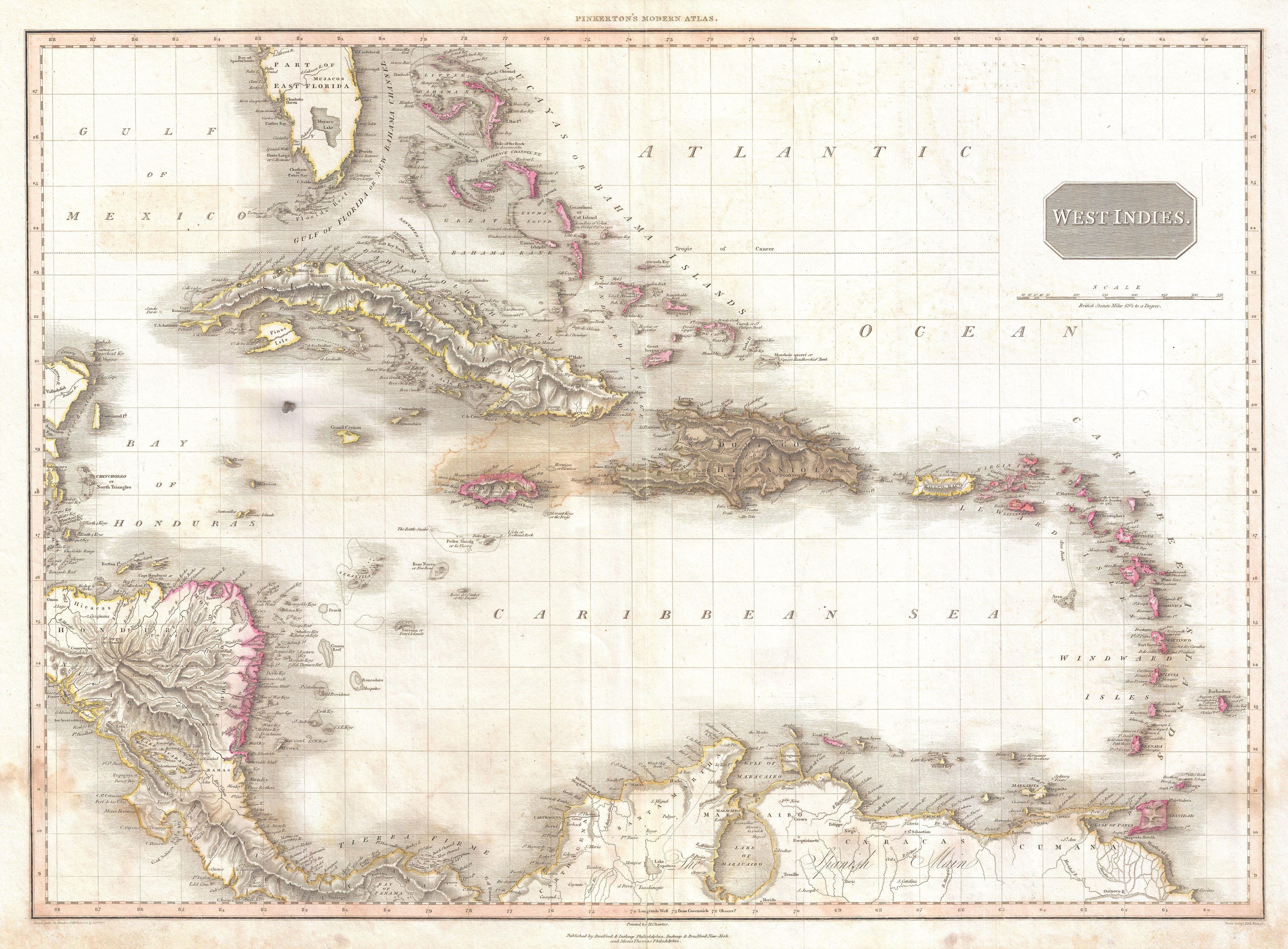
English: Extraordinary large format map of the West Indies published in 1818 by cartographer John Pinkerton. Centered on the island of Hispaniola or Santo Domingo, this map covers from the Bay of Honduras to the Windward Isles, and from Florida and the Bahamas south to Lake Maracaibo and the Spanish Main. Includes Cuba, Jamaica, Porto Rico, Hispaniola, the Bahamas, and southern Florida. In Florida there is a large inland lake, labeled Mayaco, which is no doubt an embryonic representation of Lake Okeechobee. Pinkerton offers extraordinary detail throughout noting both physical and political elements, including shoals, reefs, and other undersea dangers. Possibly the most attractive English map of the West Indies to appear in the early 19th century. Drawn by L. Herbert and engraved by Samuel Neele under the direction of John Pinkerton. The map comes from the scarce American edition of Pinkerton’s Modern Atlas, published by Thomas Dobson & Co. of Philadelphia in 1818. |
||||||||||||||||||||
| Дата | 1818 (undated) | ||||||||||||||||||||
| Размеры | высота: 21 дюймов (53,3 см); ширина: 28 дюймов (71,1 см) | ||||||||||||||||||||
| Инвентарный номер |
Geographicus link: WestIndies2-pinkerton-1818 |
||||||||||||||||||||
| Источник/Фотограф |
Pinkerton, J., A Modern Atlas, from the Lates and Best Authorities, Exhibiting the Various Divisions of the World with its chief Empires, Kingdoms, and States; in Sixty Maps, carefully reduced from the Larges and Most Authentic Sources. 1818, Philadelphia, Thomas Dobson Edition.
|
||||||||||||||||||||
| Права (Повторное использование этого файла) |
|
||||||||||||||||||||

See also
[править]
- Alternative map of early 1800s West Indies:

История файла
Нажмите на дату/время, чтобы увидеть версию файла от того времени.
| Дата/время | Миниатюра | Размеры | Участник | Примечание | |
|---|---|---|---|---|---|
| текущий | 05:26, 23 марта 2011 | | 5000 × 3685 (3,91 МБ) | BotMultichillT (обсуждение | вклад) | {{subst:User:Multichill/Geographicus |link=http://www.geographicus.com/P/AntiqueMap/WestIndies2-pinkerton-1818 |product_name=1818 Pinkerton Map of the West Indies, Antilles, and Caribbean Sea |map_title=West Indies. |description=Extraordinary large format |
Вы не можете перезаписать этот файл.
Использование файла
Следующие 2 страницы используют этот файл:
Глобальное использование файла
Данный файл используется в следующих вики:
- Использование в en.wikipedia.org
- Использование в es.wikipedia.org
- Использование в ja.wikipedia.org
- Использование в ru.wikipedia.org