File:1827 Finley Map of Georgia - Geographicus - Georgia-finley-1827.jpg

Fichier d’origine (2 313 × 3 000 pixels, taille du fichier : 1,78 Mio, type MIME : image/jpeg)
Légendes
Légendes
| Anthony Finley : Georgia.
( |
||||||
|---|---|---|---|---|---|---|
| Artiste | ||||||
| Titre |
Georgia. |
|||||
| Description |
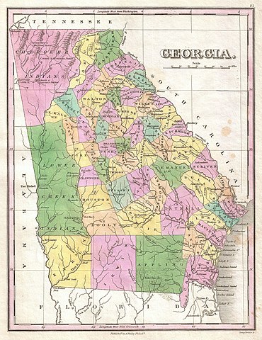
English: A beautiful example of Finley's important 1827 map of Georgia. Depicts the state with moderate detail in Finley's classic minimalist style. Shows river ways, roads, canals, and some topographical features. Offers color coding at the county level. Finley's map of Georgia is particularly interesting and important due to its portrayal of the rapidly changing American Indian situation in the western part of the state. In 1827 a substantial part of northwestern Georgia was a confined territory assigned to the Lower Creek and Cherokee nations. Finley's map details the borders of this country as defined by the Flint and Chestatie Rivers. Also notes numerous American Indian villages and missionary stations, including a Moravian mission, within the Lower Creek and Cherokee territories. Just four years after this map was made the Creek and Cherokee would forcibly relocated westward in the infamous Trail of Tears. Title and scale in lower right quadrant. Engraved by Young and Delleker for the 1827 edition of Anthony Finley's General Atlas . |
|||||
| Date | 1827 (undated) | |||||
| Dimensions | hauteur : 11,5 pouces (29,2 cm) ; largeur : 9 pouces (22,8 cm) | |||||
| Numéro d’inventaire |
liens Geographicus : Georgia-finley-1827 |
|||||
| Source / photographe |
Finley, Anthony, A New General Altas, Comprising a Complete Set of Maps, representing the Grand Divisions of the Globe, Together with the several Empires, Kingdoms and States in the World; Compiled from the Best Authorities, and corrected by the Most Recent Discoveries, Philadelphia, 1827.
|
|||||
| Autorisation (Réutilisation de ce fichier) |
|
|||||
Historique du fichier
Cliquer sur une date et heure pour voir le fichier tel qu'il était à ce moment-là.
| Date et heure | Vignette | Dimensions | Utilisateur | Commentaire | |
|---|---|---|---|---|---|
| actuel | 23 mars 2011 à 08:46 | | 2 313 × 3 000 (1,78 Mio) | BotMultichillT (d | contributions) | {{subst:User:Multichill/Geographicus |link=http://www.geographicus.com/P/AntiqueMap/Georgia-finley-1827 |product_name=1827 Finley Map of Georgia |map_title=Georgia. |description=A beautiful example of Finley's important 1827 map of Georgia. Depicts the s |
Vous ne pouvez pas remplacer ce fichier.
Utilisations locales du fichier
La page suivante utilise ce fichier :
Utilisations du fichier sur d’autres wikis
Les autres wikis suivants utilisent ce fichier :
- Utilisation sur fr.wikinews.org