File:1847 Levasseur Map of Africa - Geographicus - Africa-levasseur-1847.jpg
Jump to navigation
Jump to search
Size of this preview: 800 × 577 pixels. Other resolutions: 320 × 231 pixels | 640 × 462 pixels | 1,024 × 739 pixels | 1,280 × 924 pixels | 2,560 × 1,847 pixels | 4,000 × 2,886 pixels.
Original file (4,000 × 2,886 pixels, file size: 4.01 MB, MIME type: image/jpeg)
Captions
Captions
Add a one-line explanation of what this file represents
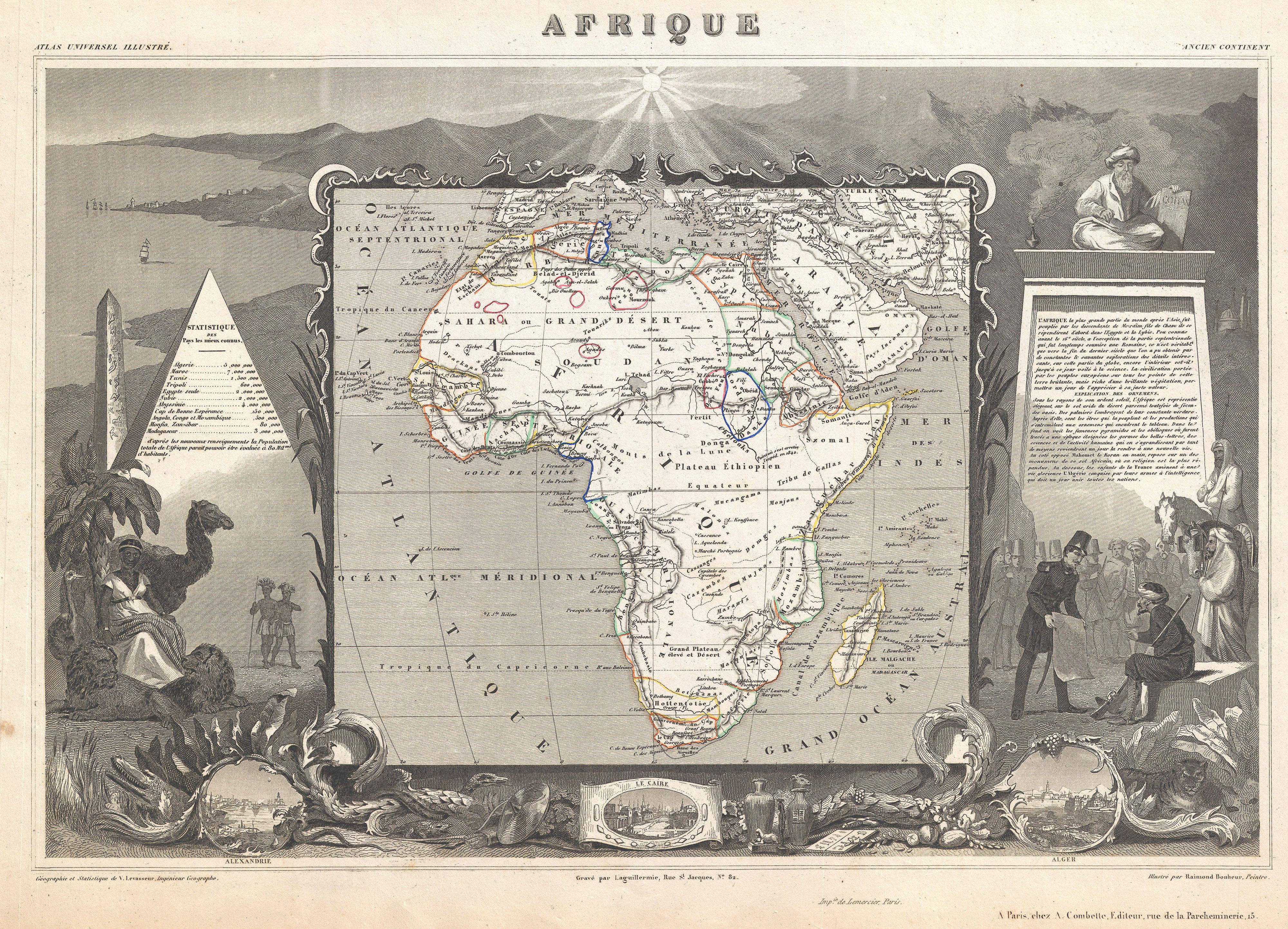
| Afrique. | ||||||||||||||||||||||||||||||||||||
|---|---|---|---|---|---|---|---|---|---|---|---|---|---|---|---|---|---|---|---|---|---|---|---|---|---|---|---|---|---|---|---|---|---|---|---|---|
| Artist |
|
|||||||||||||||||||||||||||||||||||
| Title |
Afrique. |
|||||||||||||||||||||||||||||||||||
| Description |
English: A stunning c. 1847 map of Africa by French cartographer Victor Levasseur. Depicts the entire continent with several interesting elements. A large lake appears in Mozambique which can only be Lake Malawi (Lake Nyasa). Lake Chad (Tchad) is also shown. Names numerous African kingdoms including Monomotapa and the Hottentots. Surrounded by the elaborate borders for which Levasseur is best known. Shows a stylized pyramid and obelisk, an imam, a French soldier consulting with Arabs, and three city vies: Alexandria, Cairo and Algiers. Prepared and published for V. Levasseur's magnificent c. 1847 Atlas Universel Illustre , one of the last decorative atlases of the 19th century. |
|||||||||||||||||||||||||||||||||||
| Date | circa 1847(undated) | |||||||||||||||||||||||||||||||||||
| Dimensions | height: 12.5 in (31.7 cm); width: 18 in (45.7 cm) | |||||||||||||||||||||||||||||||||||
| Accession number |
Geographicus link: Africa-levasseur-1847 |
|||||||||||||||||||||||||||||||||||
| Source/Photographer |
Levasseur, V., Atlas Universel Illustre, c. 1847.
|
|||||||||||||||||||||||||||||||||||
| Permission (Reusing this file) |
|
|||||||||||||||||||||||||||||||||||
File history
Click on a date/time to view the file as it appeared at that time.
| Date/Time | Thumbnail | Dimensions | User | Comment | |
|---|---|---|---|---|---|
| current | 22:59, 22 March 2011 | | 4,000 × 2,886 (4.01 MB) | BotMultichillT (talk | contribs) | {{subst:User:Multichill/Geographicus |link=http://www.geographicus.com/P/AntiqueMap/Africa-levasseur-1847 |product_name=1847 Levasseur Map of Africa |map_title=Afrique. |description=A stunning c. 1847 map of Africa by French cartographer Victor Levasseur. |
You cannot overwrite this file.
File usage on Commons
The following page uses this file:
File usage on other wikis
The following other wikis use this file:
- Usage on ja.wikipedia.org
- Usage on www.wikidata.org