File:1852 Levasseur Map of the Department De La Charente Maritime - Geographicus - CharenteInf-levasseur-1852.jpg
Перейти к навигации
Перейти к поиску
Размер этого предпросмотра: 415 × 599 пкс. Другие разрешения: 166 × 240 пкс | 333 × 480 пкс | 532 × 768 пкс | 710 × 1024 пкс | 2426 × 3500 пкс.
Исходный файл (2426 × 3500 пкс, размер файла: 2,92 МБ, MIME-тип: image/jpeg)
Краткие подписи
Краткие подписи
Добавьте однострочное описание того, что собой представляет этот файл
| Dept. de la Charente Infre. | ||||||||||||||||||||||||||||||||||||
|---|---|---|---|---|---|---|---|---|---|---|---|---|---|---|---|---|---|---|---|---|---|---|---|---|---|---|---|---|---|---|---|---|---|---|---|---|
| Автор |
|
|||||||||||||||||||||||||||||||||||
| Название |
Dept. de la Charente Infre. |
|||||||||||||||||||||||||||||||||||
| Описание |
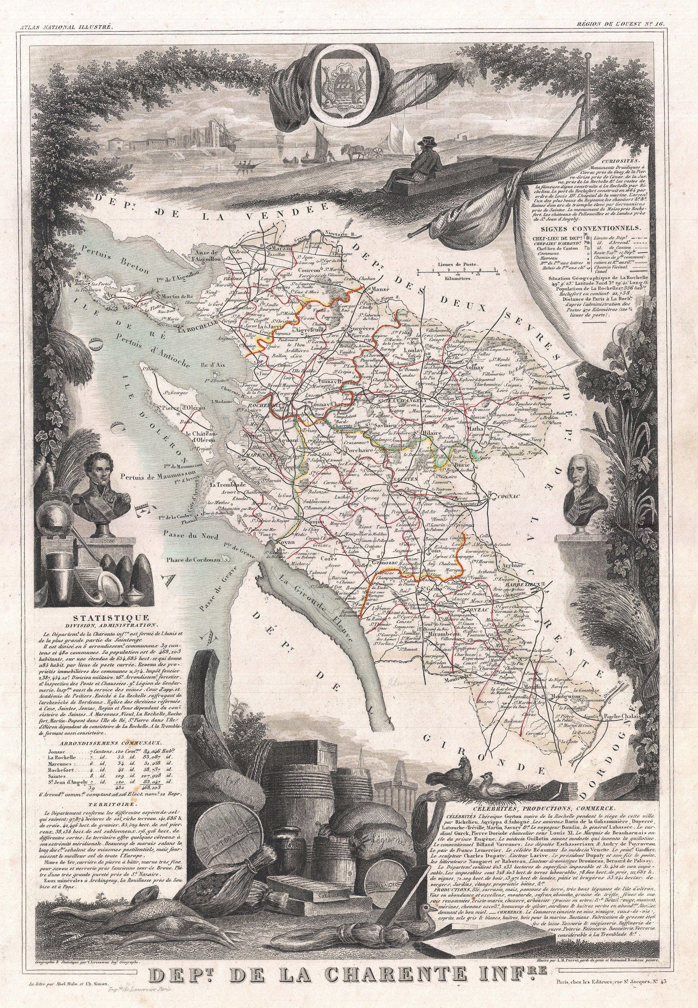
English: This is a fascinating 1852 map of the French department of Charente Inférieure (Charente Maritime), France. Charente Maritime is a coastal province border Charente, Dordogne, and Gironde (Bordeaux). It is best known as the producer of the world's finest Cognacs. The map proper is surrounded by elaborate decorative engravings designed to illustrate both the natural beauty and trade richness of the land. There is a short textual history of the regions depicted on both the left and right sides of the map. Published by V. Levasseur in the 1852 edition of his Atlas National de la France Illustree.
Français : Il s'agit d'une carte de 1852 du département français de la Charente-Inférieure (ancien nom de la Charente-Maritime). La Charente-Maritime est un département côtier. Il est surtout connu comme le producteur des meilleurs cognacs, au monde. La carte est décorée de gravures qui illustrent la beauté et la richesse naturelle du commerce de la terre. Il y a une courte histoire textuelle des régions représentées sur les côtés gauche et droit de la carte. Publiée par Victor Levasseur dans l'édition 1852 de son Atlas National Illustré de France. |
|||||||||||||||||||||||||||||||||||
| Дата | 1852 | |||||||||||||||||||||||||||||||||||
| Размеры | высота: 17 дюймов (43,1 см); ширина: 11,5 дюймов (29,2 см) | |||||||||||||||||||||||||||||||||||
| Инвентарный номер |
Geographicus link: CharenteInf-levasseur-1852 |
|||||||||||||||||||||||||||||||||||
| Источник/Фотограф |
Levassuer, V., Atlas National Illustre des 86 Departements et des Possessions de La France Divise par Arrondissements, Cantons et Communea avec La Trace de Toutes Les Routes, Chemins,de fer et Canaux., 1852 edition.
|
|||||||||||||||||||||||||||||||||||
| Права (Повторное использование этого файла) |
|
|||||||||||||||||||||||||||||||||||
История файла
Нажмите на дату/время, чтобы увидеть версию файла от того времени.
| Дата/время | Миниатюра | Размеры | Участник | Примечание | |
|---|---|---|---|---|---|
| текущий | 16:47, 24 марта 2011 | | 2426 × 3500 (2,92 МБ) | BotMultichillT (обсуждение | вклад) | {{subst:User:Multichill/Geographicus |link=http://www.geographicus.com/P/AntiqueMap/CharenteInf-levasseur-1852 |product_name=1852 Levasseur Map of the Department De La Charente Maritime |map_title=Dept. de la Charente Infre. |description=This is a fascina |
Вы не можете перезаписать этот файл.
Использование файла
Следующая страница использует этот файл:
Глобальное использование файла
Данный файл используется в следующих вики:
- Использование в fr.wikipedia.org