File:1852 Shields Wall Map of Boston and Vicinity - Geographicus - Boston-shields-1852.jpg

Original file (2,008 × 1,926 pixels, file size: 511 KB, MIME type: image/jpeg)
Captions
Captions
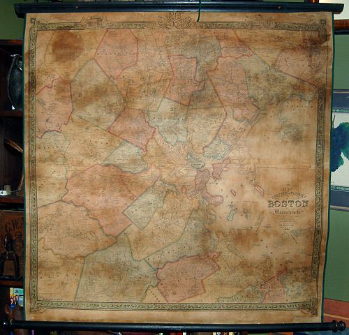
| Map of the City and Vicinity of Boston, Massachusetts. | ||||||
|---|---|---|---|---|---|---|
| Artist | ||||||
| Title |
Map of the City and Vicinity of Boston, Massachusetts. |
|||||
| Description |
English: An extremely scarce and dramatic 1852 wall map of Boston, Massachusetts and vicinity. Depicts the greater Boston area from Dover in the southwest to part of Concord in the northwest to Hingham southeast and to Danvers northeast. Includes all of Brookline, Newton and Waltham and much of Weston and Needham. The names of various families and landholders are indicated throughout with the exception of Boston proper. Based upon original surveys by F.G. Sidney. Highly decorative green border features engraved views of the Boston State House and Faneuil Hall. Full restoration. Original rollers. |
|||||
| Date | 1852 (dated) | |||||
| Dimensions | height: 40 in (101.6 cm); width: 41 in (104.1 cm) | |||||
| Accession number |
Geographicus link: Boston-shields-1852 |
|||||
| Source/Photographer |
|
|||||
| Permission (Reusing this file) |
|
|||||
File history
Click on a date/time to view the file as it appeared at that time.
| Date/Time | Thumbnail | Dimensions | User | Comment | |
|---|---|---|---|---|---|
| current | 06:49, 24 March 2011 | | 2,008 × 1,926 (511 KB) | BotMultichillT (talk | contribs) | {{subst:User:Multichill/Geographicus |link=http://www.geographicus.com/P/AntiqueMap/Boston-shields-1852 |product_name=1852 Shields Wall Map of Boston and Vicinity |map_title=Map of the City and Vicinity of Boston, Massachusetts. |description=An extremely |
You cannot overwrite this file.
File usage on Commons
The following page uses this file: