File:1862 Johnson Map of Central America - Geographicus - CentralAmerica-johnson-1862.jpg
Ir a la navegación
Ir a la búsqueda

Tamaño de esta previsualización: 750 × 599 píxeles. Otras resoluciones: 301 × 240 píxeles | 601 × 480 píxeles | 961 × 768 píxeles | 1280 × 1023 píxeles | 2560 × 2045 píxeles | 4000 × 3196 píxeles.
Archivo original (4000 × 3196 píxeles; tamaño de archivo: 4,71 MB; tipo MIME: image/jpeg)
Leyendas
Leyendas
Añade una explicación corta acerca de lo que representa este archivo
| Alvin Jewett Johnson: Johnson's Central America.
( |
|||||||||||||||||||||||
|---|---|---|---|---|---|---|---|---|---|---|---|---|---|---|---|---|---|---|---|---|---|---|---|
| Artista |
|
||||||||||||||||||||||
| Título |
Johnson's Central America. |
||||||||||||||||||||||
| Descripción |
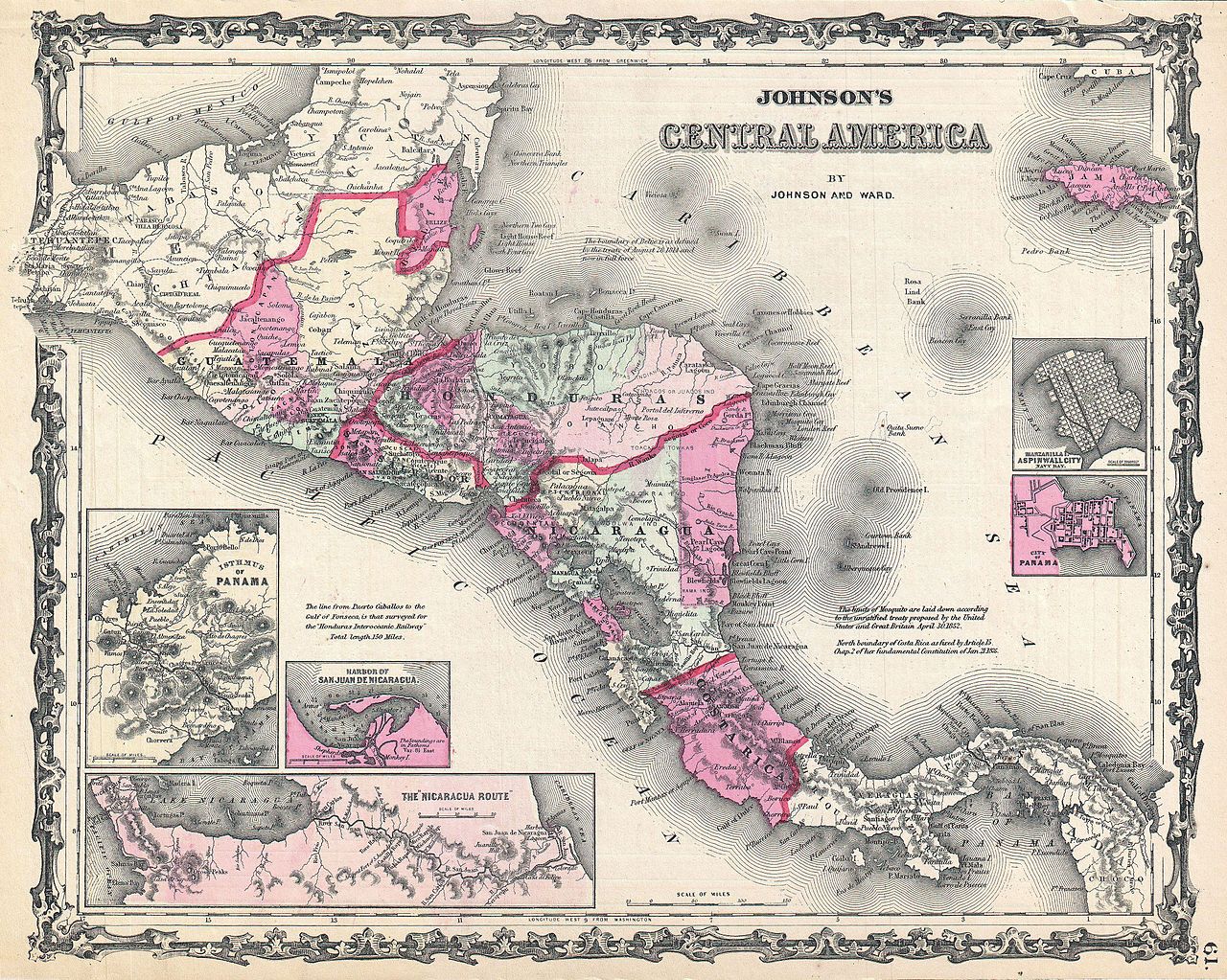
English: This is A. J. Johnson and Ward’s 1862 map of Central America. Covers Central America from the Isthmus of Tehuantepec, Mexico to the Bay of Panama. Shows the countries of Guatemala, Honduras, El Salvador, Nicaragua, and Costa Rica. Jamaica appears in the upper right corner. Shows proposed roadways, cities, rivers, and ferry crossings. The lower left hand quadrant features three inset maps. In a clockwise fashion from top left these detail the Isthmus of Panama, the Nicaragua Route to the Pacific, and the Harbor of San Juan de Nicaragua. Two additional insets on the right hand side of the map show Aspinwall City and the City of Panama. Features the strapwork border common to Johnson’s atlas work from 1860 to 1863. Based on a similar 1855 map by J. H. Colton. Steel plate engraving prepared by A. J. Johnson for publication as page no. 61 in the 1862 edition of his New Illustrated Atlas… This is the first edition of the Johnson’s Atlas to bear the Johnson and Ward imprint. |
||||||||||||||||||||||
| Fecha | 1862 (undated) | ||||||||||||||||||||||
| Dimensiones | altura: 12,5 in (31,7 cm); ancho: 15,5 in (39,3 cm) | ||||||||||||||||||||||
| Número de inventario |
Geographicus link: CentralAmerica-johnson-1862 |
||||||||||||||||||||||
| Fuente/fotógrafo |
Johnson, A. J., Johnson's New Illustrated Family Atlas. (1862 A. J. Johnson & Ward edition)
|
||||||||||||||||||||||
| Permiso (Reutilización de este archivo) |
|
||||||||||||||||||||||
Historial del archivo
Haz clic sobre una fecha y hora para ver el archivo tal como apareció en ese momento.
| Fecha y hora | Miniatura | Dimensiones | Usuario | Comentario | |
|---|---|---|---|---|---|
| actual | 17:18 22 mar 2011 | | 4000 × 3196 (4,71 MB) | BotMultichillT (discusión | contribs.) | {{subst:User:Multichill/Geographicus |link=http://www.geographicus.com/P/AntiqueMap/CentralAmerica-johnson-1862 |product_name=1862 Johnson Map of Central America |map_title=Johnson's Central America. |description=This is A. J. Johnson and Ward’s 1862 ma |
No puedes sobrescribir este archivo.
Usos del archivo
La siguiente página usa este archivo:
Uso global del archivo
Las wikis siguientes utilizan este archivo:
- Uso en es.wikipedia.org