File:1862 Johnson Map of the World on Mercator Projection - Geographicus - WorldMerc-johnson-1862.jpg
Jump to navigation
Jump to search
Size of this preview: 800 × 537 pixels. Other resolutions: 320 × 215 pixels | 640 × 429 pixels | 1,024 × 687 pixels | 1,280 × 859 pixels | 2,560 × 1,717 pixels | 5,000 × 3,354 pixels.
Original file (5,000 × 3,354 pixels, file size: 5.95 MB, MIME type: image/jpeg)
Captions
Captions
Add a one-line explanation of what this file represents
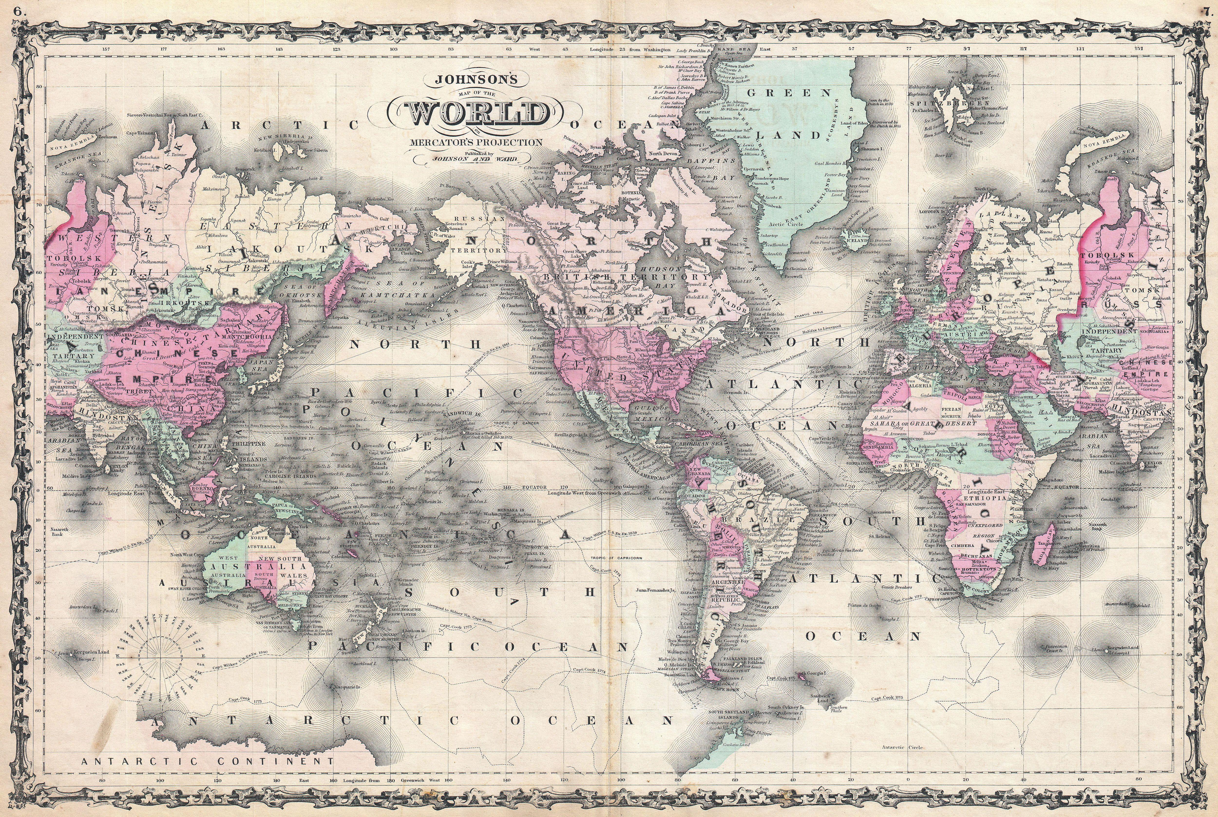
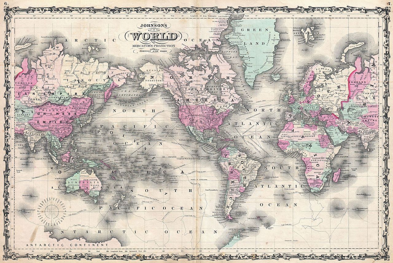
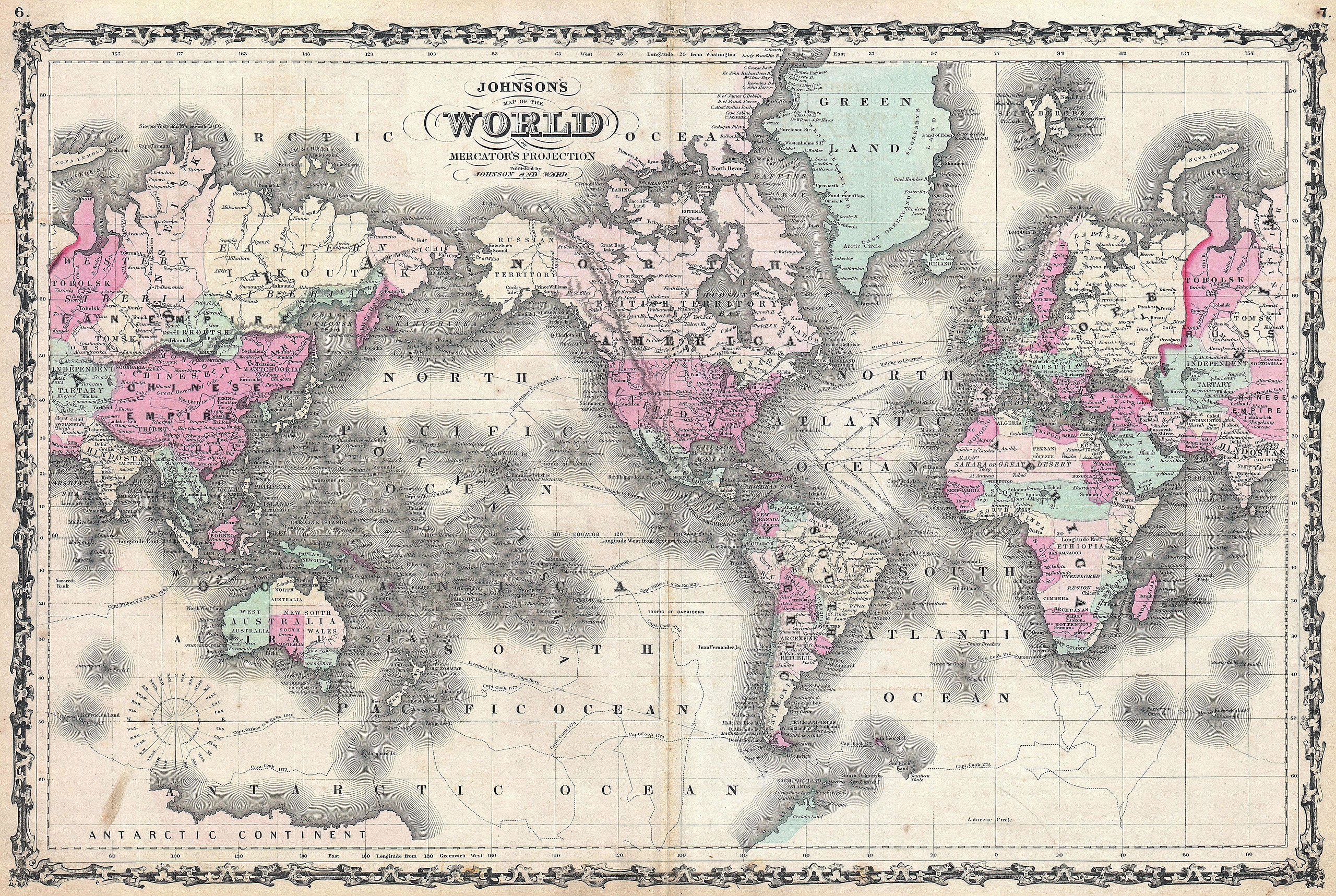
| Alvin Jewett Johnson: Johnson's Map of the World on Mercator's Projection.
( |
|||||||||||||||||||||||
|---|---|---|---|---|---|---|---|---|---|---|---|---|---|---|---|---|---|---|---|---|---|---|---|
| Artist |
|
||||||||||||||||||||||
| Title |
Johnson's Map of the World on Mercator's Projection. |
||||||||||||||||||||||
| Description |
English: This is A. J. Johnson’s fine 1862 map of the world on Mercator’s Projection. Depicts the entire world centered on North and South America. Offers a fascinating snapshot of the world during a period of rapid globalization and discovery. Africa is largely “unexplored” and both Lake Victoria and Lake Tanganyika have yet to appear. The Antarctic continent is shown only sketchily, representing the relatively primitive state of Antarctic exploration in 1862. Shows the path of important explorers including Cook and Wilkes. Also notes several ship routes between America and Europe as well as the path of the Atlantic Telegraph Cable. Features the strapwork style border common to Johnson’s atlas work from 1860 to 1863. Prepared by A. J. Johnson and Ward for publication as plates no. 6 and 7 in the 1862 edition of the New Illustrated Atlas… . |
||||||||||||||||||||||
| Date | 1862 (undated) | ||||||||||||||||||||||
| Dimensions | height: 17 in (43.1 cm); width: 25 in (63.5 cm) | ||||||||||||||||||||||
| Accession number |
Geographicus link: WorldMerc-johnson-1862 |
||||||||||||||||||||||
| Source/Photographer |
Johnson, A. J., Johnson's New Illustrated (Steel Plate) Family Atlas with Descriptions, Geographical, Statistical, and Historical. (1862 A. J. Johnson & Ward edition)
|
||||||||||||||||||||||
| Permission (Reusing this file) |
|
||||||||||||||||||||||
| Other versions | |||||||||||||||||||||||
File history
Click on a date/time to view the file as it appeared at that time.
| Date/Time | Thumbnail | Dimensions | User | Comment | |
|---|---|---|---|---|---|
| current | 19:42, 22 March 2011 | | 5,000 × 3,354 (5.95 MB) | BotMultichillT (talk | contribs) | {{subst:User:Multichill/Geographicus |link=http://www.geographicus.com/P/AntiqueMap/WorldMerc-johnson-1862 |product_name=1862 Johnson Map of the World on Mercator Projection |map_title=Johnson's Map of the World on Mercator's Projection. |description=This |
You cannot overwrite this file.
File usage on Commons
The following 2 pages use this file: