File:1864 Johnson's Map of India (Hindostan or British India) - Geographicus - India-j-64.jpg
跳至導覽
跳至搜尋

預覽大小:753 × 599 像素。 其他解析度:302 × 240 像素 | 603 × 480 像素 | 965 × 768 像素 | 1,280 × 1,019 像素 | 2,500 × 1,990 像素。
原始檔案 (2,500 × 1,990 像素,檔案大小:1.63 MB,MIME 類型:image/jpeg)
說明
說明
添加單行說明來描述出檔案所代表的內容
map shows name as hindostan
| Alvin Jewett Johnson:Johnson’s Hindostan or British India.
( |
|||||||||||||||||||||||
|---|---|---|---|---|---|---|---|---|---|---|---|---|---|---|---|---|---|---|---|---|---|---|---|
| 作家 |
|
||||||||||||||||||||||
| 標題 |
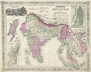
Johnson’s Hindostan or British India. |
||||||||||||||||||||||
| 描述 |
English: A very nice example of A. J. Johnson’s 1864 map of India and Southeast Asia. Covers from the Indus River eastward to include all of India, Burma, Siam (Thailand), Laos, Cambodia, Malaysia (Malacca) and Vietnam (Tonquin and Chochin). Also includes parts of Pakistan, Nepal, China, Bhutan, Sumatra and Ceylon (Sri Lanka). Offers color coding according to country and region as well as notations regarding roadways, cities, towns, and river systems. Three inset maps focus on the Island of Bombay (Mumbai), Madras, and Calcutta. An view of the Government House and Treasury in Calcutta adorns the upper left corner. Features the fretwork style border common to Johnson’s atlas work from 1864 to 1869. Published by A. J. Johnson and Ward as plate number 95 in the 1864 edition of Johnson’s New Illustrated Family Atlas. This is the last edition of the Johnson Atlas to bear the Johnson and Ward imprint, subsequent editions were attributed to Johnson exclusively. |
||||||||||||||||||||||
| 日期 | 1864年 (undated) | ||||||||||||||||||||||
| 尺寸 | 高度:13英寸(33釐米);寬度:17英寸(43.1釐米) | ||||||||||||||||||||||
| 登錄號 |
Geographicus link: India-j-64 |
||||||||||||||||||||||
| 來源/攝影者 |
Johnson, A. J., Johnson's New Illustrated Family Atlas of The World with Physical Geography, and with Descriptions Geographical, Statistical, and Historic including The Latest Federal Census, A Geographical Index, and a Chronological History of the Civil War in America, 1864.
|
||||||||||||||||||||||
| 授權許可 (重用此檔案) |
|
||||||||||||||||||||||
檔案歷史
點選日期/時間以檢視該時間的檔案版本。
| 日期/時間 | 縮圖 | 尺寸 | 用戶 | 備註 | |
|---|---|---|---|---|---|
| 目前 | 2011年3月16日 (三) 09:44 | | 2,500 × 1,990(1.63 MB) | BotMultichill(對話 | 貢獻) | {{subst:User:Multichill/Geographicus |link=http://www.geographicus.com/P/AntiqueMap/India-j-64 |product_name=1864 Johnson's Map of India (Hindostan or British India) |map_title=Johnson’s Hindostan or British India. |description=A very nice example of A. |
無法覆蓋此檔案。
檔案用途
下列頁面有用到此檔案:
_-_Geographicus_-_India-j-64.jpg)
全域檔案使用狀況
以下其他 wiki 使用了這個檔案:
- ar.wikipedia.org 的使用狀況
- azb.wikipedia.org 的使用狀況
- en.wikipedia.org 的使用狀況
- fa.wikipedia.org 的使用狀況
- incubator.wikimedia.org 的使用狀況
- it.wikipedia.org 的使用狀況
- ml.wikipedia.org 的使用狀況
- nl.wikipedia.org 的使用狀況
- ps.wikipedia.org 的使用狀況
- ru.wiktionary.org 的使用狀況
- sd.wikipedia.org 的使用狀況
- simple.wikipedia.org 的使用狀況
- skr.wikipedia.org 的使用狀況
- sr.wikipedia.org 的使用狀況
- ta.wikipedia.org 的使用狀況
- th.wikipedia.org 的使用狀況
- ur.wikipedia.org 的使用狀況
- zh.wikipedia.org 的使用狀況
_-_Geographicus_-_India-j-64.jpg&oldid=829057992)