File:1864 Mitchell Map of India, Tibet, China and Southeast Asia - Geographicus - India-mitchell-1864.jpg
跳至導覽
跳至搜尋

預覽大小:737 × 600 像素。 其他解析度:295 × 240 像素 | 590 × 480 像素 | 944 × 768 像素 | 1,259 × 1,024 像素 | 2,518 × 2,048 像素 | 4,000 × 3,254 像素。
原始檔案 (4,000 × 3,254 像素,檔案大小:2.79 MB,MIME 類型:image/jpeg)
說明
說明
添加單行說明來描述出檔案所代表的內容
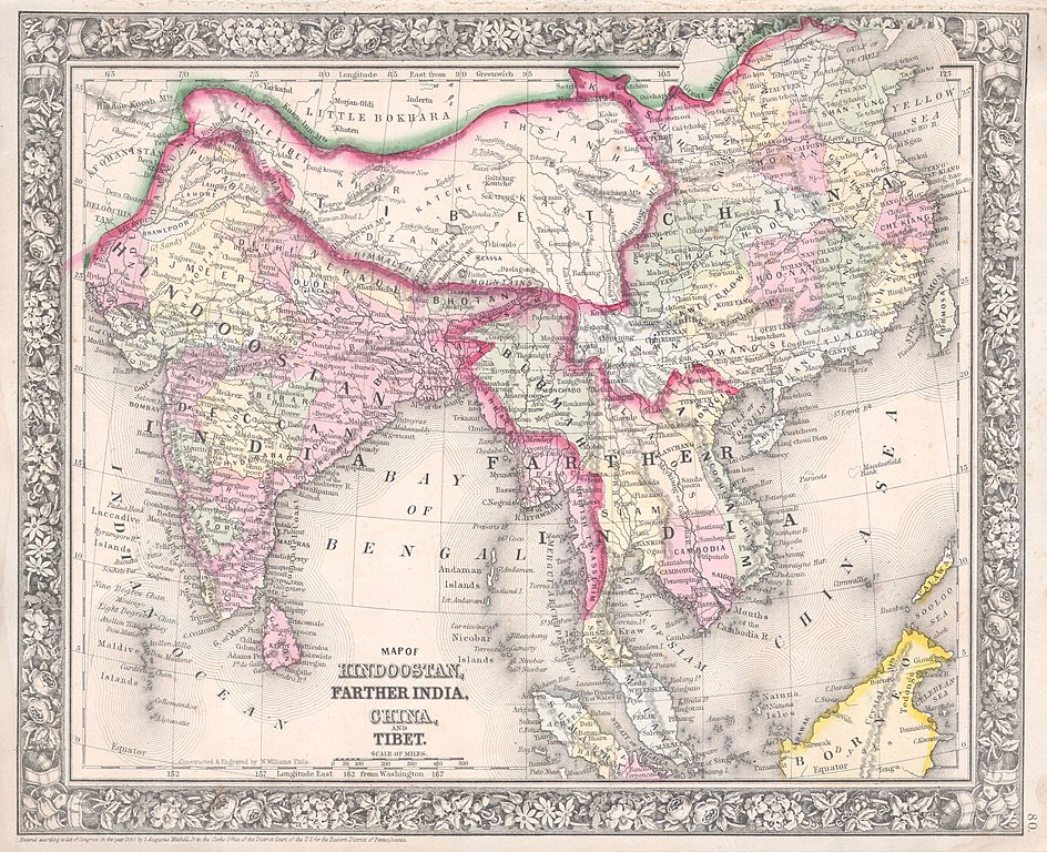
| 塞繆爾·奧古斯都·米切爾:Map of Hindoostan, Farther India, China, and Tibet.
( |
||||||
|---|---|---|---|---|---|---|
| 作家 | ||||||
| 標題 |
Map of Hindoostan, Farther India, China, and Tibet. |
|||||
| 描述 |
English: A beautiful example of S. A. Mitchell Jr.’s 1864 map of the India, Tibet, China and Southeast Asia, including Burma, Thailand, Cambodia, and Vietnam. Covers the region in considerable detail with parts of Malaysia, Sumatra, and Borneo included. One of the most attractive American atlas maps of this region to appear in the mid 19th century. Features the floral border typical of Mitchell maps from the 1860-65 period. Prepared by W. Williams for inclusion as plate 80 in the 1864 issue of Mitchell’s New General Atlas . Dated and copyrighted, “Entered according to Act of Congress in the Year 1860 by S. Augustus Mitchell in the Clerk’s Office of the District Court of the U.S. for the Eastern District of Pennsylvania. |
|||||
| 日期 | 1860年 (dated) | |||||
| 尺寸 | 高度:11.5英寸(29.2公分);寬度:13.7英寸(34.9公分) | |||||
| 登錄號 |
Geographicus link: India-mitchell-1864 |
|||||
| 來源/攝影者 |
Mitchell's New General Atlas, containing Maps of the Various Countries of the World, Plans of Cities, Etc., Embraced in Fifty-three Quarto Maps, forming a series of Eighty-Four Map and Plans, together with Valuable Statistical Tables. (1864 Edition)
|
|||||
| 授權許可 (重用此檔案) |
|
|||||
| 其他版本 | ||||||
.jpg)
檔案歷史
點選日期/時間以檢視該時間的檔案版本。
| 日期/時間 | 縮圖 | 尺寸 | 使用者 | 備註 | |
|---|---|---|---|---|---|
| 目前 | 2011年3月16日 (三) 14:17 | | 4,000 × 3,254(2.79 MB) | BotMultichill(留言 | 貢獻) | {{subst:User:Multichill/Geographicus |link=http://www.geographicus.com/P/AntiqueMap/India-mitchell-1864 |product_name=1864 Mitchell Map of India, Tibet, China and Southeast Asia |map_title=Map of Hindoostan, Farther India, China, and Tibet. |description=A |
無法覆蓋此檔案。
檔案用途
下列3個頁面有用到此檔案:
全域檔案使用狀況
以下其他 wiki 使用了這個檔案:
- ca.wikipedia.org 的使用狀況
- en.wikipedia.org 的使用狀況
- en.wiktionary.org 的使用狀況
- fr.wikipedia.org 的使用狀況
- hi.wikipedia.org 的使用狀況
- id.wikipedia.org 的使用狀況
- it.wikipedia.org 的使用狀況
- ms.wikipedia.org 的使用狀況
- nl.wikipedia.org 的使用狀況
- pt.wikipedia.org 的使用狀況
- sh.wikipedia.org 的使用狀況
- te.wikipedia.org 的使用狀況
- zh.wikipedia.org 的使用狀況