File:1865 Johnson Map of China ^ Taiwan - Geographicus - China-j-64.jpg
Aller à la navigation
Aller à la recherche

Taille de cet aperçu : 729 × 599 pixels. Autres résolutions : 292 × 240 pixels | 584 × 480 pixels | 934 × 768 pixels | 1 245 × 1 024 pixels | 2 491 × 2 048 pixels | 3 000 × 2 467 pixels.
Fichier d’origine (3 000 × 2 467 pixels, taille du fichier : 2,17 Mio, type MIME : image/jpeg)
Légendes
Légendes
Ajoutez en une ligne la description de ce que représente ce fichier
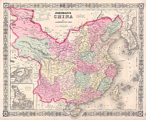
| Alvin Jewett Johnson : Johnson’s China.
( |
|||||||||||||||||||||||
|---|---|---|---|---|---|---|---|---|---|---|---|---|---|---|---|---|---|---|---|---|---|---|---|
| Artiste |
|
||||||||||||||||||||||
| Titre |
Johnson’s China. |
||||||||||||||||||||||
| Description |
English: This is A. J. Johnson’s 1865 map of China. Covers the region with particular attention to cities and waterways. China at the time this map was made was mostly closed country, however, a few ports were opened to western trade, these are noted in capital letters and include Tanchau, Kaifung, Waingan, Shanghai, Canton and Nanking (Nanjing) among others. Insets detail the “Island of Amoy” and Canton (Hong Kong). Features the Celtic style border common to Johnson’s atlas work from 1863 to 1869. Steel plate engraving prepared by A. J. Johnson for publication as plate no. 97 in the 1865 edition of his New Illustrated Atlas… This is the first edition of the Johnson’s Atlas to exclusively bear the A. J. Johnson imprint. |
||||||||||||||||||||||
| Date | 1865 (undated) | ||||||||||||||||||||||
| Dimensions | hauteur : 13 pouces (33 cm) ; largeur : 16 pouces (40,6 cm) | ||||||||||||||||||||||
| Numéro d’inventaire |
liens Geographicus : China-j-64 |
||||||||||||||||||||||
| Source / photographe |
Johnson's New Illustrated Family Atlas, (1865 Johnson and Ward edition).
|
||||||||||||||||||||||
| Autorisation (Réutilisation de ce fichier) |
|
||||||||||||||||||||||
Historique du fichier
Cliquer sur une date et heure pour voir le fichier tel qu'il était à ce moment-là.
| Date et heure | Vignette | Dimensions | Utilisateur | Commentaire | |
|---|---|---|---|---|---|
| actuel | 16 mars 2011 à 09:42 | | 3 000 × 2 467 (2,17 Mio) | BotMultichill (d | contributions) | {{subst:User:Multichill/Geographicus |link=http://www.geographicus.com/P/AntiqueMap/China-j-64 |product_name=1865 Johnson Map of China & Taiwan |map_title=Johnson’s China. |description=This is A. J. Johnson’s 1865 map of China. Covers the region with |
Vous ne pouvez pas remplacer ce fichier.
Utilisations locales du fichier
La page suivante utilise ce fichier :
Utilisations du fichier sur d’autres wikis
Les autres wikis suivants utilisent ce fichier :
- Utilisation sur en.wikipedia.org
- Utilisation sur ru.wikipedia.org