File:1865 Spruner Map Israel or Palestine post 70 AD.jpg
跳至導覽
跳至搜尋
預覽大小:372 × 599 像素。 其他解析度:149 × 240 像素 | 298 × 480 像素 | 476 × 768 像素 | 635 × 1,024 像素 | 1,353 × 2,180 像素。
原始檔案 (1,353 × 2,180 像素,檔案大小:1.39 MB,MIME 類型:image/jpeg)
說明
說明
添加單行說明來描述出檔案所代表的內容
摘要
[編輯]
| 作者 |
|
||
| 描述 |
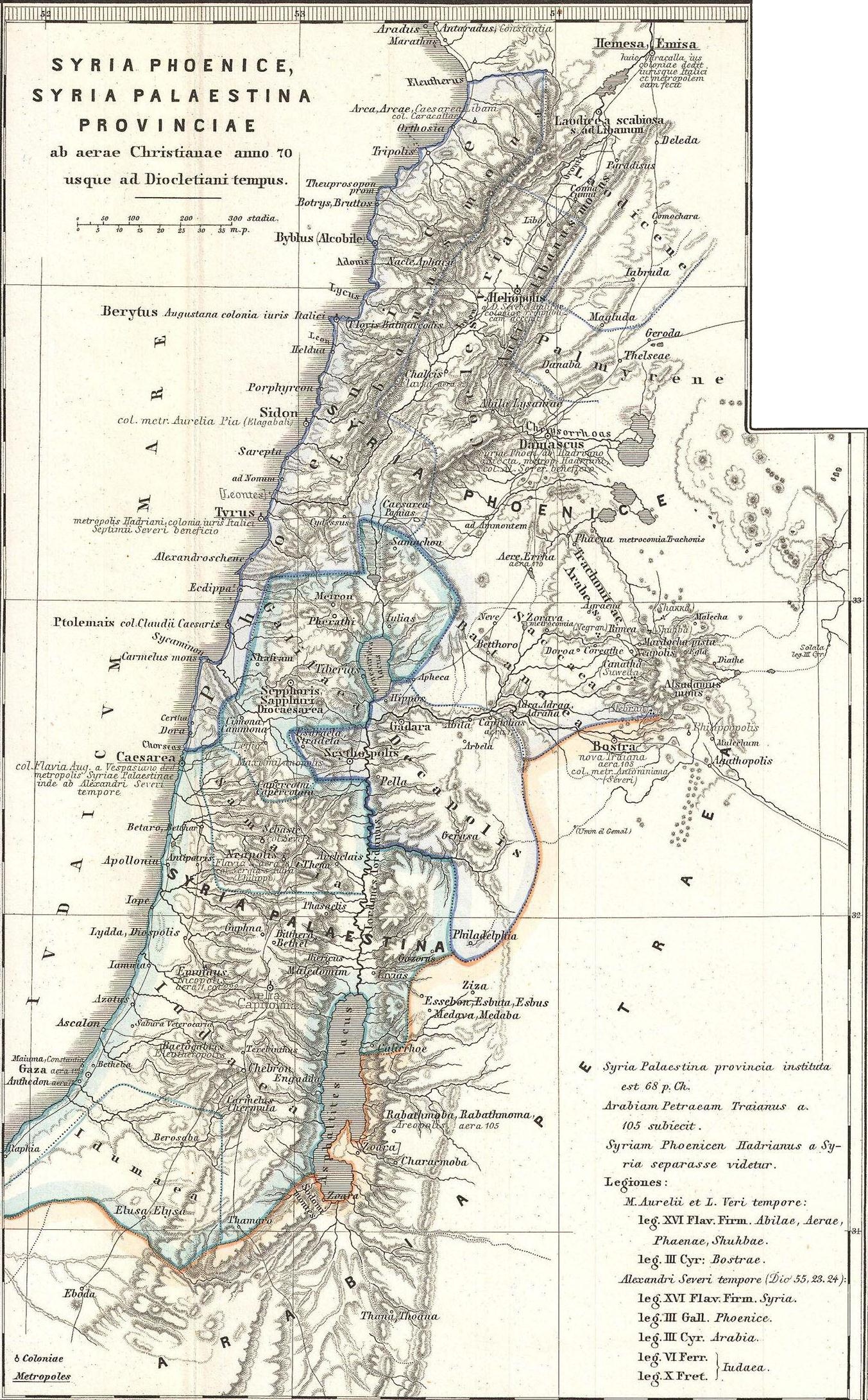
English: This is Karl von Spruner’s 1865 map of the Holy Land, or Israel and Palestine. Essentially nine maps in one, Spruner features two dominant maps and 7 smaller insets, including a Peutinger Table in the lower-right quadrant. The Peutinger Map is an astoundingly important discovery and is today’s only known example of a Roman world map, though the original Peutinger was itself a mediaeval copy of the Roman original. This map also shows, in counter-clock wise order from the Peutinger table, Galilaea, Hierosolyma, Judaea, Palestine at the time of Herod, Syria, Arabia, and Phoeniciae, Palestine, and Arabia. Many of the insets include their own scale or legend. Map notes important cities, rivers, mountain ranges and other minor topographical detail. Territories and countries outlined in color. The whole is rendered in finely engraved detail exhibiting throughout the fine craftsmanship of the Perthes firm. |
||
| 日期 | 1865年 (undated) | ||
| 尺寸 | 高度:16英寸(40.6公分);寬度:13英寸(33公分) | ||
| 登錄號 |
Geographicus link: Phoenice-spruner-1865 |
||
| 來源/攝影者 |
本檔案衍生自: 1865 Spruner Map of the Holy Land, Israel, or Palestine in Antiquity - Geographicus - Phoenice-spruner-1865.jpg: |
| 這是一張修飾過的圖片,即本圖片是用軟體修改過後的版本,修改的方式或內容有:Map divided into 2/3 parts (maps)。原版圖片來源:1865 Spruner Map of the Holy Land, Israel, or Palestine in Antiquity - Geographicus - Phoenice-spruner-1865.jpg。修改者:Cristiano64。
|
授權條款
[編輯]
|
此為如實地拍攝平面藝術品的相片複製本。原作位於公有領域,是因下列原因:
維基媒體基金會的官方立場認為:「針對平面公有領域的藝術作品進行忠實重製,其重製後的照片也屬於公有領域。」
因此,可認定本重製照片屬於公有領域。在其他司法管轄區,再利用此照片可能會被限制;參見再利用PD-Art照片以獲得進一步資訊。 | ||||
原始上傳日誌
[編輯]
This image is a derivative work of the following images:
- File:1865_Spruner_Map_of_the_Holy_Land,_Israel,_or_Palestine_in_Antiquity_-_Geographicus_-_Phoenice-spruner-1865.jpg licensed with PD-Art
- 2011-03-25T05:57:05Z BotMultichillT 3500x2897 (2712725 Bytes) {{subst:User:Multichill/Geographicus |link=http://www.geographicus.com/P/AntiqueMap/Phoenice-spruner-1865 |product_name=1865 Spruner Map of the Holy Land, Israel, or Palestine in Antiquity |map_title=Phoenice, Coelesyria, Dec
Uploaded with derivativeFX
檔案歷史
點選日期/時間以檢視該時間的檔案版本。
| 日期/時間 | 縮圖 | 尺寸 | 使用者 | 備註 | |
|---|---|---|---|---|---|
| 目前 | 2013年1月10日 (四) 08:29 | | 1,353 × 2,180(1.39 MB) | Cristiano64(留言 | 貢獻) | == {{int:filedesc}} == {{Information |Description={{en|This is Karl von Spruner’s 1865 map of the Holy Land, or Israel and Palestine. Essentially nine maps in one, Spruner features two dominant maps and 7 smaller insets, including a Peutinger Table ... |
無法覆蓋此檔案。
檔案用途
下列2個頁面有用到此檔案:
全域檔案使用狀況
以下其他 wiki 使用了這個檔案:
- ar.wikipedia.org 的使用狀況
- en.wikipedia.org 的使用狀況
- eo.wikipedia.org 的使用狀況
- it.wikipedia.org 的使用狀況
- mk.wikipedia.org 的使用狀況
- mt.wikipedia.org 的使用狀況
- ru.wikipedia.org 的使用狀況
- zh.wikipedia.org 的使用狀況