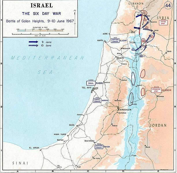
File:1967 Six Day War - Battle of Golan Heights.jpg

Fitxer original (904 × 884 píxels, mida del fitxer: 109 Ko, tipus MIME: image/jpeg)
Llegendes
Llegendes

|
File:1967 Six Day War - Battle of Golan Heights.svg és una versió vectorial (SVG) d'aquest fitxer. En cas de ser millor, hauria de ser emprada en lloc d'aquesta imatge tramada.
File:1967 Six Day War - Battle of Golan Heights.jpg → File:1967 Six Day War - Battle of Golan Heights.svg
Per a més informació pel que fa als gràfics vectorials, llegiu la transició a SVG en Commons. També hi ha informació quant a la compatibilitat del MediaWiki amb les imatges SVG. |
 |
- Source: Department of History, U.S. Military Academy
- URL: [1] archive copy at the Wayback Machine
- Background information:
In 1938 the predecessors of what is today The Department of History at the United States Military Academy began developing a series of campaign atlases to aid in teaching cadets a course entitled, "History of the Military Art." Since then, the Department has produced over six atlases and more than one thousand maps, encompassing not only America’s wars but global conflicts as well.
In keeping abreast with today's technology, the Department of History is providing these maps on the internet as part of the department's outreach program. The maps were created by the United States Military Academy’s Department of History and are the digital versions from the atlases printed by the United States Defense Printing Agency. We gratefully acknowledge the accomplishments of the department's former cartographer, Mr. Edward J. Krasnoborski, along with the works of our present cartographer, Mr. Frank Martini.
Please be aware that these maps are large in file size and may require substantial download times.
Aquesta imatge és obra d'un soldat o empleat de l'exèrcit dels EUA feta durant la prestació oficial de servei. Com a obra del govern federal dels EUA, la imatge és en el domini públic.
|
 |
derivative works
[modifica]
Derivative works of this file: Israel 1949-1967.svg
Historial del fitxer
Cliqueu una data/hora per veure el fitxer tal com era aleshores.
| Data/hora | Miniatura | Dimensions | Usuari/a | Comentari | |
|---|---|---|---|---|---|
| actual | 10:29, 24 jul 2005 | | 904 × 884 (109 Ko) | Humus sapiens~commonswiki (discussió | contribucions) | *Source: Department of History, U.S. Military Academy *URL: [http://www.dean.usma.edu/history/web03/atlases/map%20home.htm] *Background information: ''In 1938 the predecessors of what is today The Department of History at the United States Military Acade |
No podeu sobreescriure aquest fitxer.
Ús del fitxer
Les 4 pàgines següents utilitzen aquest fitxer:
Ús global del fitxer
Utilització d'aquest fitxer en altres wikis:
- Utilització a en.wikipedia.org
- Utilització a nl.wikipedia.org