File:19730705200R Dresden-Pieschen Molenbrücke Leipziger Straße.jpg
Jump to navigation
Jump to search

Size of this preview: 800 × 362 pixels. Other resolutions: 320 × 145 pixels | 640 × 290 pixels | 1,024 × 463 pixels | 1,280 × 579 pixels | 2,577 × 1,166 pixels.
Original file (2,577 × 1,166 pixels, file size: 1.16 MB, MIME type: image/jpeg)
Captions
Captions
Add a one-line explanation of what this file represents
Summary
[edit]| Description |
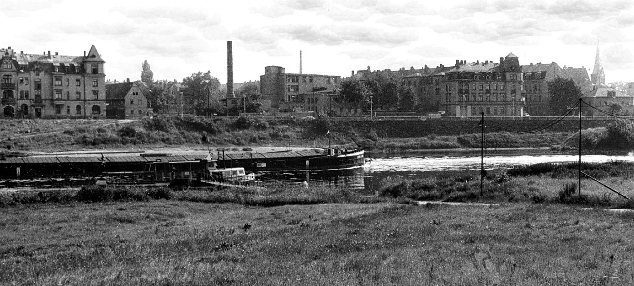
Deutsch: 05.07.1973 DDR 8023 [01127] Dresden-Pieschen: Blick von der Schlachthofinsel über die Elbe nach Pieschen. Links das Haus Leipziger Straße 99 (GMP: 51.077110,13.717396). Das kleine Haus mit Satteldach rechts davon wird nach der Wende für das dann hier errichtete Elbecenter 1 (GMP: 51.077344,13.717899) abgerissen, ebenso der Schornstein. Das an der Bürgerstraße stehende Gewerbegebäude mit dem Aufzugsturm rechts vom Schornstein (GMP: 51.077305,13.718831) gehört zur Anschrift Leipziger Straße 112 und steht 2010 noch. Fast am rechten Bildrand steht das Wohnhaus Leipziger Straße 110 / Ecke Rehefelder Straße 1 (GMP: 51.076666,13.719090). Im Vordergrund am gegenüberliegenden Elbufer liegt die Einfahrt in den Pieschner Hafen / Winterhafen (GMP 51.073821,13.721491). 2010 wird hier die Molenbrücke (GMP 51.076409,13.718380) eröffnet. Eine erste städtebauliche Planung dafür gab es bereits 1973 in der Diplomarbeit "Mischgebiet Dresden-Neustadt / Leipziger Vorstadt" der Architekturstudenten J. Blobelt, S. Rex, Chr. Kutschka, F. Buck und M. Fröhlich. Zu diesem Zweck entstand dieses Foto. [F]19730705200AR.JPG(c)Blobelt |
||||||||||||||
| Date | |||||||||||||||
| Source | Own work | ||||||||||||||
| Author |
|
||||||||||||||

| Object location | | View this and other nearby images on: OpenStreetMap |
|---|
| Camera location | | View this and other nearby images on: OpenStreetMap |
|---|
Licensing
[edit]
This file is licensed under the Creative Commons Attribution-Share Alike 4.0 International license.
- You are free:
- to share – to copy, distribute and transmit the work
- to remix – to adapt the work
- Under the following conditions:
- attribution – You must give appropriate credit, provide a link to the license, and indicate if changes were made. You may do so in any reasonable manner, but not in any way that suggests the licensor endorses you or your use.
- share alike – If you remix, transform, or build upon the material, you must distribute your contributions under the same or compatible license as the original.
File history
Click on a date/time to view the file as it appeared at that time.
| Date/Time | Thumbnail | Dimensions | User | Comment | |
|---|---|---|---|---|---|
| current | 22:36, 7 December 2018 | | 2,577 × 1,166 (1.16 MB) | Jörg Blobelt (talk | contribs) | User created page with UploadWizard |
You cannot overwrite this file.
File usage on Commons
The following 4 pages use this file: