File:1F244039030EFF8700P1151L0M1.jpg
پرش به ناوبری
پرش به جستجو
اندازهٔ این پیشنمایش: ۶۰۰ × ۶۰۰ پیکسل. کیفیتهای دیگر: ۲۴۰ × ۲۴۰ پیکسل | ۴۸۰ × ۴۸۰ پیکسل | ۷۶۸ × ۷۶۸ پیکسل | ۱٬۰۲۴ × ۱٬۰۲۴ پیکسل.
پروندهٔ اصلی (۱٬۰۲۴ × ۱٬۰۲۴ پیکسل، اندازهٔ پرونده: ۱۳۲ کیلوبایت، نوع MIME پرونده: image/jpeg)
گزینهها
عنوان
شرحی یکخطی از محتوای این فایل اضافه کنید
خلاصه
[ویرایش]
| توضیح |
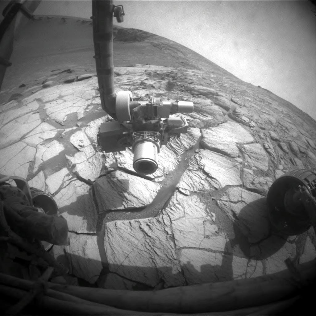
English: A layer of light-toned rock exposed inside Victoria Crater in the Meridiani Planum region of Mars appears to mark where the surface was at the time, many millions of years ago, when an impact excavated the crater. NASA's Mars Exploration Rover Opportunity drove to this bright band as the science team's first destination for the rover during investigations inside the crater. Opportunity's left front hazard-identification camera took this image just after the rover finished a drive of 2.25 meters (7 feet, 5 inches) during the rover's 1,305th Martian day, or sol, (Sept. 25, 2007). The rocks beneath the rover and its extended robotic arm are part of the bright band.
Victoria Crater has a scalloped shape of alternating alcoves and promontories around the crater's circumference. Opportunity descended into the crater two weeks earlier, within an alcove called "Duck Bay." Counterclockwise around the rim, just to the right of the arm in this image, is a promontory called "Cabo Frio." |
| تاریخ | |
| منبع | http://marsrovers.jpl.nasa.gov/gallery/all/1/f/1305/1F244039030EFF8700P1151L0M1.HTML and http://www.nasa.gov/mission_pages/mer/images/caption20070926.html |
| پدیدآور | NASA/JPL-Caltech |
این نگاره یا ویدیو توسط آزمایشگاه نیروی محرکهٔ جت سازمان ملی هوانوردی و فضایی (NASA)ایالات متحدهٔ آمریکا تحت شناسهٔ عکس: 1F244039030EFF8700P1151L0M1کاتالوگ شدهاست. این برچست وضعیت حق تکثیر اثر ضمیمه شده را مشخص نمیکند. یک برچسپ معمولی همچنان مورد نیاز است. Commons:Licensing را برای کسب اطلاعات مشاهده فرمایید. زبانهای دیگر:
|
اجازهنامه
[ویرایش]
| این پرونده در مالکیت عمومی قرار دارد چرا که توسط ناسا ایجاد شده است. سیاست حق تکثیر ناسا بیان میکند که «مواد ناسا با حق تکثیر محافظت نمیشوند، مگراینکه ذکر شده باشد». (Template:PD-USGov، صفحهٔ سیاست حق تکثیر ناسا یا سیاست جیپیال استفاده از تصاویر را ببینید.) | ||
 |
هشدارها:
|
تاریخچهٔ پرونده
روی تاریخ/زمانها کلیک کنید تا نسخهٔ مربوط به آن هنگام را ببینید.
| تاریخ/زمان | بندانگشتی | ابعاد | کاربر | توضیح | |
|---|---|---|---|---|---|
| کنونی | ۱۶ فوریهٔ ۲۰۱۳، ساعت ۰۳:۴۲ | | ۱٬۰۲۴ در ۱٬۰۲۴ (۱۳۲ کیلوبایت) | Huntster (بحث | مشارکتها) | == {{int:filedesc}} == {{Information |Description={{en|1=A layer of light-toned rock exposed inside Victoria Crater in the Meridiani Planum region of Mars appears to mark where the surface was at the time, many millions of years ago, when an impact exc... |
شما نمیتوانید این پرونده را رونویسی کنید.
کاربرد پرونده
صفحهٔ زیر از این تصویر استفاده میکند:
کاربرد سراسری پرونده
ویکیهای دیگر زیر از این پرونده استفاده میکنند:
- کاربرد در fa.wikipedia.org