File:1FFB03. Neolithic to Bronze Age flint scraper (FindID 205063).jpg
Jump to navigation
Jump to search

Size of this preview: 800 × 425 pixels. Other resolutions: 320 × 170 pixels | 640 × 340 pixels | 1,024 × 544 pixels | 1,280 × 680 pixels | 2,705 × 1,436 pixels.
Original file (2,705 × 1,436 pixels, file size: 849 KB, MIME type: image/jpeg)
Captions
Captions
Add a one-line explanation of what this file represents
Summary[edit]
.jpg&action=edit§ion=1)
| 1FFB03. Neolithic to Bronze Age flint scraper | |||
|---|---|---|---|
| Photographer |
Somerset County Council, Ciorstaidh Hayward Trevarthen, 2008-01-15 16:00:03 |
||
| Title |
1FFB03. Neolithic to Bronze Age flint scraper |
||
| Description |
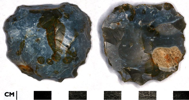
English: A large, coarsely worked discoidal flint scraper. Light grey-brown flint with a blue-white milky, mid-gloss patina. Sub circular in shape and made on a tertiary flake. The dorsal face is convex and the ventral is slightly concave. The ventral face has been plough damaged. The dorsal face has several flaking scars from earlier working of the core from which the flake was struck. Although there is a lot of plough damage to the edges of the scraper, it appears to have been coarsely retouched around three quarters of its circumference.
Date: Late Neolithic to Early Bronze Age - C. 2500 BC to 1500 BC Dimensions: 48 mm x 50 mm x 19 mm Weight: 51 g |
||
| Depicted place | (County of findspot) Dorset | ||
| Date | between 2500 BC and 1500 BC | ||
| Accession number |
FindID: 205063 Old ref: DOR-1FFB03 Filename: 1FFB03.JPG |
||
| Credit line |
|
||
| Source |
https://finds.org.uk/database/ajax/download/id/161889 Catalog: https://finds.org.uk/database/images/image/id/161889/recordtype/artefacts archive copy at the Wayback Machine Artefact: https://finds.org.uk/database/artefacts/record/id/205063 |
||
| Permission (Reusing this file) |
Attribution-ShareAlike License version 4.0 (verified 17 November 2020) | ||
| Object location | | View this and other nearby images on: OpenStreetMap |
|---|
.jpg¶ms=050.711700_N_-002.442070_E_globe:Earth_class:object_type:object__&language=en)
Licensing[edit]
.jpg&action=edit§ion=2)
This file is licensed under the Creative Commons Attribution-Share Alike 4.0 International license.
Attribution: The Portable Antiquities Scheme/ The Trustees of the British Museum
- You are free:
- to share – to copy, distribute and transmit the work
- to remix – to adapt the work
- Under the following conditions:
- attribution – You must give appropriate credit, provide a link to the license, and indicate if changes were made. You may do so in any reasonable manner, but not in any way that suggests the licensor endorses you or your use.
- share alike – If you remix, transform, or build upon the material, you must distribute your contributions under the same or compatible license as the original.
File history
Click on a date/time to view the file as it appeared at that time.
| Date/Time | Thumbnail | Dimensions | User | Comment | |
|---|---|---|---|---|---|
| current | 04:14, 4 February 2017 | | 2,705 × 1,436 (849 KB) | Fæ (talk | contribs) | Portable Antiquities Scheme, DOR, FindID: 205063, neolithic, page 4521, batch sort-updated count 41664 |
You cannot overwrite this file.
File usage on Commons
The following page uses this file:
.jpg)
.jpg&oldid=806629580)