File:20070309240DR Dresden-Weißer Hirsch Chinesischer Pavillon.jpg
Jump to navigation
Jump to search

Size of this preview: 791 × 599 pixels. Other resolutions: 317 × 240 pixels | 634 × 480 pixels | 1,014 × 768 pixels | 1,280 × 970 pixels | 2,419 × 1,833 pixels.
Original file (2,419 × 1,833 pixels, file size: 5.29 MB, MIME type: image/jpeg)
Captions
Captions
Add a one-line explanation of what this file represents
Summary
[edit]| Description |
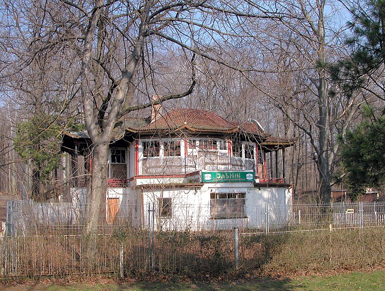
Deutsch: 09.03.2007 01324 Dresden-Weißer Hirsch: Chinesischer Pavillon (GMP: 51.064054,13.824155). 1911 wurde der Chinesische Pavillon als offizieller Beitrag der Regierung des Kaiserreich Chinas zur Internationalen Hygieneausstellung errichtet. Es entstand das Chinesische Teehaus, später als Lesecafe (Waldcafe) bekannt. Das Gebäude gefiel so sehr, daß es die Gemeinde Weißer Hirsch für 7000 RM erworben hatte und am 01.08.1912 als Lesehalle eröffnet wurde. Später kam im Untergeschoß eine Filiale von Pfunds Molkerei hinzu, ab 1922 gehörten auch Konditoreiwaren zum Angebot. 1943 wurde der Kurbetrieb im beanachbarten Lahmann-Sanatorium eingestellt. So wurde 1943 auch der
Teepavillon geschlossen, dann aber 1951 als Gaststätte wieder eröffnet. 1961 wurde die Gaststätte im Teehaus in das Lesecafe "Zeit im Bild" umgewandelt. Schließlich aber firmierte der Pavillon unter "HO-Waldcafe Weißer Hirsch". In den ersten beiden Jahren nach der Wende arbeitet eine Werbeagentur in den Räumen, dann eröffnete das erste Dresdner Chinarestaurant "Jasmin" im passenden Ambiente. In der Nacht vom 27. zum 28.08.1997 brannte Deutschlands einziges original chinesisches Bauwerk fast völlig aus. Der nachfolgende Vandalismus richtete schweren Schaden an, so daß sogar an Abriß des denkmalgeschützten Objektes gedacht worden war. Die Rettung kam mit der Gründung des "Chinesischer Pavillon zu Dresden e.V." Ende 2005, der im folgenden Jahr das Gebäude von der Stadt kaufte. Derzeit (2007) Ruine. Sicht von Südwesten. [DSCN21296.TIF]20070309240DR.JPG(c)Blobelt |
||||||||||||||
| Date | |||||||||||||||
| Source | Own work | ||||||||||||||
| Author |
|
||||||||||||||

| Object location | | View this and other nearby images on: OpenStreetMap |
|---|
Licensing
[edit]
I, the copyright holder of this work, hereby publish it under the following license:
This file is licensed under the Creative Commons Attribution-Share Alike 4.0 International license.
- You are free:
- to share – to copy, distribute and transmit the work
- to remix – to adapt the work
- Under the following conditions:
- attribution – You must give appropriate credit, provide a link to the license, and indicate if changes were made. You may do so in any reasonable manner, but not in any way that suggests the licensor endorses you or your use.
- share alike – If you remix, transform, or build upon the material, you must distribute your contributions under the same or compatible license as the original.
File history
Click on a date/time to view the file as it appeared at that time.
| Date/Time | Thumbnail | Dimensions | User | Comment | |
|---|---|---|---|---|---|
| current | 20:55, 1 November 2023 | | 2,419 × 1,833 (5.29 MB) | Jörg Blobelt (talk | contribs) | Uploaded own work with UploadWizard |
You cannot overwrite this file.
File usage on Commons
The following 3 pages use this file: