File:2011Sendai-NOAA-TravelTime-Ttvulhvpd9-06.jpg
跳转到导航
跳转到搜索

本预览的尺寸:655 × 600像素。 其他分辨率:262 × 240像素 | 524 × 480像素 | 900 × 824像素。
原始文件 (900 × 824像素,文件大小:532 KB,MIME类型:image/jpeg)
说明
说明
添加一行文字以描述该文件所表现的内容
| 描述 |
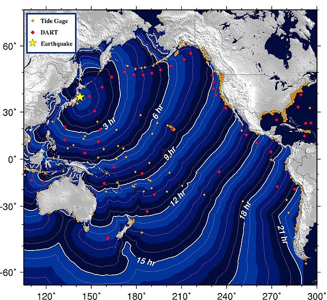
English: Estimated tsunami travel time forecast map for the 2011 Sendai earthquake from the U.S. NOAA
|
|||
| 日期 | ||||
| 来源 | wcatwc.arh.noaa.gov (direct image URL [1]) | |||
| 作者 | West Coast & Alaska Tsunami Warning Center, National Oceanic and Atmospheric Administration | |||
| 授权 (二次使用本文件) |
|
![[1]](http://wcatwc.arh.noaa.gov/2011/03/11/lhvpd9/06/ttvulhvpd9-06.jpg)
文件历史
点击某个日期/时间查看对应时刻的文件。
| 日期/时间 | 缩略图 | 大小 | 用户 | 备注 | |
|---|---|---|---|---|---|
| 当前 | 2011年3月11日 (五) 19:10 | | 900 × 824(532 KB) | Greenshed(留言 | 贡献) | crop heading - more flexible to use vector characters rather than embedded bitmapped text |
| 2011年3月11日 (五) 10:46 |  | 900 × 870(162 KB) | Clindberg(留言 | 贡献) | {{Information |Description=Estimated tsunami travel time forecast map for the 2011 Sendai earthquake from the U.S. NOAA |Source=[http://wcatwc.arh.noaa.gov/2011/03/11/lhvpd9/06/messagelhvpd9-06.htm wcatwc.arh.noaa.gov] (direct image URL [http://wcatwc.arh |
您不可以覆盖此文件。
文件用途
没有页面使用本文件。
全域文件用途
以下其他wiki使用此文件:
- af.wikipedia.org上的用途
- ar.wikipedia.org上的用途
- ast.wikipedia.org上的用途
- bg.wikipedia.org上的用途
- bg.wikinews.org上的用途
- ca.wikipedia.org上的用途
- ca.wikinews.org上的用途
- cs.wikipedia.org上的用途
- da.wikipedia.org上的用途
- de.wikipedia.org上的用途
- el.wikinews.org上的用途
- en.wikipedia.org上的用途
- en.wikinews.org上的用途
- en.wikiquote.org上的用途
- eo.wikipedia.org上的用途
- eo.wikinews.org上的用途
- es.wikipedia.org上的用途
- es.wikinews.org上的用途
- fi.wikipedia.org上的用途
- fr.wikipedia.org上的用途
- fr.wikinews.org上的用途
- he.wikipedia.org上的用途
- ja.wikipedia.org上的用途
- ja.wikinews.org上的用途
- 利用者:っ/テンプレート一覧
- ウィキニュース:Template メッセージの一覧/情報ボックス
- 日本・三陸沖を震源とするマグニチュード8.8の地震、東京など各地でも揺れや津波も
- テンプレート:2011年東北地方太平洋沖地震
- 東日本大震災 岩手県宮古市で37.9mの大津波 - 東大地震研究所調査
- 東日本大震災 岩手県宮古市の津波は38.9mまで到達 - 東京海洋大学調べ
- 関西電力、管内の企業や家庭に15%の節電を要請
- 岩手県の松「送り火」参加中止-放射能風評-京都
- 五山送り火、「セシウム」で二転三転の筋書き-京都
- 東日本大震災の義援金を着服容疑、ライオンズクラブの前議長を逮捕
- 東日本大震災の津波で流された漁船がカナダ沖合で発見される
- 東日本大震災被災地のサッカーボールがアラスカに漂着 持ち主は岩手県の高校生
- 米空母乗組員、東電訴える
- 福島県の3町村の避難区域再編を決定 - 葛尾村・富岡町・浪江町
- セシウム、99%で不検出 福島の内部被曝2万人調査で
- 常磐線広野-竜田復旧を進める JR
- 三陸鉄道が3年ぶりに全面復旧
- 検察審査会、福島原発事故に関して東電元幹部を「起訴すべき」と議決
- 漁船、8,000キロメートル漂流? 中のいけすには生きた魚も
- kab.wikipedia.org上的用途
- ko.wikipedia.org上的用途
查看本文件的更多全域用途。