File:2016 US map of drug overdose deaths per 100,000 population by state.gif

Fitxer original (1.297 × 827 píxels, mida del fitxer: 95 Ko, tipus MIME: image/gif)
Llegendes
Llegendes

|
Aquesta imatge (de tipus health map) s'hauria de tornar a crear utilitzant gràfics vectorials com ara un fitxer SVG. Això té diversos avantatges; en trobareu més informació a Commons:Media for cleanup. Si ja disposeu d'una versió d'aquesta imatge en format SVG, us preguem que la pengeu; després, reemplaceu aquesta plantilla amb la plantilla {{Vector version available|nom nou de la imatge.svg}} en aquesta imatge.
|
For more help with maps see:
| The map legend can be added to the map caption: |
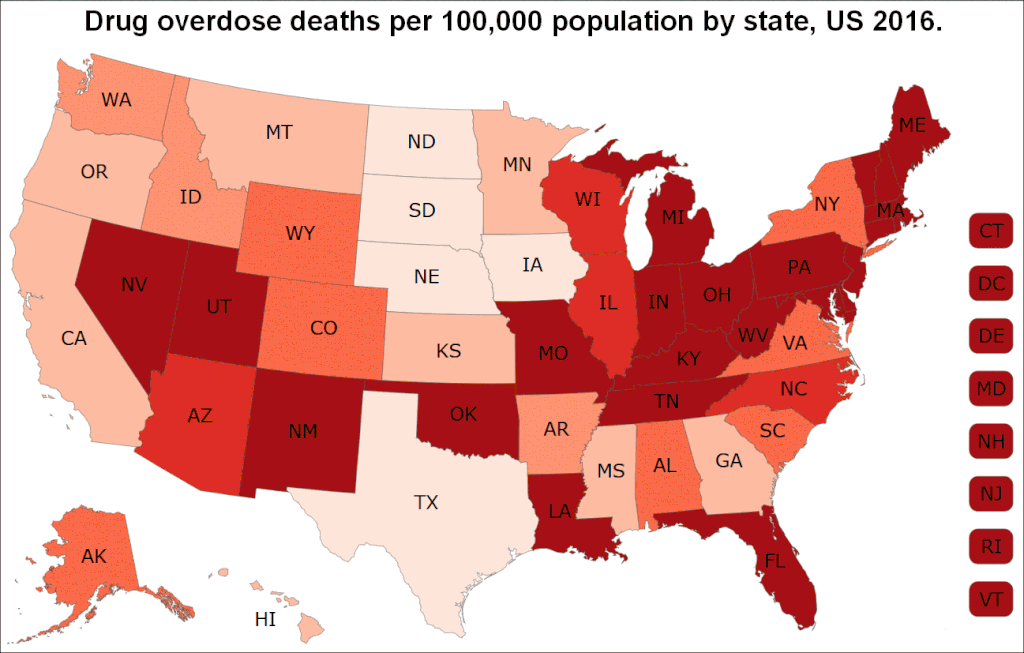
 6.9–11 11.1–13.5 13.6–16.0 16.1–18.5 18.6–21.0 21.1–52.0 |
Map legend via image:

Map legend via wikitext:
Drug overdose deaths per 100,000 people
6.9–11 11.1–13.5 13.6–16.0 16.1–18.5 18.6–21.0 21.1–52.0 |
The map legend can be combined with the map caption text in various ways:
6.9–11 11.1–13.5 13.6–16.0 16.1–18.5 18.6–21.0 21.1–52.0 |
6.9–11 11.1–13.5 13.6–16.0 | 16.1–18.5 18.6–21.0 21.1–52.0 |
6.9–11 11.1–13.5 13.6–16.0 | 16.1–18.5 18.6–21.0 21.1–52.0 |
Resum[modifica]
Note: Please do not upload new versions (2017 and later) here. This 2016 map is used in some articles where it is captioned specifically with 2016 data on various drugs and specific states. There is a newer map here.
| Descripció |
English: US map of drug overdose deaths per 100,000 population by state, US 2016. There were 64,070 overdose deaths in the USA in 2016 according to a table from the Centers for Disease Control and Prevention. From the source page for the map: "Opioids—prescription and illicit—are the main driver of drug overdose deaths. Opioids were involved in 42,249 deaths in 2016, and opioid overdose deaths were five times higher in 2016 than 1999. In 2016, the five states with the highest rates of death due to drug overdose were West Virginia (52.0 per 100,000), Ohio (39.1 per 100,000), New Hampshire (39.0 per 100,000), Pennsylvania (37.9 per 100,000) and Kentucky (33.5 per 100,000)." |
| Data | 30 de novembre de 2017. Date map was first uploaded to Commons. |
| Font | Drug Overdose Deaths. Centers for Disease Control and Prevention, National Center for Injury Prevention and Control. Click on a map year. The numbers are in the data table below the map. Numbers of deaths for each state, and the age-adjusted rates of death per 100,000 population for each state. You can also place your mouse cursor on a state on the map to get the data. |
| Autor | Centers for Disease Control and Prevention. User:Timeshifter cropped the map, and edited the text at the top, using freeware IrfanView. Map image came via "print screen" key on a keyboard. |
Llicència[modifica]
This image is a work of the Centers for Disease Control and Prevention, part of the United States Department of Health and Human Services, taken or made as part of an employee's official duties. As a work of the U.S. federal government, the image is in the public domain.
|
Historial del fitxer
Cliqueu una data/hora per veure el fitxer tal com era aleshores.
| Data/hora | Miniatura | Dimensions | Usuari/a | Comentari | |
|---|---|---|---|---|---|
| actual | 18:36, 22 maig 2018 | | 1.297 × 827 (95 Ko) | Timeshifter (discussió | contribucions) | New version. 2016. |
| 19:58, 30 nov 2017 |  | 1.703 × 1.062 (155 Ko) | Timeshifter (discussió | contribucions) | User created page with UploadWizard |
No podeu sobreescriure aquest fitxer.
Ús del fitxer
Les 6 pàgines següents utilitzen aquest fitxer:
Ús global del fitxer
Utilització d'aquest fitxer en altres wikis:
- Utilització a ca.wikipedia.org
- Utilització a en.wikipedia.org
- Utilització a en.wikiquote.org
- Utilització a es.wikipedia.org
- Utilització a hy.wikipedia.org