File:20190505205DR Dresden-Dölzschen Neumühle + Alte Königsmühle.jpg
Jump to navigation
Jump to search

Size of this preview: 800 × 540 pixels. Other resolutions: 320 × 216 pixels | 640 × 432 pixels | 1,024 × 691 pixels | 1,280 × 864 pixels | 2,560 × 1,729 pixels | 3,516 × 2,374 pixels.
Original file (3,516 × 2,374 pixels, file size: 6.63 MB, MIME type: image/jpeg)
Captions
Captions
Add a one-line explanation of what this file represents
Summary
[edit]| Description |
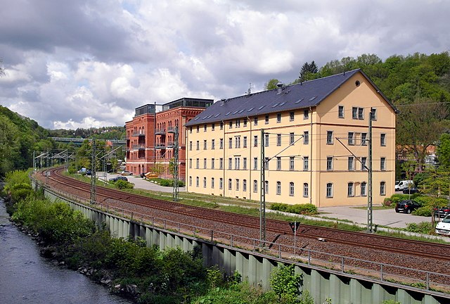
Deutsch: 05.05.2019 01187 Dresden-Dölzschen im Gebiet Felsenkeller / Plauenscher Grund: Sicht von Südosten, vom Coselweg in Coschütz, über die Vereinigte Weißeritz. An ihrem Ufer verläuft die Bahntrasse der Sachsen-Franken-Magistrale Dresden – Plauen. Das ockergelbe Gebäude im Vordergrund ist die "Neue Königsmühle" Tharandter Straße 105 (GMP: 51.022372,13.698180), erbaut 1858 als Wohn-, Verwaltungs- und Mühlengebäude, 2016 zur Wohnanlage umgebaut. Das rote Gebäude links dahinter ist die "Alte Königsmühle" Tharandter Straße 109 (GMP: 51.022336,13.697134), ehemals Saatgutlager. Der Klinkerbau wurde 1878 auf dem Gelände der einstigen Königsmühle von 1739 errichtet, bis zur Wende als "Saatgut-Verkaufslager" genutzt und stand bis 2009 leer. Danach (2011/13) erfolgte die Sanierung und der Umbau zu Wohnzwecken. Auf dem Dach entstand ein gläsernes Galeriegeschoß mit zwei großen Loftwohnungen. [SAM0541.JPG]20190505205DR.JPG(c)Blobelt |
||||||||||||||
| Date | |||||||||||||||
| Source | Own work | ||||||||||||||
| Author |
|
||||||||||||||

| Object location | | View this and other nearby images on: OpenStreetMap |
|---|
Licensing
[edit]
This file is licensed under the Creative Commons Attribution-Share Alike 4.0 International license.
- You are free:
- to share – to copy, distribute and transmit the work
- to remix – to adapt the work
- Under the following conditions:
- attribution – You must give appropriate credit, provide a link to the license, and indicate if changes were made. You may do so in any reasonable manner, but not in any way that suggests the licensor endorses you or your use.
- share alike – If you remix, transform, or build upon the material, you must distribute your contributions under the same or compatible license as the original.
File history
Click on a date/time to view the file as it appeared at that time.
| Date/Time | Thumbnail | Dimensions | User | Comment | |
|---|---|---|---|---|---|
| current | 20:44, 5 May 2019 | | 3,516 × 2,374 (6.63 MB) | Jörg Blobelt (talk | contribs) | User created page with UploadWizard |
You cannot overwrite this file.
File usage on Commons
The following 3 pages use this file:
File usage on other wikis
The following other wikis use this file:
- Usage on de.wikipedia.org