File:2021-11-30 Rabaul, Papua New Guinea M6.1 earthquake shakemap (USGS).jpg
Jump to navigation
Jump to search

Size of this preview: 474 × 599 pixels. Other resolutions: 190 × 240 pixels | 379 × 480 pixels | 786 × 994 pixels.
Original file (786 × 994 pixels, file size: 197 KB, MIME type: image/jpeg)
Captions
Captions
Add a one-line explanation of what this file represents
Summary[edit]
.jpg&action=edit§ion=1)
| Description |
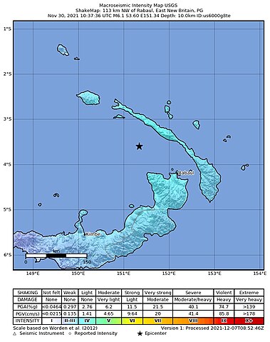
English: Shakemap from USGS for the magnitude 6.1, maximum intensity 4.425 earthquake near en:Usgs Neic Shakemap (113 km NW of en:Rabaul, Papua New Guinea), 10.0 km depth. |
| Date | |
| Source | https://earthquake.usgs.gov/earthquakes/eventpage/us6000g8te |
| Author | United States Geological Survey |
Licensing[edit]
.jpg&action=edit§ion=2)
This image is in the public domain in the United States because it only contains materials that originally came from the United States Geological Survey, an agency of the United States Department of the Interior. For more information, see the official USGS copyright policy.
|
File history
Click on a date/time to view the file as it appeared at that time.
| Date/Time | Thumbnail | Dimensions | User | Comment | |
|---|---|---|---|---|---|
| current | 09:03, 7 December 2021 | | 786 × 994 (197 KB) | Cewbot (talk | contribs) | Import USGS earthquake map, shakemap id: urn:usgs-product:us:shakemap:us6000g8te:1638867249539 (2021-12-07T08:54:09.539Z) |
You cannot overwrite this file.
File usage on Commons
There are no pages that use this file.
.jpg&oldid=860440250)