File:23-Sector Map Gov IFES St-Rg Hluttaw Election Results 2015 MIMU1351v01 05Feb2016 A3.pdf

Original file (1,754 × 2,479 pixels, file size: 2.05 MB, MIME type: application/pdf)
Captions
Captions
Summary[edit]
| Description |
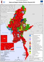
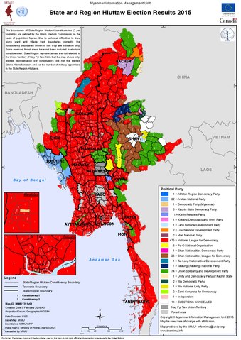
English: Electoral map created by the Myanmar Information Management Unit (MIMU). See the MIMU website and file name for more details. |
| Date | See map text |
| Source | Myanmar Information Management Unit (MIMU) |
| Author | United Nations Development Programme (UNDP) |
Licensing[edit]
| This image is a map derived from a United Nations map.
Unless stated otherwise, UN maps are to be considered in the public domain. This applies worldwide. UN maps are, in principle, open source material and you can use them in your work or for making your own map. UN requests however that you delete the UN name, logo and reference number upon any modification to the map. Content of your map will be your responsibility. You can state in your publication, if you wish, something like: based on UN map … (map name, map number, revision number and date). See: Geospatial Information Section. And: Geospatial, location data for a better world. |
 |
File history
Click on a date/time to view the file as it appeared at that time.
| Date/Time | Thumbnail | Dimensions | User | Comment | |
|---|---|---|---|---|---|
| current | 23:39, 31 January 2021 |  | 1,754 × 2,479 (2.05 MB) | RaviC (talk | contribs) | Uploaded a work by United Nations Development Programme (UNDP) from [http://themimu.info/sector/governance Myanmar Information Management Unit (MIMU)] with UploadWizard |
You cannot overwrite this file.
File usage on Commons
The following page uses this file:
File usage on other wikis
The following other wikis use this file:
- Usage on en.wikipedia.org
- Usage on es.wikipedia.org
- Usage on fr.wikipedia.org
- Usage on my.wikipedia.org
- Usage on shn.wikipedia.org
- Usage on vi.wikipedia.org