File:AGHRC (1890) - Carta VI - Guerras de independencia en Colombia, 1806-1814.jpg
Jump to navigation
Jump to search
Size of this preview: 740 × 599 pixels. Other resolutions: 296 × 240 pixels | 593 × 480 pixels | 948 × 768 pixels | 1,264 × 1,024 pixels | 2,529 × 2,048 pixels | 4,320 × 3,499 pixels.
Original file (4,320 × 3,499 pixels, file size: 5.88 MB, MIME type: image/jpeg)
Captions
Captions
Add a one-line explanation of what this file represents
Summary
[edit]| Description |
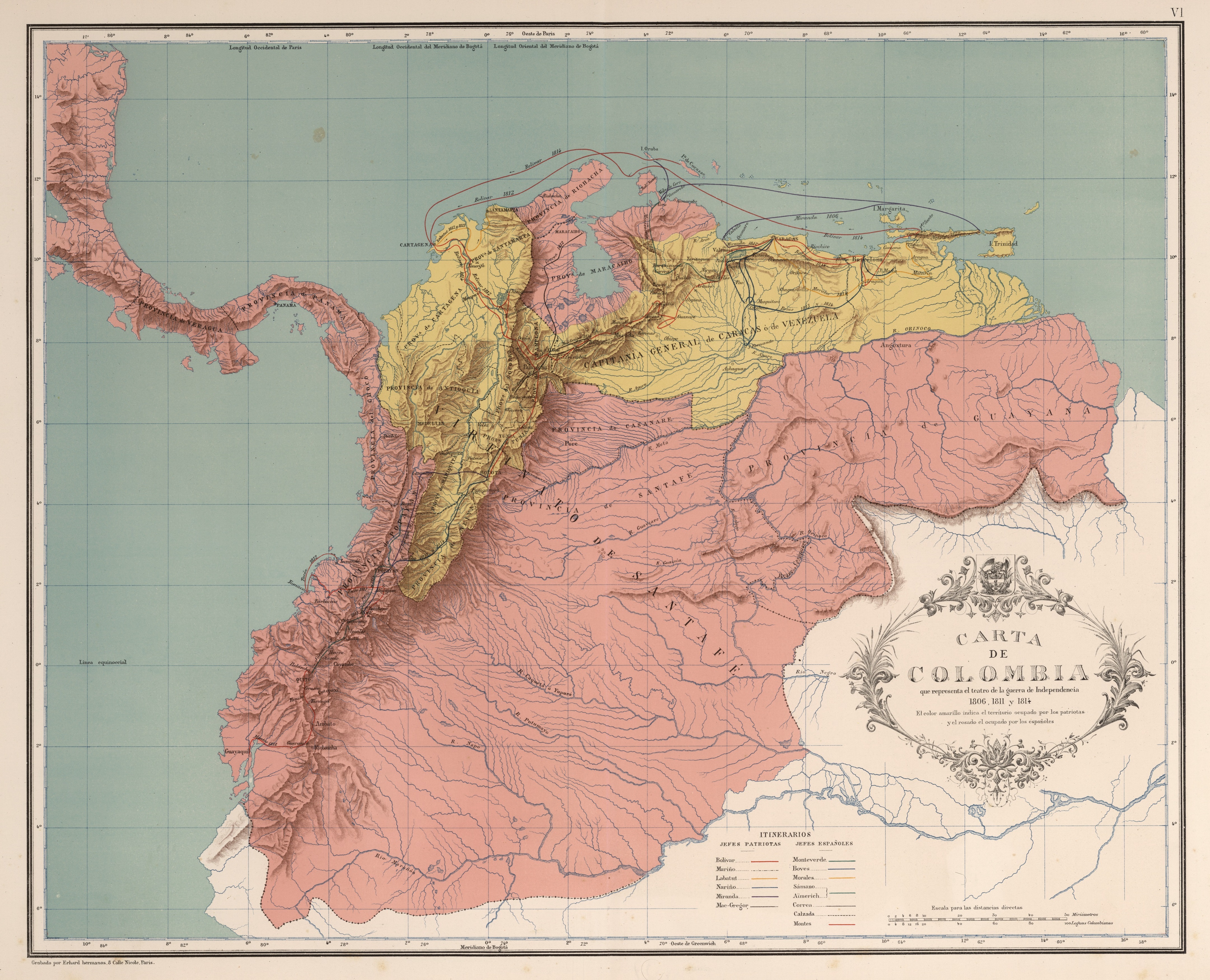
Español: Carta que representa el teatro de independencia años 1806, 1811 y 1814. Carta VI del Atlas geográfico e histórico de la República de Colombia, 1890. |
||||||||||||||||||||
| Date | |||||||||||||||||||||
| Source | Atlas geográfico e histórico de la República de Colombia, 1890. | ||||||||||||||||||||
| Author |
|
||||||||||||||||||||

_-_Carta_VI_-_Guerras_de_independencia_en_Colombia,_1806-1814.jpg&action=edit§ion=1)
Licensing
[edit]_-_Carta_VI_-_Guerras_de_independencia_en_Colombia,_1806-1814.jpg&action=edit§ion=2)
This file is in the public domain because the copyright of this work, registered in Colombia, has expired, according to “Law 23 of 1982 on Copyright, Articles 11, 21-29”, amended by “Law 44 of 1993, Article 2” and “Law 1520 of 2012, Articles 4, 6 and 10” (details). However, some restrictions have to be addressed:
|

|
File history
Click on a date/time to view the file as it appeared at that time.
| Date/Time | Thumbnail | Dimensions | User | Comment | |
|---|---|---|---|---|---|
| current | 13:40, 28 November 2018 | | 4,320 × 3,499 (5.88 MB) | Milenioscuro (talk | contribs) | high quality (from David Rumsey) |
| 04:34, 20 March 2009 |  | 2,855 × 2,317 (2.62 MB) | Milenioscuro (talk | contribs) | {{Information |Description={{es|1=Carta que representa el teatro de independencia años 1806, 1811 y 1814. Tomado del "Atlas geográfico e histórico de la República de Colombia", 1890.}} |Source=Atlas geográfico e histórico de la República de Colombi |
You cannot overwrite this file.
File usage on Commons
The following 4 pages use this file:
- Atlas Geográfico e Histórico de la República de Colombia (1890)
- User:Magog the Ogre/Maps of conflicts/2018 November
- File:Atlas Geográfico e Histórico de la República de Colombia (1890) - Carta VI - Guerras de independencia en Colombia, 1806-1814.jpg (file redirect)
- File:Guerras de independencia en Colombia 1806-14.jpg (file redirect)
_-_Carta_VI_-_Guerras_de_independencia_en_Colombia,_1806-1814.jpg&redirect=no)
File usage on other wikis
The following other wikis use this file:
- Usage on ast.wikipedia.org
- Usage on en.wikipedia.org
- Usage on es.wikipedia.org
- Usage on fr.wikipedia.org
- Usage on no.wikipedia.org
- Usage on www.wikidata.org
Metadata
_-_Carta_VI_-_Guerras_de_independencia_en_Colombia,_1806-1814.jpg&oldid=820214170)
Categories:
- Atlas Geográfico e Histórico de la República de Colombia (1890)
- Old maps of the Viceroyalty of New Granada
- Maps of Colombian war of Independence
- Maps of Venezuelan war of Independence
- 1810s
- Maps of the First Republic of Venezuela
- Maps of the Second Republic of Venezuela
- Old maps of the United Provinces of New Granada