File:AMH-6691-KB Map of North and South America.jpg
Jump to navigation
Jump to search

Size of this preview: 761 × 600 pixels. Other resolutions: 305 × 240 pixels | 609 × 480 pixels | 974 × 768 pixels | 1,280 × 1,009 pixels | 2,400 × 1,892 pixels.
Original file (2,400 × 1,892 pixels, file size: 846 KB, MIME type: image/jpeg)
Captions
Captions
Add a one-line explanation of what this file represents
Summary
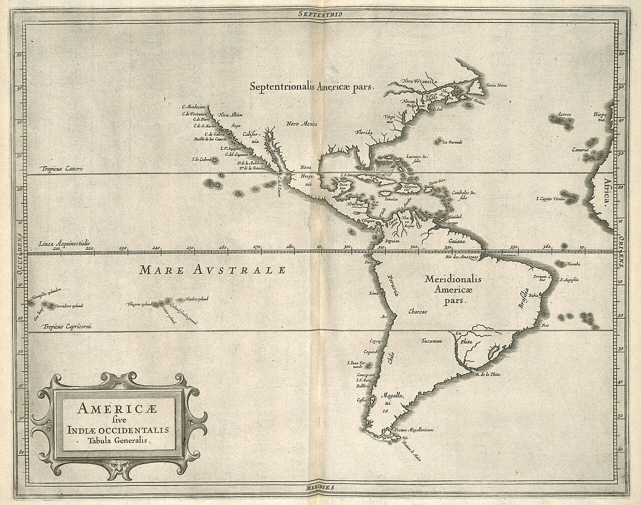
[edit]Nederlands: Kaart van Noord- en Zuid-Amerika
English: Map of North and South America( |
|||||||||||||||||||||
|---|---|---|---|---|---|---|---|---|---|---|---|---|---|---|---|---|---|---|---|---|---|
| Author |
Creator:B. Elsevier Creator:I. Elsevier Nederlands: B. Elsevier (uitgever), I. Elsevier (uitgever), Anoniem / Anonymous (landmeter / kaartenmaker)
English: B. Elsevier (publisher), I. Elsevier (publisher), Anoniem / Anonymous (land surveyor / mapmaker) |
||||||||||||||||||||
| Title |
Nederlands: Kaart van Noord- en Zuid-Amerika
English: Map of North and South America |
||||||||||||||||||||
| Description |
Nederlands: Kaart van Noord en Zuid-Amerika.
Americae sive Indiae occidentalis Tabula Generalis. Als gevolg van een rekenfout is de Atlantische Oceaan te klein.English: Map of North and South America.
Americae sive Indiae occidentalis Tabula Generalis. Due to an arithmetical error, the Atlantic Ocean is depicted too small. |
||||||||||||||||||||
| Date | circa 1630 | ||||||||||||||||||||
| Medium |
Nederlands: gravure op papier
English: engraving on paper |
||||||||||||||||||||
| Dimensions | height: 28.5 cm (11.2 in); width: 36.5 cm (14.3 in) | ||||||||||||||||||||
| Collection |
|
||||||||||||||||||||
| Accession number |
36 G 19 eerste kaart |
||||||||||||||||||||
| Inscriptions |
Americae sive Indiae occidentalis Tabula Generalis
|
||||||||||||||||||||
| Notes |
English: Subjects: chart / map / plan, banderole / cartouche / ornamentation
Nederlands: Onderwerpen: plattegrond / kaart, banderol / cartouche / versiering
English: Post: this image is related to a WIC trading post called Castro |
||||||||||||||||||||
| Source/Photographer |
|
||||||||||||||||||||
| Permission (Reusing this file) |
|
||||||||||||||||||||

| Object location | | View this and other nearby images on: OpenStreetMap |
|---|
File history
Click on a date/time to view the file as it appeared at that time.
| Date/Time | Thumbnail | Dimensions | User | Comment | |
|---|---|---|---|---|---|
| current | 11:22, 10 June 2014 | | 2,400 × 1,892 (846 KB) | HuskyBot (talk | contribs) | == {{int:filedesc}} == {{Artwork |title = {{nl|1=Kaart van Noord- en Zuid-Amerika}} {{en|1=Map of North and South America}} |description = {{nl|1=Kaart van Noord en Zuid-Amerika. ''Americae sive Indiae occiden... |
You cannot overwrite this file.
File usage on Commons
The following page uses this file:
File usage on other wikis
The following other wikis use this file:
- Usage on nl.wiktionary.org