File:AMH-7081-KB View of Fort Catoene.jpg
Jump to navigation
Jump to search
Size of this preview: 710 × 600 pixels. Other resolutions: 284 × 240 pixels | 568 × 480 pixels | 909 × 768 pixels | 1,212 × 1,024 pixels | 2,400 × 2,028 pixels.
Original file (2,400 × 2,028 pixels, file size: 1.28 MB, MIME type: image/jpeg)
Captions
Captions
Add a one-line explanation of what this file represents
Summary
[edit]Nederlands: Plattegrond van het fort Catoene
English: View of Fort Catoene( |
|||||||||||||||||||||
|---|---|---|---|---|---|---|---|---|---|---|---|---|---|---|---|---|---|---|---|---|---|
| Author |
Nederlands: Johann Carl Tetschner (uitgever), Johann Wolfgang Heydt (tekenaar en graveur)
English: Johann Carl Tetschner (publisher), Johann Wolfgang Heydt (draughtsman and engraver) |
||||||||||||||||||||
| Title |
Nederlands: Plattegrond van het fort Catoene
English: View of Fort Catoene |
||||||||||||||||||||
| Description |
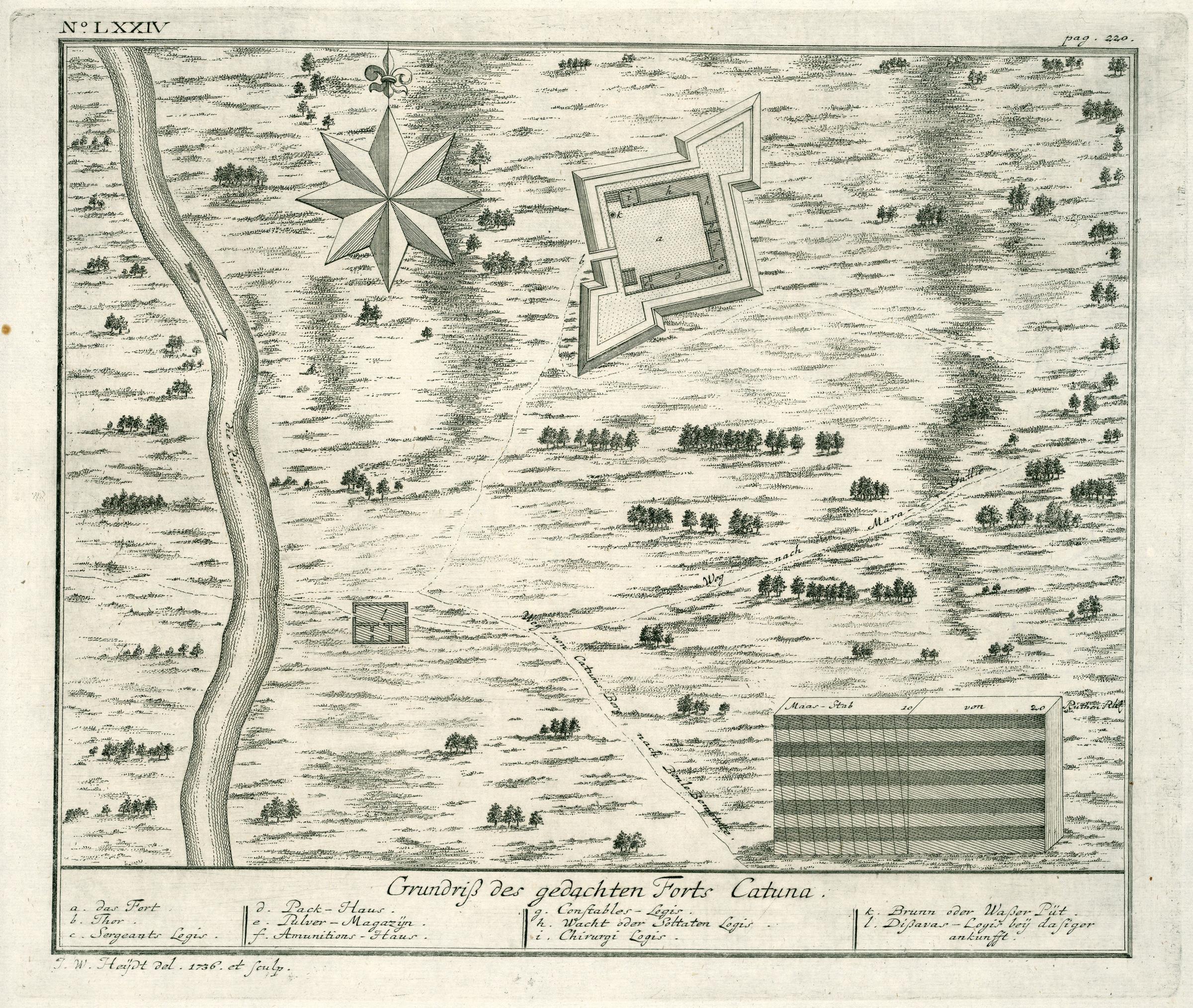
Nederlands: Plattegrond van het fort Catuna.
Grundriß des gedachten Forts Catuna. Legenda: a. das Fort. / b. Thor. / c. Sergeants Logis. / d. Pack-Haus. / e. Pulver-Magazijn. / f. Amunitions-Haus. / g. Constables-Logis. / h. Wacht oder Soltaten Logis. / i. Chirurgi Logis. / k. Brunn oder Waßer Püt. / l. Dißavas-Logis beij dasiger ankunfft..English: View of the Catuna fort.
Grundriß des gedachten Forts Catuna. Key: a. das Fort. / b. Thor. / c. Sergeants Logis. / d. Pack-Haus. / e. Pulver-Magazijn. / f. Amunitions-Haus. / g. Constables-Logis. / h. Wacht oder Soltaten Logis. / i. Chirurgi Logis. / k. Brunn oder Waßer Püt. / l. Dißavas-Logis beij dasiger ankunfft.. |
||||||||||||||||||||
| Date | 1736 | ||||||||||||||||||||
| Medium |
Nederlands: koperdruk op papier
English: copperplate printing on paper |
||||||||||||||||||||
| Dimensions | height: 29 cm (11.4 in); width: 24.5 cm (9.6 in) | ||||||||||||||||||||
| Collection |
|
||||||||||||||||||||
| Accession number |
2102 A 7, p. 220 |
||||||||||||||||||||
| Inscriptions |
Grundriß des gedachten Forts Catuna
author: J. W. Heijdt del. 1736. et sculp. |
||||||||||||||||||||
| Notes |
English: Subjects: chart / map / plan, compass / dial, key, fortification, building, house, powder magazine / powder mill, arsenal, tanck / well / watering hole, guard house / tollbooth
Nederlands: Onderwerpen: plattegrond / kaart, kompas / windroos, legenda, vesting, gebouw, huis / woonhuis, kruithuis / kruitmolen, arsenaal, tanck / waterplaats / put, tolhuis / wachthuis
English: Post: this image is related to a VOC trading post called Katuwana |
||||||||||||||||||||
| Source/Photographer |
|
||||||||||||||||||||
| Permission (Reusing this file) |
|
||||||||||||||||||||

| Object location | | View this and other nearby images on: OpenStreetMap |
|---|
File history
Click on a date/time to view the file as it appeared at that time.
| Date/Time | Thumbnail | Dimensions | User | Comment | |
|---|---|---|---|---|---|
| current | 12:25, 10 June 2014 | | 2,400 × 2,028 (1.28 MB) | HuskyBot (talk | contribs) | == {{int:filedesc}} == {{Artwork |title = {{nl|1=Plattegrond van het fort Catoene}} {{en|1=View of Fort Catoene}} |description = {{nl|1=Plattegrond van het fort Catuna. ''Grundriß des gedachten Forts Catuna''... |
You cannot overwrite this file.
File usage on Commons
The following page uses this file:
File usage on other wikis
The following other wikis use this file:
- Usage on ca.wikipedia.org
- Usage on en.wikipedia.org