File:AMH-7276-KB Map of the island of Anjouan.jpg
Original file (1,496 × 2,400 pixels, file size: 774 KB, MIME type: image/jpeg)
Captions
Captions
Summary
[edit]Nederlands: Kaart van het eiland Anjouan
English: Map of the island of Anjouan( |
|||||||||||||||||||||||||||||||||||||||
|---|---|---|---|---|---|---|---|---|---|---|---|---|---|---|---|---|---|---|---|---|---|---|---|---|---|---|---|---|---|---|---|---|---|---|---|---|---|---|---|
| Author |
Nederlands: Frederik Ottens (graveur / etser), J. van Braam (uitgever), Gerard onder de Linden (uitgever)
English: Frederik Ottens (engraver / etcher), J. van Braam (publisher), Gerard onder de Linden (publisher) |
||||||||||||||||||||||||||||||||||||||
| Title |
Nederlands: Kaart van het eiland Anjouan
English: Map of the island of Anjouan |
||||||||||||||||||||||||||||||||||||||
| Description |
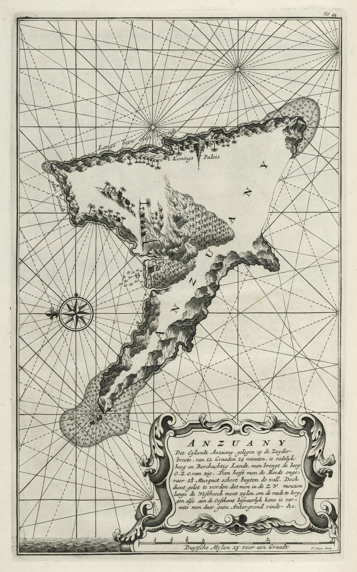
Nederlands: Kaart van het eiland Anjouan.
Anzuany. Dit Eylandt Anzuany, gelegen op de Zuyderbreete, van 12. Graaden 24 minuten, is redelyk hoog en Berchachtig Landt, men brengt de berg O.Z.O van zig, Dan heeft men de Reede ongevaer 1 1/2 Musquet schoot buyten de wall, Doch dient gelet te worden dat men in de Z.W. mouzon langs de Westhoeck moet zylen, om de reede te krygen also aen de Oostkant beswaerlyk kans is vermits men daar geen Ankergrond vindt &c. De kaart is afkomstig uit: 'Oud en Nieuw Oost-Indiën' van François Valentyn. Rechtsboven: No: 44. Op de Nederlandse loge staat een vlag.English: Map of the island of Anjouan.
Anzuany. Dit Eylandt Anzuany, gelegen op de Zuyderbreete, van 12. Graaden 24 minuten, is redelyk hoog en Berchachtig Landt, men brengt de berg O.Z.O van zig, Dan heeft men de Reede ongevaer 1 1/2 Musquet schoot buyten de wall, Doch dient gelet te worden dat men in de Z.W. mouzon langs de Westhoeck moet zylen, om de reede te krygen also aen de Oostkant beswaerlyk kans is vermits men daar geen Ankergrond vindt &c. The map is taken from: 'Oud en Nieuw Oost-Indiën' van François Valentyn. Top right: No: 44. The Dutch lodge flies a flag. |
||||||||||||||||||||||||||||||||||||||
| Date | 1726 | ||||||||||||||||||||||||||||||||||||||
| Medium |
Nederlands: gravure op papier
English: engraving on paper |
||||||||||||||||||||||||||||||||||||||
| Dimensions | height: 20 cm (7.8 in); width: 32 cm (12.5 in) | ||||||||||||||||||||||||||||||||||||||
| Collection |
|
||||||||||||||||||||||||||||||||||||||
| Accession number |
185 A 5 deel Vb, II, na p. 148 |
||||||||||||||||||||||||||||||||||||||
| Inscriptions |
Anzuany
author: F. Ottens direx. |
||||||||||||||||||||||||||||||||||||||
| Notes |
English: Subjects: chart / map / plan, bird's-eye view / elevation, elevation / bird's-eye view, banderole / cartouche / ornamentation, compass / dial, palace, house, building, anchorage / pier / harbour
Nederlands: Onderwerpen: plattegrond / kaart, vogelvlucht / opstand, opstand / vogelvlucht, banderol / cartouche / versiering, kompas / windroos, paleis, huis / woonhuis, gebouw, rede / haven / pier
English: Post: this image is related to a VOC trading post called Nzwani |
||||||||||||||||||||||||||||||||||||||
| Source/Photographer |
|
||||||||||||||||||||||||||||||||||||||
| Permission (Reusing this file) |
|
||||||||||||||||||||||||||||||||||||||

| Object location | | View this and other nearby images on: OpenStreetMap |
|---|
File history
Click on a date/time to view the file as it appeared at that time.
| Date/Time | Thumbnail | Dimensions | User | Comment | |
|---|---|---|---|---|---|
| current | 12:50, 10 June 2014 | | 1,496 × 2,400 (774 KB) | HuskyBot (talk | contribs) | == {{int:filedesc}} == {{Artwork |title = {{nl|1=Kaart van het eiland Anjouan}} {{en|1=Map of the island of Anjouan}} |description = {{nl|1=Kaart van het eiland Anjouan. ''Anzuany''. ''Dit Eylandt Anzuany,... |
You cannot overwrite this file.
File usage on Commons
The following page uses this file: