File:AMH-8027-KB Map of Celebes.jpg
跳转到导航
跳转到搜索
本预览的尺寸:421 × 600像素。 其他分辨率:168 × 240像素 | 337 × 480像素 | 539 × 768像素 | 718 × 1,024像素 | 1,684 × 2,400像素。
原始文件 (1,684 × 2,400像素,文件大小:609 KB,MIME类型:image/jpeg)
说明
说明
添加一行文字以描述该文件所表现的内容
摘要
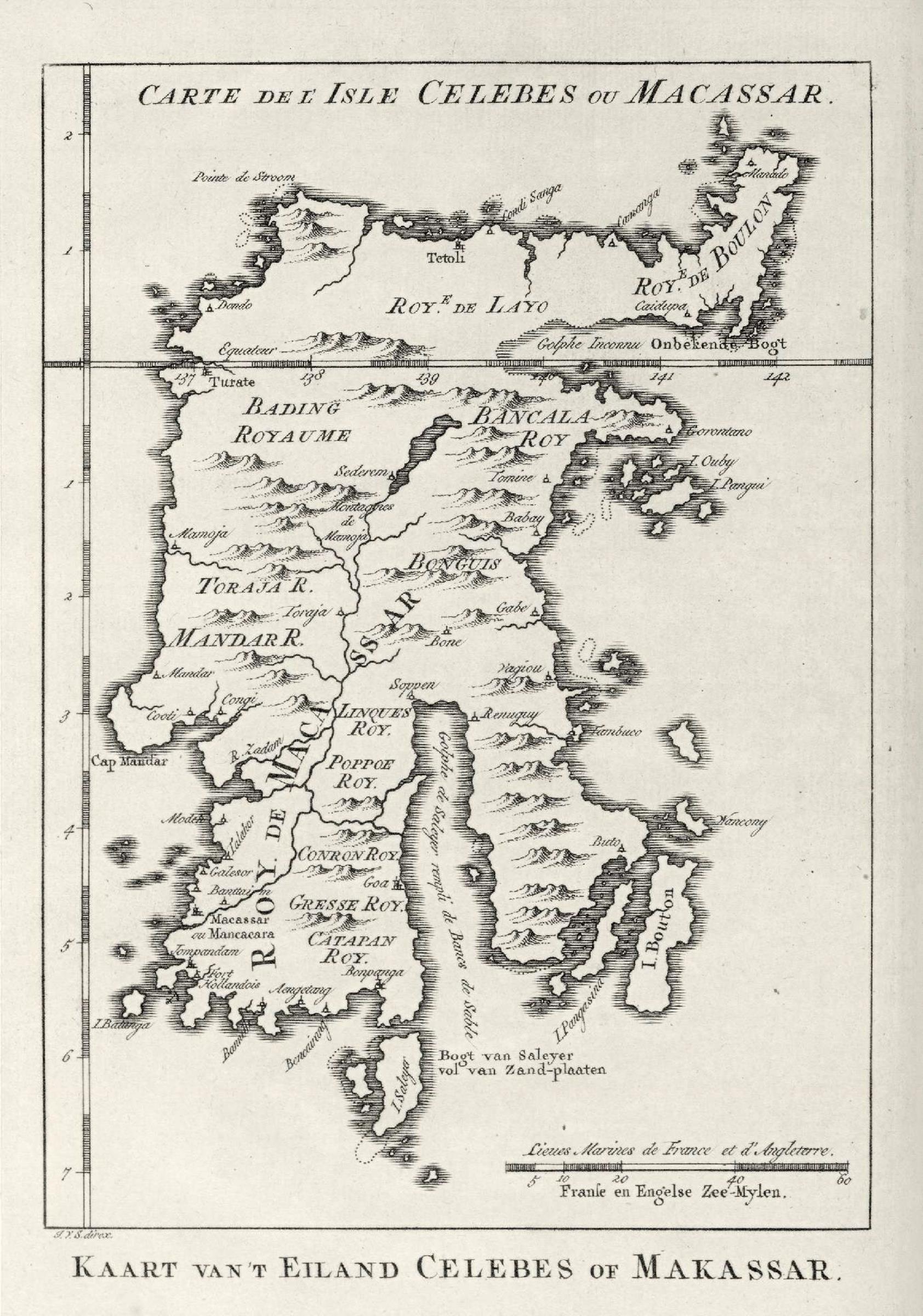
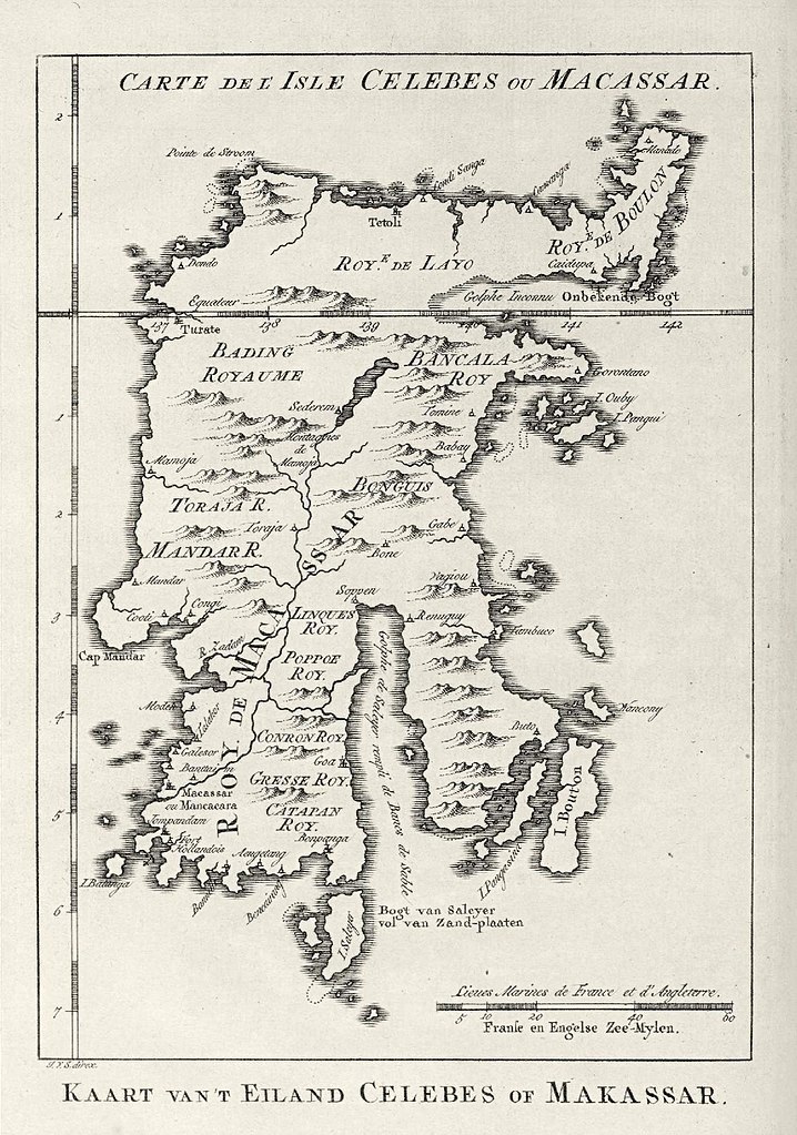
[编辑]Nederlands: Kaart van Celebes
English: Map of Celebes( |
|||||||||||||||||||||||||||||||||||||||||||||
|---|---|---|---|---|---|---|---|---|---|---|---|---|---|---|---|---|---|---|---|---|---|---|---|---|---|---|---|---|---|---|---|---|---|---|---|---|---|---|---|---|---|---|---|---|---|
| 作者 |
Nederlands: Pierre d' Hondt (uitgever), Jacobus van der Schley (direxit)
English: Pierre d' Hondt (publisher), Jacobus van der Schley (direxit) |
||||||||||||||||||||||||||||||||||||||||||||
| 标题 |
Nederlands: Kaart van Celebes
English: Map of Celebes |
||||||||||||||||||||||||||||||||||||||||||||
| 描述 |
Nederlands: Kaart van Celebes.
Carte de l' Isle Celebes ou Macassar. Kaart van 't Eiland Celebes of Makassar.English: Map of Celebes.
Carte de l' Isle Celebes ou Macassar. Kaart van 't Eiland Celebes of Makassar. |
||||||||||||||||||||||||||||||||||||||||||||
| 日期 | 1757年 | ||||||||||||||||||||||||||||||||||||||||||||
| 表现形式 |
Nederlands: gravure op papier
English: engraving on paper |
||||||||||||||||||||||||||||||||||||||||||||
| 尺寸 | 高度:11.5厘米;宽度:16.5厘米 | ||||||||||||||||||||||||||||||||||||||||||||
| 藏于 | |||||||||||||||||||||||||||||||||||||||||||||
| 登录号 |
693 C 6 dl XV, to. p. 87 |
||||||||||||||||||||||||||||||||||||||||||||
| 题记 |
Carte de l' Isle Celebes ou Macassar / Kaart van 't Eiland Celebes of Makassar
author: J.V.S. direx. |
||||||||||||||||||||||||||||||||||||||||||||
| 备注 |
English: Subjects: chart / map / plan
Nederlands: Onderwerpen: plattegrond / kaart
English: Post: this image is related to a VOC trading post called Tolitoli |
||||||||||||||||||||||||||||||||||||||||||||
| 来源/摄影师 |
|
||||||||||||||||||||||||||||||||||||||||||||
| 授权 (二次使用本文件) |
|
||||||||||||||||||||||||||||||||||||||||||||

| 物体位置 | | 在以下服务上查看本图像和附近其他图像: OpenStreetMap |
|---|
文件历史
点击某个日期/时间查看对应时刻的文件。
| 日期/时间 | 缩略图 | 大小 | 用户 | 备注 | |
|---|---|---|---|---|---|
| 当前 | 2014年6月10日 (二) 15:09 | | 1,684 × 2,400(609 KB) | HuskyBot(留言 | 贡献) | == {{int:filedesc}} == {{Artwork |title = {{nl|1=Kaart van Celebes}} {{en|1=Map of Celebes}} |description = {{nl|1=Kaart van Celebes. ''Carte de l' Isle Celebes ou Macassar''. ''Kaart van 't Eiland Celebes of... |
您不可以覆盖此文件。
文件用途
以下页面使用本文件:
全域文件用途
以下其他wiki使用此文件:
- en.wikipedia.org上的用途
- nl.wikipedia.org上的用途
- uk.wikipedia.org上的用途
- ur.wikipedia.org上的用途
- zh.wikipedia.org上的用途