File:AMH-8032-KB Map of the Pacific Ocean, with Australia and the west coast of South America.jpg
Jump to navigation
Jump to search

Size of this preview: 800 × 498 pixels. Other resolutions: 320 × 199 pixels | 640 × 399 pixels | 1,024 × 638 pixels | 1,280 × 797 pixels | 2,400 × 1,495 pixels.
Original file (2,400 × 1,495 pixels, file size: 586 KB, MIME type: image/jpeg)
Captions
Captions
Add a one-line explanation of what this file represents
Summary
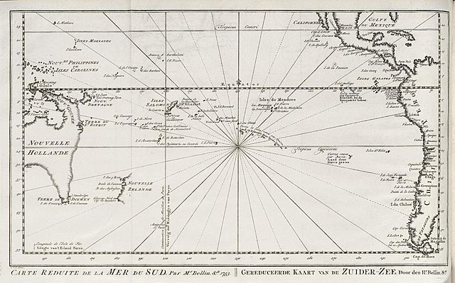
[edit]Nederlands: Kaart van de Stille Oceaan, met Australië en de westkust van Zuid-Amerika
English: Map of the Pacific Ocean, with Australia and the west coast of South America( |
||||||||||||||||||||||||||||||||||||||||||||||||||||||||||||||||
|---|---|---|---|---|---|---|---|---|---|---|---|---|---|---|---|---|---|---|---|---|---|---|---|---|---|---|---|---|---|---|---|---|---|---|---|---|---|---|---|---|---|---|---|---|---|---|---|---|---|---|---|---|---|---|---|---|---|---|---|---|---|---|---|---|
| Author |
Nederlands: Jacques Nicolas Bellin (landmeter / kaartenmaker), Jacobus van der Schley (direxit), Pierre d' Hondt (uitgever)
English: Jacques Nicolas Bellin (land surveyor / mapmaker), Jacobus van der Schley (direxit), Pierre d' Hondt (publisher) |
|||||||||||||||||||||||||||||||||||||||||||||||||||||||||||||||
| Title |
Nederlands: Kaart van de Stille Oceaan, met Australië en de westkust van Zuid-Amerika
English: Map of the Pacific Ocean, with Australia and the west coast of South America |
|||||||||||||||||||||||||||||||||||||||||||||||||||||||||||||||
| Description |
Nederlands: Kaart van de Stille Oceaan, met Australië en de westkust van Zuid-Amerika.
Carte Réduite de la Mer du Sud, Par Mr. Bellin, &a. 1753. Gereduceerde Kaart van de Zuider-Zee, Door den Hr. Bellin, &ca..English: Map of the Pacific Ocean, with Australia and the west coast of South America.
Carte Réduite de la Mer du Sud, Par Mr. Bellin, &a. 1753. Gereduceerde Kaart van de Zuider-Zee, Door den Hr. Bellin, &ca.. |
|||||||||||||||||||||||||||||||||||||||||||||||||||||||||||||||
| Date | circa 1757 | |||||||||||||||||||||||||||||||||||||||||||||||||||||||||||||||
| Medium |
Nederlands: gravure op papier
English: engraving on paper |
|||||||||||||||||||||||||||||||||||||||||||||||||||||||||||||||
| Dimensions | height: 26 cm (10.2 in); width: 16 cm (6.2 in) | |||||||||||||||||||||||||||||||||||||||||||||||||||||||||||||||
| Collection |
|
|||||||||||||||||||||||||||||||||||||||||||||||||||||||||||||||
| Accession number |
dl. XV, to. p. 371 |
|||||||||||||||||||||||||||||||||||||||||||||||||||||||||||||||
| Inscriptions |
Carte Réduite de la Mer du Sud / Gereduceerde Kaart van de Zuider-Zee
author: J.V.S. direx. |
|||||||||||||||||||||||||||||||||||||||||||||||||||||||||||||||
| Notes |
English: Subjects: chart / map / plan, compass / dial
Nederlands: Onderwerpen: plattegrond / kaart, kompas / windroos |
|||||||||||||||||||||||||||||||||||||||||||||||||||||||||||||||
| Source/Photographer |
|
|||||||||||||||||||||||||||||||||||||||||||||||||||||||||||||||
| Permission (Reusing this file) |
|
|||||||||||||||||||||||||||||||||||||||||||||||||||||||||||||||

File history
Click on a date/time to view the file as it appeared at that time.
| Date/Time | Thumbnail | Dimensions | User | Comment | |
|---|---|---|---|---|---|
| current | 15:10, 10 June 2014 | | 2,400 × 1,495 (586 KB) | HuskyBot (talk | contribs) | == {{int:filedesc}} == {{Artwork |title = {{nl|1=Kaart van de Stille Oceaan, met Australië en de westkust van Zuid-Amerika}} {{en|1=Map of the Pacific Ocean, with Australia and the west coast of South America}} |de... |
You cannot overwrite this file.
File usage on Commons
The following page uses this file:
File usage on other wikis
The following other wikis use this file:
- Usage on en.wikipedia.org
- Usage on es.wikipedia.org
- Usage on fr.wikipedia.org
Categories:
- Old maps of the Dutch East India Company
- Maps of the Dutch East India Company - Australia
- 1750s maps of Oceania
- 1757 in Oceania
- 18th-century maps of the Pacific Ocean
- Maps by Jakob van der Schley
- French-language maps
- Maps connecting Australia and New Guinea
- Maps connecting Australia and Tasmania
- 1750s maps of Australia
- 1750s maps of New Zealand