File:A Map of the Bishoprick of Durham - North from London - T. Badeslade delin. ; W. H. Toms sculpt. - btv1b53056773q.jpg
Jump to navigation
Jump to search

Size of this preview: 627 × 600 pixels. Other resolutions: 251 × 240 pixels | 502 × 480 pixels | 803 × 768 pixels | 1,071 × 1,024 pixels | 2,208 × 2,112 pixels.
Original file (2,208 × 2,112 pixels, file size: 824 KB, MIME type: image/jpeg)
Captions
Captions
Add a one-line explanation of what this file represents
Summary
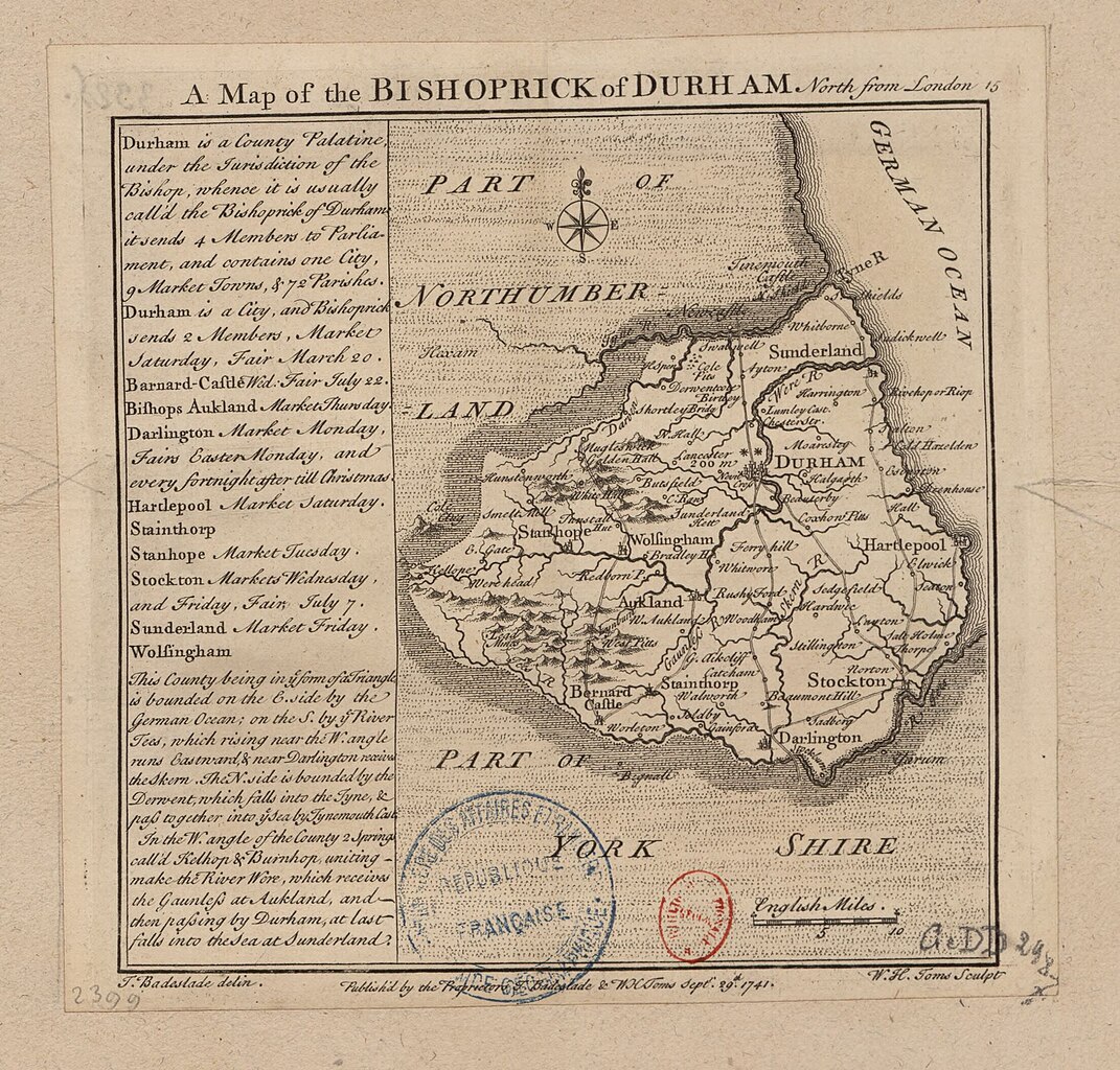
[edit]| A Map of the Bishoprick of Durham : North from London / T. Badeslade delin. ; W. H. Toms sculpt.
( |
|||||||||||||||||||||||||||
|---|---|---|---|---|---|---|---|---|---|---|---|---|---|---|---|---|---|---|---|---|---|---|---|---|---|---|---|
| Author |
Badeslade, Thomas (1718-1750). Cartographe Toms, William Henry (17..-17..). Graveur |
||||||||||||||||||||||||||
| Title |
A Map of the Bishoprick of Durham : North from London / T. Badeslade delin. ; W. H. Toms sculpt. |
||||||||||||||||||||||||||
| Description |
Français : Sujet : Durham, Evêché de
Échelle(s) : 10 English Miles [= 2,4 cm] Référence bibliographique : 188 Appartient à l’ensemble documentaire : AnvilEur Appartient à l’ensemble documentaire : MAEDI008 Appartient à l’ensemble documentaire : MAEDIGen0 Couverture : Royaume-Uni – Angleterre – Durham Langue : anglais Éditeur : Publish'd by the Proprietors T. Badeslade & W. H. Toms (London) |
||||||||||||||||||||||||||
| Date | 1742 | ||||||||||||||||||||||||||
| Dimensions | height: 16.5 cm (6.4 in); width: 16.5 cm (6.4 in) | ||||||||||||||||||||||||||
| Collection |
|
||||||||||||||||||||||||||
| References |
Français : Notice de recueil : http://catalogue.bnf.fr/ark:/12148/cb40577015h
Appartient à : Collection d'Anville ; 02399 Notice du catalogue : http://catalogue.bnf.fr/ark:/12148/cb41274746m Extrait de Chorographia Britanniae or A Set Maps of all Counties in England and Wales, 1742. |
||||||||||||||||||||||||||
| Source/Photographer |
Français : Bibliothèque nationale de France, département Cartes et plans, GE DD-2987 (2399)
Bibliothèque nationale de France |
||||||||||||||||||||||||||
| Permission (Reusing this file) |
|
||||||||||||||||||||||||||

File history
Click on a date/time to view the file as it appeared at that time.
| Date/Time | Thumbnail | Dimensions | User | Comment | |
|---|---|---|---|---|---|
| current | 03:42, 19 August 2022 | | 2,208 × 2,112 (824 KB) | Gzen92Bot (talk | contribs) | Gallica btv1b53056773q |
You cannot overwrite this file.
File usage on Commons
The following page uses this file: