File:A Post Medieval copper alloy token farthing for the Three Tun Tavern in Gracechurch Street (17th century). (FindID 262398).jpg
Jump to navigation
Jump to search

Size of this preview: 800 × 461 pixels. Other resolutions: 320 × 185 pixels | 640 × 369 pixels | 1,024 × 591 pixels | 1,574 × 908 pixels.
Original file (1,574 × 908 pixels, file size: 745 KB, MIME type: image/jpeg)
Captions
Captions
Add a one-line explanation of what this file represents
Summary
[edit]._(FindID_262398).jpg&action=edit§ion=1)
| A Post Medieval copper alloy token farthing for the Three Tun Tavern in Gracechurch Street (17th century). | |||
|---|---|---|---|
| Photographer |
Museum of London, Kate Sumnall, 2009-08-07 13:03:36 |
||
| Title |
A Post Medieval copper alloy token farthing for the Three Tun Tavern in Gracechurch Street (17th century). |
||
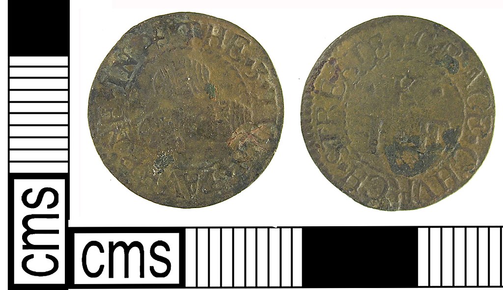
| Description |
English: A post medieval copper alloy trade token farthing from the Three Tun Tavern in Gracechurch Street, dating AD1648-1674. Boyne no. 961 (1858: 236).
Obverse: Three tuns Obverse inscription: THE 3 TVNN TAVERNE IN Reverse: IE K Reverse inscription: GRACE CHVRCH STREET Die axis measurement: 6.00 Dimensions: diameter: 15.47mm; weight: 0.58g. Reference: Boyne, W. 1858. Tokens issued in the seventeenth century. John Russell Smith: London. |
||
| Depicted place | (County of findspot) Greater London Authority | ||
| Date | between 1648 and 1674 | ||
| Accession number |
FindID: 262398 Old ref: LON-479745 Filename: Hyman - 17th token - Apr 09.jpg |
||
| Credit line |
|
||
| Source |
https://finds.org.uk/database/ajax/download/id/218645 Catalog: https://finds.org.uk/database/images/image/id/218645/recordtype/artefacts archive copy at the Wayback Machine Artefact: https://finds.org.uk/database/artefacts/record/id/262398 |
||
| Permission (Reusing this file) |
Attribution-ShareAlike License | ||
| Object location | | View this and other nearby images on: OpenStreetMap |
|---|
._(FindID_262398).jpg¶ms=051.494700_N_-000.225944_E_globe:Earth_class:object_type:object__&language=en)
Licensing
[edit]._(FindID_262398).jpg&action=edit§ion=2)
This file is licensed under the Creative Commons Attribution-Share Alike 2.0 Generic license.
Attribution: The Portable Antiquities Scheme/ The Trustees of the British Museum
- You are free:
- to share – to copy, distribute and transmit the work
- to remix – to adapt the work
- Under the following conditions:
- attribution – You must give appropriate credit, provide a link to the license, and indicate if changes were made. You may do so in any reasonable manner, but not in any way that suggests the licensor endorses you or your use.
- share alike – If you remix, transform, or build upon the material, you must distribute your contributions under the same or compatible license as the original.
File history
Click on a date/time to view the file as it appeared at that time.
| Date/Time | Thumbnail | Dimensions | User | Comment | |
|---|---|---|---|---|---|
| current | 17:18, 27 January 2017 | | 1,574 × 908 (745 KB) | Fæ (talk | contribs) | Portable Antiquities Scheme, LON, FindID: 262398, post medieval, page 168, batch count 2411 |
You cannot overwrite this file.
File usage on Commons
The following page uses this file:
._(FindID_262398).jpg)
._(FindID_262398).jpg&oldid=776486609)