File:A collection of maps, charts, drawings, surveys, etc, published from time to time, by order of the two houses of Congress - (United States, Western Hemisphere, and the world). LOC 2013591467-19.jpg
Jump to navigation
Jump to search

Size of this preview: 800 × 393 pixels. Other resolutions: 320 × 157 pixels | 640 × 315 pixels | 1,024 × 503 pixels | 1,280 × 629 pixels | 2,560 × 1,259 pixels | 8,899 × 4,375 pixels.
Original file (8,899 × 4,375 pixels, file size: 4.5 MB, MIME type: image/jpeg)
Captions
Captions
Add a one-line explanation of what this file represents
Summary
[edit]| Description |
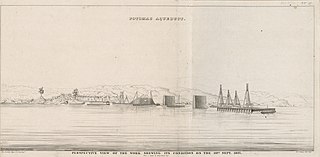
English: Relief shown by hachures and spot heights. Depths shown by soundings. Phillips 1384 "This is not a complete collection of the maps, charts, &c., published by order of Congress. It contains such only as could be collected when this volume was bound--1843." LC copy disbound. Available also through the Library of Congress Web site as a raster image. |
||
| Title | A collection of maps, charts, drawings, surveys, etc, published from time to time, by order of the two houses of Congress : [United States, Western Hemisphere, and the world]. | ||
| Shelf ID | G1200 U5 1843 | ||
| Parent | https://www.loc.gov/resource/g3700m.gct00284/ | ||
| Sheet title | Perspective view of the work. Shewing its condition on the 10th Sept. 1837 | ||
| Date | |||
| Source | https://www.loc.gov/item/2013591467/ | ||
| Author | United States. Congress | ||
| Permission (Reusing this file) |
|
||
| Other versions |
|
||
| Location | United States · Western Hemisphere | ||
| Part of | American Memory · General Maps · Catalog · Geography And Map Division | ||
| Subject | United States · Maps · Western Hemisphere · World Atlases |


._LOC_2013591467-19.jpg&action=edit§ion=1)
Licensing
[edit]._LOC_2013591467-19.jpg&action=edit§ion=2)
|
This is a faithful photographic reproduction of a two-dimensional, public domain work of art. The work of art itself is in the public domain for the following reason:
The official position taken by the Wikimedia Foundation is that "faithful reproductions of two-dimensional public domain works of art are public domain".
This photographic reproduction is therefore also considered to be in the public domain in the United States. In other jurisdictions, re-use of this content may be restricted; see Reuse of PD-Art photographs for details. | ||||
File history
Click on a date/time to view the file as it appeared at that time.
| Date/Time | Thumbnail | Dimensions | User | Comment | |
|---|---|---|---|---|---|
| current | 05:01, 20 May 2018 | | 8,899 × 4,375 (4.5 MB) | Fæ (talk | contribs) | LOC Maps https://www.loc.gov/item/2013591467/ sheet 19 of 198 #8755 |
You cannot overwrite this file.
File usage on Commons
The following page uses this file:
._LOC_2013591467-19.jpg&oldid=777984327)