File:A complete Post Medieval copper alloy trading token, 17th century AD. (FindID 278017).jpg
Jump to navigation
Jump to search

Size of this preview: 800 × 427 pixels. Other resolutions: 320 × 171 pixels | 640 × 341 pixels | 1,024 × 546 pixels | 1,878 × 1,002 pixels.
Original file (1,878 × 1,002 pixels, file size: 1.01 MB, MIME type: image/jpeg)
Captions
Captions
Add a one-line explanation of what this file represents
Summary
[edit].jpg&action=edit§ion=1)
| A complete Post Medieval copper alloy trading token, 17th century AD. | |||
|---|---|---|---|
| Photographer |
None, Felicity Winkley, 2010-01-15 15:22:46 |
||
| Title |
A complete Post Medieval copper alloy trading token, 17th century AD. |
||
| Description |
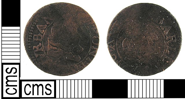
English: A post medieval copper alloy trade token dating AD1648-1674. The token is badly worn and therefore cannot be more accurately identified. It has been slightly mistruck so that the pellet border under or overlaps the outer edge of the token in places.
Obverse description: A man's bust facing right. Dimensions: diameter: 19.74mm; weight: 1.80g. |
||
| Depicted place | (County of findspot) Greater London Authority | ||
| Date | between 1648 and 1674 | ||
| Accession number |
FindID: 278017 Old ref: LON-BF6512 Filename: Ladbrook-Hutt - 17th token - Nov 09.jpg |
||
| Credit line |
|
||
| Source |
https://finds.org.uk/database/ajax/download/id/235064 Catalog: https://finds.org.uk/database/images/image/id/235064/recordtype/artefacts archive copy at the Wayback Machine Artefact: https://finds.org.uk/database/artefacts/record/id/278017 |
||
| Permission (Reusing this file) |
Attribution-ShareAlike License version 4.0 (verified 1 December 2020) | ||
| Object location | | View this and other nearby images on: OpenStreetMap |
|---|
.jpg¶ms=051.486100_N_-000.035250_E_globe:Earth_class:object_type:object__&language=en)
Licensing
[edit].jpg&action=edit§ion=2)
This file is licensed under the Creative Commons Attribution-Share Alike 4.0 International license.
Attribution: The Portable Antiquities Scheme/ The Trustees of the British Museum
- You are free:
- to share – to copy, distribute and transmit the work
- to remix – to adapt the work
- Under the following conditions:
- attribution – You must give appropriate credit, provide a link to the license, and indicate if changes were made. You may do so in any reasonable manner, but not in any way that suggests the licensor endorses you or your use.
- share alike – If you remix, transform, or build upon the material, you must distribute your contributions under the same or compatible license as the original.
File history
Click on a date/time to view the file as it appeared at that time.
| Date/Time | Thumbnail | Dimensions | User | Comment | |
|---|---|---|---|---|---|
| current | 16:04, 27 January 2017 | | 1,878 × 1,002 (1.01 MB) | Fæ (talk | contribs) | Portable Antiquities Scheme, LON, FindID: 278017, post medieval, page 150, batch count 2074 |
You cannot overwrite this file.
File usage on Commons
The following page uses this file:
.jpg)
.jpg&oldid=806788254)