File:A map of the British empire in America with the French, Spanish and the Dutch settlements adjacent thereto LOC 2003623107.jpg
Jump to navigation
Jump to search

Size of this preview: 600 × 600 pixels. Other resolutions: 240 × 240 pixels | 480 × 480 pixels | 768 × 768 pixels | 1,025 × 1,024 pixels | 2,049 × 2,048 pixels | 12,797 × 12,789 pixels.
Original file (12,797 × 12,789 pixels, file size: 25.72 MB, MIME type: image/jpeg)
Captions
Captions
Add a one-line explanation of what this file represents
Summary
[edit]| Warning | The original file is very high-resolution. It might not load properly or could cause your browser to freeze when opened at full size. |
|---|
| Description |
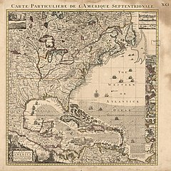
English: Relief shown pictorially. English and French. In upper right corner: XC.I. Second state, ca 1741. Phillips. Maps of America, p. 569. Available also through the Library of Congress Web site as a raster image. Includes 22 local area insets and notes. |
||
| Title | A map of the British empire in America with the French, Spanish and the Dutch settlements adjacent thereto | ||
| Shelf ID | G3300 1741 .P6 | ||
| Date | |||
| Source | https://www.loc.gov/item/2003623107/ | ||
| Author | Popple, Henry; Cóvens Et Mortier | ||
| Permission (Reusing this file) |
|
||
| Other versions |
|
||
| Location | North America · Great Britain · America | ||
| Part of | American Memory · General Maps · Catalog · Geography And Map Division | ||
| Subject | Early Maps · North America · Maps · Early Works To 1800 · Great Britain · Colonies · America |


Licensing
[edit]
|
This is a faithful photographic reproduction of a two-dimensional, public domain work of art. The work of art itself is in the public domain for the following reason:
The official position taken by the Wikimedia Foundation is that "faithful reproductions of two-dimensional public domain works of art are public domain".
This photographic reproduction is therefore also considered to be in the public domain in the United States. In other jurisdictions, re-use of this content may be restricted; see Reuse of PD-Art photographs for details. | ||||
File history
Click on a date/time to view the file as it appeared at that time.
| Date/Time | Thumbnail | Dimensions | User | Comment | |
|---|---|---|---|---|---|
| current | 15:27, 24 May 2018 | | 12,797 × 12,789 (25.72 MB) | Fæ (talk | contribs) | LOC Maps https://www.loc.gov/item/2003623107/ #14246 |
You cannot overwrite this file.
File usage on Commons
The following page uses this file: