File:A map of the United States of North America LOC 2015588795.jpg
Jump to navigation
Jump to search

Size of this preview: 703 × 600 pixels. Other resolutions: 281 × 240 pixels | 563 × 480 pixels | 900 × 768 pixels | 1,200 × 1,024 pixels | 2,400 × 2,048 pixels | 17,760 × 15,153 pixels.
Original file (17,760 × 15,153 pixels, file size: 34.51 MB, MIME type: image/jpeg)
Captions
Captions
Add a one-line explanation of what this file represents
Summary
[edit]| Warning | The original file is very high-resolution. It might not load properly or could cause your browser to freeze when opened at full size. |
|---|
| Description |
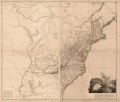
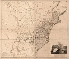
English: Relief shown by hachures. In lower margins: London. Published as the act directs by A. Arrowsmith, no 24 Rathbone Place, Jan. 1st, 1796. This is Tooley's 1802 (c) issue of the map. R.V. Tooley, Mapping of America, 1980, 79. Includes notes, including the 22 line boundary note, and illustration and text of Niagara Falls. LC copy assembled into two sheets with only top margin trimmed, each sheet sectioned into 3 pieces and mounted on cloth. Available also through the Library of Congress Web site as a raster image. |
||
| Title | A map of the United States of North America | ||
| Shelf ID | G3700 1802 .A6 | ||
| Date | |||
| Source | https://www.loc.gov/item/2015588795/ | ||
| Author | Arrowsmith, Aaron | ||
| Permission (Reusing this file) |
|
||
| Other versions |
|
||
| Location | United States | ||
| Part of | American Memory · General Maps · Catalog · Geography And Map Division | ||
| Subject | United States · Maps · Early Maps |

Licensing
[edit]
|
This is a faithful photographic reproduction of a two-dimensional, public domain work of art. The work of art itself is in the public domain for the following reason:
The official position taken by the Wikimedia Foundation is that "faithful reproductions of two-dimensional public domain works of art are public domain".
This photographic reproduction is therefore also considered to be in the public domain in the United States. In other jurisdictions, re-use of this content may be restricted; see Reuse of PD-Art photographs for details. | ||||
File history
Click on a date/time to view the file as it appeared at that time.
| Date/Time | Thumbnail | Dimensions | User | Comment | |
|---|---|---|---|---|---|
| current | 06:33, 7 June 2018 | | 17,760 × 15,153 (34.51 MB) | Fæ (talk | contribs) | LOC Maps https://www.loc.gov/item/2015588795/ #7340 |
You cannot overwrite this file.
File usage on Commons
The following page uses this file: