File:A new and correct map of the world, laid down according to the newest discoveries, and from the most exact observations. NYPL1630429.tiff
Aller à la navigation
Aller à la recherche

Taille de cet aperçu JPG pour ce fichier TIF : 800 × 482 pixels. Autres résolutions : 320 × 193 pixels | 640 × 386 pixels | 1 024 × 617 pixels | 1 280 × 771 pixels | 2 560 × 1 543 pixels | 6 528 × 3 934 pixels.
Fichier d’origine (6 528 × 3 934 pixels, taille du fichier : 73,5 Mio, type MIME : image/tiff)
Légendes
Légendes
Ajoutez en une ligne la description de ce que représente ce fichier
Description
[modifier]| Description | A new and correct map of the world, laid down according to the newest discoveries, and from the most exact observations. | |||||||||||||||||||||||
| Notes | To His most sacred Majesty George II, ... King of Great Britain, France & Ireland ... this map is humbly dedicated. | |||||||||||||||||||||||
| Standard reference | Variant of Phillips 554 | |||||||||||||||||||||||
| Item/Page/Plate | 1 | |||||||||||||||||||||||
| Physical description | 1 map : hand col. ; 64 x 101 cm., folded to 64 x 28 cm. | |||||||||||||||||||||||
| Catalog Call Number | Map Div. 97-6053[LHS 329; atlas cases] | |||||||||||||||||||||||
| Date | vers 1736 | |||||||||||||||||||||||
| Source |
http://digitalgallery.nypl.org/nypldigital/dgkeysearchdetail.cfm?imageID=1630429
|
|||||||||||||||||||||||
| Auteur | Moll, Herman, d. 1732 -- CartographerBowles, Thomas, 1694-1773 -- Bookseller | |||||||||||||||||||||||
| Autorisation (Réutilisation de ce fichier) |
From The Lionel Pincus & Princess Firyal Map Division. Released on a CC0 license.[1] | |||||||||||||||||||||||
| Source Description | 1 atlas (65 leaves (most folded)) : 31 maps (most hand col.) ; 65 cm. | |||||||||||||||||||||||
| Digital ID | 1630429 | |||||||||||||||||||||||
| Location | Stephen A. Schwarzman Building / The Lionel Pincus and Princess Firyal Map Division | |||||||||||||||||||||||
| NYPL digital item published | 5-12-2008; updated 1-9-2012 | |||||||||||||||||||||||

Conditions d’utilisation
[modifier]| Ce fichier est disponible selon les termes de la licence Creative Commons CC0 Don universel au domaine public. | |
| La personne qui a associé une œuvre avec cet acte l’a placée dans le domaine public en renonçant mondialement à tous ses droits sur cette œuvre en vertu des lois relatives au droit d’auteur, ainsi qu’à tous les droits juridiques connexes et voisins qu’elle possédait sur l’œuvre, sans autre limite que celles imposées par la loi. Vous pouvez copier, modifier, distribuer et utiliser cette œuvre, y compris à des fins commerciales, sans qu’il soit nécessaire d’en demander la permission.
|
The making of this file was supported by Wikimedia UK.
To see other files made with the support of Wikimedia UK, please see the category Supported by Wikimedia UK.
|
Historique du fichier
Cliquer sur une date et heure pour voir le fichier tel qu'il était à ce moment-là.
| Date et heure | Vignette | Dimensions | Utilisateur | Commentaire | |
|---|---|---|---|---|---|
| actuel | 4 mai 2014 à 06:59 |  | 6 528 × 3 934 (73,5 Mio) | Fæ (d | contributions) | crop (uploaded using chunked upload script) |
| 6 avril 2014 à 13:12 | 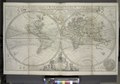 | 6 930 × 4 826 (95,69 Mio) | Fæ (d | contributions) | =={{int:filedesc}}== {{NYPL_map |source_description = 1 atlas (65 leaves (most folded)) : 31 maps (most hand col.) ; 65 cm. |standard_reference = Variant of Phillips 554 |record_id = 1767541 |catalog_call_number = Map Div. 97-6053[LHS 329; atlas cases]... |
Vous ne pouvez pas remplacer ce fichier.
Utilisations locales du fichier
Les 2 pages suivantes utilisent ce fichier :
Utilisations du fichier sur d’autres wikis
Les autres wikis suivants utilisent ce fichier :
- Utilisation sur fr.wikipedia.org