File:A new map of Nth. Carolina - with its canals, roads & distances from place to place, along the stage & steam boat routes. LOC 2012593329.jpg
Jump to navigation
Jump to search

Size of this preview: 800 × 487 pixels. Other resolutions: 320 × 195 pixels | 640 × 389 pixels | 1,024 × 623 pixels | 1,280 × 779 pixels | 2,560 × 1,558 pixels | 5,855 × 3,563 pixels.
Original file (5,855 × 3,563 pixels, file size: 3.66 MB, MIME type: image/jpeg)
Captions
Captions
Add a one-line explanation of what this file represents
Summary
[edit]| Description |
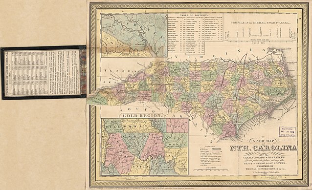
English: Relief shown by contours. Prime meridian: Washington. Cover title "N. Carolina" with "Population of North Carolina by Counties, in 1850" pasted on verso of front cover. "Entered according to Act of Congress in the year 1850 by Thomas Cowperthwait & Co. in the Clerks office of the District court of the Eastern District of Pennsylvania." Includes "Table of distances" and "Profile of the Dismal Swamp Canal." Insets: [Neuse River Region] -- Gold region. Available also through the Library of Congress Web site as a raster image. Signed on verso: Millard Fillmore March 1853. Annotations in red ink. LC copy imperfect: Darkened, fold-lined, and mounted on cloth backing. In lower right margin: 18. |
||
| Title | A new map of Nth. Carolina : with its canals, roads & distances from place to place, along the stage & steam boat routes. | ||
| Shelf ID | G3900 1853 .T4 | ||
| Date | |||
| Source | https://www.loc.gov/item/2012593329/ | ||
| Author | Thomas, Cowperthwait & Co. | ||
| Permission (Reusing this file) |
|
||
| Other versions |
|
||
| Location | Dismal Swamp Canal Region · United States · Virginia · North Carolina | ||
| Part of | American Memory · General Maps · Catalog · Geography And Map Division | ||
| Subject | Dismal Swamp Canal Region · Dismal Swamp Canal Region (N.C. And Va.) · North Carolina · United States · Maps · Roads · Canals |


Licensing
[edit]
|
This is a faithful photographic reproduction of a two-dimensional, public domain work of art. The work of art itself is in the public domain for the following reason:
The official position taken by the Wikimedia Foundation is that "faithful reproductions of two-dimensional public domain works of art are public domain".
This photographic reproduction is therefore also considered to be in the public domain in the United States. In other jurisdictions, re-use of this content may be restricted; see Reuse of PD-Art photographs for details. | ||||
File history
Click on a date/time to view the file as it appeared at that time.
| Date/Time | Thumbnail | Dimensions | User | Comment | |
|---|---|---|---|---|---|
| current | 18:22, 31 May 2018 | | 5,855 × 3,563 (3.66 MB) | Fæ (talk | contribs) | LOC Maps https://www.loc.gov/item/2012593329/ #1012 |
You cannot overwrite this file.
File usage on Commons
The following page uses this file: