File:Acadia 1604-1607 topographic map-fr.svg
Jump to navigation
Jump to search

Size of this PNG preview of this SVG file: 656 × 600 pixels. Other resolutions: 263 × 240 pixels | 525 × 480 pixels | 840 × 768 pixels | 1,120 × 1,024 pixels | 2,240 × 2,048 pixels | 700 × 640 pixels.
Original file (SVG file, nominally 700 × 640 pixels, file size: 422 KB)
Captions
Captions
Add a one-line explanation of what this file represents
Summary
[edit]| Description |
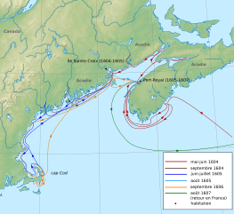
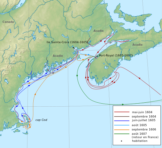
Français : Carte de l'Acadie entre 1604 et 1607, montrant les différentes expéditions de Samuel de Champlain et de Pierre Duguas de Mons et les deux habitations.
English: Map of Acadia between 1604 and 1607, showing the different expeditions by Samuel de Champlain and Pierre Dugua de Mons and also the habitations.
Català: Mapa d'Acadia entre 1604 i 1607, on es mostren les diferents expedicions de Samuel de Champlain i Pierre Duguas de Mons i els dos enclavaments. |
| Date | |
| Source |
File:New England and South-East of Canada topographic map-blank.svg |
| Author |
File:New England and South-East of Canada topographic map-blank.svg by User:Sémhur 2008-08-31
|
| Other versions |
|
| SVG development |


Licensing
[edit]
I, the copyright holder of this work, hereby publish it under the following license:
This file is licensed under the Creative Commons Attribution-Share Alike 3.0 Unported license.
- You are free:
- to share – to copy, distribute and transmit the work
- to remix – to adapt the work
- Under the following conditions:
- attribution – You must give appropriate credit, provide a link to the license, and indicate if changes were made. You may do so in any reasonable manner, but not in any way that suggests the licensor endorses you or your use.
- share alike – If you remix, transform, or build upon the material, you must distribute your contributions under the same or compatible license as the original.
File history
Click on a date/time to view the file as it appeared at that time.
| Date/Time | Thumbnail | Dimensions | User | Comment | |
|---|---|---|---|---|---|
| current | 15:40, 18 September 2023 | | 700 × 640 (422 KB) | Lalpino (talk | contribs) | File uploaded using svgtranslate tool (https://svgtranslate.toolforge.org/). Added translation for ca. |
| 15:30, 18 September 2023 |  | 700 × 640 (422 KB) | Lalpino (talk | contribs) | File uploaded using svgtranslate tool (https://svgtranslate.toolforge.org/). Added translation for ca. | |
| 17:53, 15 February 2022 |  | 700 × 640 (415 KB) | Εὐθυμένης (talk | contribs) | File uploaded using svgtranslate tool (https://svgtranslate.toolforge.org/). Added translation for el. | |
| 00:12, 27 September 2011 |  | 700 × 640 (412 KB) | Dr Wilson (talk | contribs) | Noms des colonies, cap Cod | |
| 22:07, 26 September 2011 |  | 700 × 640 (409 KB) | Dr Wilson (talk | contribs) |
You cannot overwrite this file.
File usage on Commons
The following 4 pages use this file:
File usage on other wikis
The following other wikis use this file:
- Usage on ca.wikipedia.org
- Usage on es.wikipedia.org
- Usage on fr.wikipedia.org
- Usage on gl.wikipedia.org
- Usage on nds.wikipedia.org
- Usage on uk.wikipedia.org