File:Admiralty Chart No 2533 Ruapuke Island (16557355366), Published 1857.jpg

Original file (4,352 × 2,669 pixels, file size: 2.95 MB, MIME type: image/jpeg)
Captions
Captions
Summary[edit]
,_Published_1857.jpg&action=edit§ion=1)
| Description |
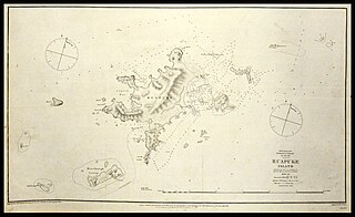
After proclaiming British sovereignty over Rakiura (Stewart Island) by right of discovery, Thomas Bunbury sailed north to Ruapuke Island on the HMS Herald. According to T. Lindsay Buick, they arrived on 9 June 1840. Ruapuke Island was the home of prominent Ngāi Tahu rangatira, Hone (Jack) Tuhawaiki, who came aboard the Herald in a full dress staff uniform of a British aide de camp, with gold lace trousers and cocked hat and plume. He signed the Herald Sheet of te Tiriti o Waitangi, either on the night of 9 June, or the next morning (10 June). His name was recorded as John Touwaick: www.flickr.com/photos/archivesnz/12195648904. Two other rangatira, recorded as Kaikoura and Taiaroa, signed on 10 June. This is a chart of Ruapuke Island, surveyed and published by the British Admiralty, Chart No 2533. Zoom or download to enlarge. Surveyed by Capt. J.L. Stokes and the officers of H.M.S. Acheron 1849-50 Archives Reference: ADOE 16621 MW676 Box 1/11B 2542 (detail) This record is part of #Waitangi175, celebrating 175 years since the signing of of te Tiriti o Waitangi. You can see other real time tweets on Twitter (twitter.com/ArchivesNZ), or explore the Waitangi 175 album here on Flickr. Material from Archives New Zealand Caption information from T.Lindsay Buick, ‘The Treaty of Waitangi’ |
| Date | |
| Source | Chart of Ruapuke Island |
| Author | Archives New Zealand from New Zealand |
Licensing[edit]
,_Published_1857.jpg&action=edit§ion=2)
- You are free:
- to share – to copy, distribute and transmit the work
- to remix – to adapt the work
- Under the following conditions:
- attribution – You must give appropriate credit, provide a link to the license, and indicate if changes were made. You may do so in any reasonable manner, but not in any way that suggests the licensor endorses you or your use.
- share alike – If you remix, transform, or build upon the material, you must distribute your contributions under the same or compatible license as the original.
| This image was originally posted to Flickr by Archives New Zealand at https://flickr.com/photos/35759981@N08/16557355366. It was reviewed on 8 September 2016 by FlickreviewR and was confirmed to be licensed under the terms of the cc-by-sa-2.0. |
File history
Click on a date/time to view the file as it appeared at that time.
| Date/Time | Thumbnail | Dimensions | User | Comment | |
|---|---|---|---|---|---|
| current | 21:12, 8 September 2016 | | 4,352 × 2,669 (2.95 MB) | Vanished Account Byeznhpyxeuztibuo (talk | contribs) | Transferred from Flickr via Flickr2Commons |
You cannot overwrite this file.
File usage on Commons
The following page uses this file:
- File:Chart of Ruapuke Island (16557355366).jpg (file redirect)
.jpg&redirect=no)
,_Published_1857.jpg&oldid=865384508)