File:Admiralty Chart No 2588 Porirua Harbour and Mana Island, 1858 (16717578411), Published 1858.jpg

Original file (3,413 × 2,277 pixels, file size: 1.28 MB, MIME type: image/jpeg)
Captions
Captions
Summary[edit]
,_Published_1858.jpg&action=edit§ion=1)
| Description |
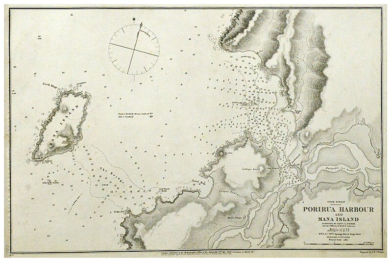
On 19 June 1840 the HMS Herald, having gathered signatures in Te Waipounamu (South Island), arrived near Kāpiti Island. Thomas Bunbury had special instructions from William Hobson to gain the signature of paramount Ngāti Toa rangatira, Te Rauparaha. Luckily for Bunbury, Te Rauparaha had just left Kāpiti for Mana Island and crossed paths with the Herald. Te Rauparaha explained that he had already signed the Cook Strait sheet (www.flickr.com/photos/archivesnz/15964612413), and that two other rangatira, Te Rangihaeata (www.flickr.com/photos/archivesnz/18289199718) and Te Hiko, were at Mana. So the Herald was put about and sailed to Mana Island. Here Te Rauparaha and Edward Williams accompanied Bunbury on shore, where they found Te Rangihaeata, but Te Hiko was absent on an expedition to the mainland. No record appears to have been preserved of the negotiations which followed. Bunbury wrote later that 'the chief Rangihaeata, after some time, returned with us on board, accompanied by Rauparaha, when both signed the [Herald Sheet of the] treaty.’ Te Rauparaha therefore signed te Tiriti o Waitangi twice, on two different sheets. This 1850 chart of Mana Island and Porirua Harbour was created by the British Admiralty survey ship, HMS Acheron, and published in 1858. Zoom or download to enlarge. Surveyed by Capt J.L. Stokes and the officers of H.M.S. Acheron Archives Reference: MW676 Box 1/ 5B/ 2588 archway.archives.govt.nz/ViewFullItem.do?code=21488142 This record is part of #Waitangi175, celebrating 175 years since the signing of of te Tiriti o Waitangi. You can see other real time tweets on Twitter (twitter.com/ArchivesNZ), or explore the Waitangi 175 album here on Flickr. Material supplied by Archives New Zealand Caption information from T. Lindsay Buick, ‘The Treaty of Waitangi’ |
||||||||||
| Date | |||||||||||
| Source | Porirua Harbour and Mana Island, 1858. From: Archives New Zealand from New Zealand | ||||||||||
| Creator |
|
||||||||||
| Geotemporal data | |||||||||||
| Bounding box |
|
||||||||||
| Georeferencing | |||||||||||
Licensing[edit]
,_Published_1858.jpg&action=edit§ion=2)
- You are free:
- to share – to copy, distribute and transmit the work
- to remix – to adapt the work
- Under the following conditions:
- attribution – You must give appropriate credit, provide a link to the license, and indicate if changes were made. You may do so in any reasonable manner, but not in any way that suggests the licensor endorses you or your use.
- share alike – If you remix, transform, or build upon the material, you must distribute your contributions under the same or compatible license as the original.
| This image was originally posted to Flickr by Archives New Zealand at https://flickr.com/photos/35759981@N08/16717578411. It was reviewed on 8 September 2016 by FlickreviewR and was confirmed to be licensed under the terms of the cc-by-sa-2.0. |
File history
Click on a date/time to view the file as it appeared at that time.
| Date/Time | Thumbnail | Dimensions | User | Comment | |
|---|---|---|---|---|---|
| current | 21:12, 8 September 2016 | | 3,413 × 2,277 (1.28 MB) | Vanished Account Byeznhpyxeuztibuo (talk | contribs) | Transferred from Flickr via Flickr2Commons |
You cannot overwrite this file.
File usage on Commons
The following page uses this file:
- File:Porirua Harbour and Mana Island, 1858 (16717578411).jpg (file redirect)
.jpg&redirect=no)
,_Published_1858.jpg&oldid=865384966)