File:Admiralty Chart No 3279 (half) Hong Kong Waters East, Published 1903.jpg
Jump to navigation
Jump to search

Size of this preview: 476 × 600 pixels. Other resolutions: 190 × 240 pixels | 381 × 480 pixels | 609 × 768 pixels | 812 × 1,024 pixels | 1,625 × 2,048 pixels | 6,579 × 8,292 pixels.
Original file (6,579 × 8,292 pixels, file size: 16.15 MB, MIME type: image/jpeg)
Captions
Captions
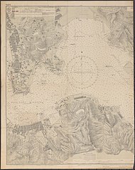
Nautical chart of Hong Kong Waters East
Summary[edit]
_Hong_Kong_Waters_East,_Published_1903.jpg&action=edit§ion=1)
| Description |
English: Nautical chart of Hong Kong Waters East. The scan is of the westernhalf of the chartNot current - not to be used for navigation! |
||||||||||
| Date | |||||||||||
| Source | https://nla.gov.au/nla.obj-229820835 | ||||||||||
| Author |
|
||||||||||
Licensing[edit]
_Hong_Kong_Waters_East,_Published_1903.jpg&action=edit§ion=2)
This work created by the United Kingdom Government is in the public domain.
This is because it is one of the following:
HMSO has declared that the expiry of Crown Copyrights applies worldwide (ref: HMSO Email Reply)
|
 |
File history
Click on a date/time to view the file as it appeared at that time.
| Date/Time | Thumbnail | Dimensions | User | Comment | |
|---|---|---|---|---|---|
| current | 08:44, 2 April 2020 | | 6,579 × 8,292 (16.15 MB) | Kognos (talk | contribs) | Uploaded a work by Hydrographic Office of the Admiralty from https://nla.gov.au/nla.obj-229820835 with UploadWizard |
You cannot overwrite this file.
File usage on Commons
There are no pages that use this file.
_Hong_Kong_Waters_East,_Published_1903.jpg&oldid=864330192)