File:Admiralty Chart No 783 Mayham, with a View, Published 1782.jpg
Jump to navigation
Jump to search

Size of this preview: 467 × 599 pixels. Other resolutions: 187 × 240 pixels | 374 × 480 pixels | 598 × 768 pixels | 798 × 1,024 pixels | 1,596 × 2,048 pixels | 4,218 × 5,412 pixels.
Original file (4,218 × 5,412 pixels, file size: 4.96 MB, MIME type: image/jpeg)
Captions
Captions
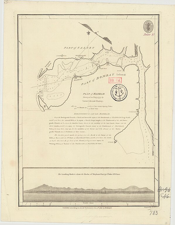
Plan of Mahim, with leading mark to clear the rock
Summary[edit]
| Description |
English: Plan of Mayham (Mahim), surveyed in May 1777 by Lieut. Edward Harvey. The Leading mark to clear the rocks off Mayham by Lt John Mc Cluer. Not current - not to be used for navigation! |
||||||||||||||||||||||||||
| Date | |||||||||||||||||||||||||||
| Source |
|
||||||||||||||||||||||||||
| Author |
|
||||||||||||||||||||||||||

Licensing[edit]
This work created by the United Kingdom Government is in the public domain.
This is because it is one of the following:
HMSO has declared that the expiry of Crown Copyrights applies worldwide (ref: HMSO Email Reply)
|
 |
File history
Click on a date/time to view the file as it appeared at that time.
| Date/Time | Thumbnail | Dimensions | User | Comment | |
|---|---|---|---|---|---|
| current | 22:22, 22 March 2024 | | 4,218 × 5,412 (4.96 MB) | Kognos (talk | contribs) | Uploaded a work by {{Creator:United Kingdom Hydrographic Office}} from {{Institution:Bibliothèque nationale de France}} with UploadWizard |
You cannot overwrite this file.
File usage on Commons
The following page uses this file: