File:Aeolian Islands.jpg
跳转到导航
跳转到搜索

本预览的尺寸:396 × 599像素。 其他分辨率:159 × 240像素 | 317 × 480像素 | 508 × 768像素 | 677 × 1,024像素 | 2,032 × 3,072像素。
原始文件 (2,032 × 3,072像素,文件大小:610 KB,MIME类型:image/jpeg)
说明
说明
添加一行文字以描述该文件所表现的内容
摘要[编辑]
| 描述 |
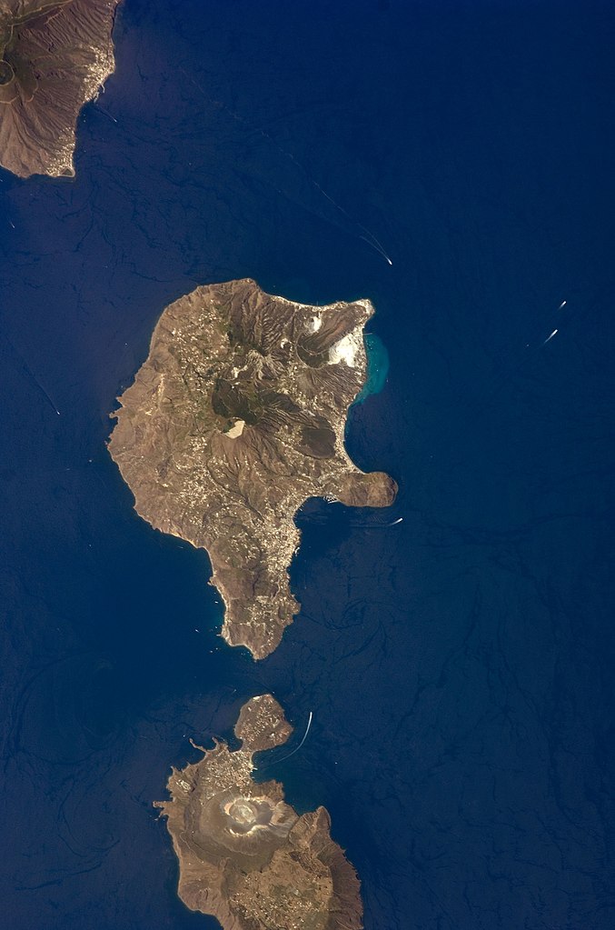
English: This detailed astronaut photograph features Lipari Island and the northern portion of Vulcano Island. Tan, speckled areas on both islands are urban areas and towns. Lipari is the largest of the Aeolian Islands, and it is a popular tourist destination due to its rugged volcanic topography and beaches (several boat wakes are visible around the islands). White pumice beaches and caves are located along the northern and northeastern coastlines of Lipari; black sand beaches derived from lava flows can also be found on the island. The most recent eruptive activity on Lipari took place from approximately AD 580–729.
|
||||||||||||||||||||||||||||||||||||||||||||||||||
| 日期 | |||||||||||||||||||||||||||||||||||||||||||||||||||
| 来源 | NASA Earth Observatory | ||||||||||||||||||||||||||||||||||||||||||||||||||
| 作者 | This image was taken by the NASA Expedition 17 crew. | ||||||||||||||||||||||||||||||||||||||||||||||||||
| 相机位置 | | 在以下服务上查看本图像和附近其他图像: OpenStreetMap |
|---|
本图像或视频收录于美国国家航空航天局 (NASA)休斯顿太空中心(Johnson Space Center),其照片编号是: ISS017-E-9777 此标签不表示文件的著作权状态。任何文件在附有此标签的同時还需要一个有效的著作权标签。请参阅许可协议说明页面以了解更多信息。 其他语言:
|
This photograph was acquired with a Nikon D2Xs digital camera fitted with a 400 mm lens, and is provided by the ISS Crew Earth Observations experiment and the Image Science & Analysis Laboratory, Johnson Space Center.
许可协议[编辑]
| 本文件完全由NASA创作,在美国属于公有领域。根据NASA的版权方针,NASA的材料除非另有声明否则不受版权保护。(参见Template:PD-USGov/zh、NASA版权方针页面或JPL图片使用方针。) | ||
 |
警告:
|
文件历史
点击某个日期/时间查看对应时刻的文件。
| 日期/时间 | 缩略图 | 大小 | 用户 | 备注 | |
|---|---|---|---|---|---|
| 当前 | 2013年11月15日 (五) 01:45 | | 2,032 × 3,072(610 KB) | Rotatebot(留言 | 贡献) | Bot: Image rotated by 90° |
| 2011年5月4日 (三) 17:07 |  | 3,072 × 2,039(555 KB) | Originalwana(留言 | 贡献) | higher res | |
| 2009年5月23日 (六) 16:23 |  | 939 × 586(115 KB) | Originalwana(留言 | 贡献) | {{Information |Description={{en|1=This detailed astronaut photograph features Lipari Island and the northern portion of Vulcano Island. Tan, speckled areas on both islands are urban areas and towns. Lipari is the largest of the Aeolian Islands, and it is |
您不可以覆盖此文件。
文件用途
以下4个页面使用本文件:
全域文件用途
以下其他wiki使用此文件:
- ar.wikipedia.org上的用途
- ast.wikipedia.org上的用途
- ca.wikipedia.org上的用途
- ceb.wikipedia.org上的用途
- cy.wikipedia.org上的用途
- de.wikivoyage.org上的用途
- el.wikipedia.org上的用途
- en.wikipedia.org上的用途
- en.wikivoyage.org上的用途
- es.wikipedia.org上的用途
- eu.wikipedia.org上的用途
- fr.wikivoyage.org上的用途
- gl.wikipedia.org上的用途
- he.wikivoyage.org上的用途
- hr.wikipedia.org上的用途
- id.wikipedia.org上的用途
- it.wikipedia.org上的用途
- it.wikivoyage.org上的用途
- ko.wikipedia.org上的用途
- lb.wikipedia.org上的用途
- nl.wikipedia.org上的用途
- ro.wikipedia.org上的用途
- sl.wikipedia.org上的用途
- www.wikidata.org上的用途
- zh-yue.wikipedia.org上的用途
- zh.wikipedia.org上的用途
元数据
分类:
- ISS Expedition 17 Crew Earth Observations
- Satellite pictures of Aeolian Islands in 2008
- Satellite pictures of Lipari
- Vulcano Island
- Satellite pictures of volcanoes
- Submarine volcanism of Italy
- Submarine plumes
- Vulcanello
- Nested calderas of Vulcano Island
- La Fossa Caldera
- Piano Caldera
- La Fossa crater (Vulcano)
- Satellite pictures of Vulcano Island
- Nested calderas in Italy