File:Alamannien Hochburgund ca 1000.png
跳至導覽
跳至搜尋
預覽大小:711 × 599 像素。 其他解析度:285 × 240 像素 | 570 × 480 像素 | 911 × 768 像素 | 1,215 × 1,024 像素 | 2,500 × 2,107 像素。
原始檔案 (2,500 × 2,107 像素,檔案大小:1.11 MB,MIME 類型:image/png)
說明
說明
添加單行說明來描述出檔案所代表的內容
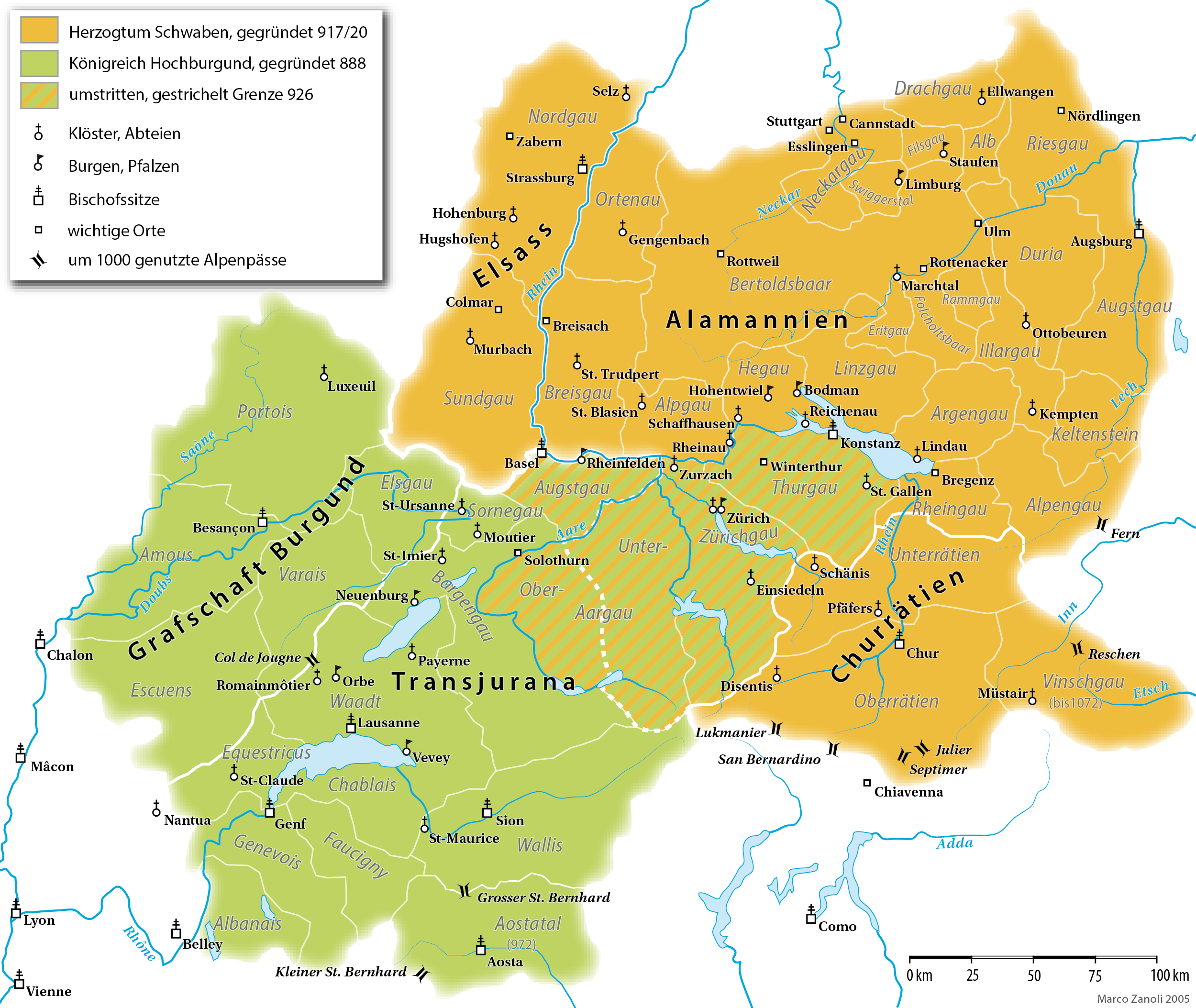
Map of the Duchy of Swabia and the Kingdom of Upper Burgundy in the 10th/11th century
摘要
[編輯]| 描述 |
English: A map (in German) of the Duchy of Alamannia and the Kingdom of Upper Burgundy in the 10th century. |
| 日期 | |
| 來源 | own work; G. Droysen: Allgemeiner Historischer Handatlas. Bielefeld / Leipzig, 1886, 22f. |
| 作者 | Marco Zanoli |
| 其他版本 |
|


|
本圖片是以PNG、GIF或JPEG格式上傳。然而,其中包含的資料或訊息,應該重新建立成可縮放向量圖形(SVG)檔案,以更有效率或更準確的方式儲存。如有可能,請上傳本圖片的SVG格式版本。在上傳之後,請修改維基各姊妹計畫中所有使用舊版圖片的條目(列在圖像連結章節中),替換為新版圖片,並在舊圖片的描述頁中加入{{Vector version available|新圖片名稱.svg}}模板,同時移除本模板。
|
授權條款
[編輯]
You may use my work outside wikipedia for free as long as you name me as the author. If you would like to use my work in a print medium, please send me a specimen copy.
Contact me if you have questions regarding the license or if you want individual changes to the map (marco.zanoli at hotmail.ch). 此檔案採用創用CC 姓名標示-相同方式分享 4.0 國際授權條款。 姓名標示: Marco Zanoli
|
檔案歷史
點選日期/時間以檢視該時間的檔案版本。
| 日期/時間 | 縮圖 | 尺寸 | 使用者 | 備註 | |
|---|---|---|---|---|---|
| 目前 | 2021年4月10日 (六) 16:49 | | 2,500 × 2,107(1.11 MB) | Sidonius(留言 | 貢獻) | Lukmanier und San Bernardino vertauscht |
| 2021年3月28日 (日) 14:11 |  | 2,500 × 2,107(1.12 MB) | Sidonius(留言 | 貢獻) | kleinere Korrekturen, Gaue auch in Hochburgund in modernen Namen | |
| 2020年11月15日 (日) 18:49 |  | 1,500 × 1,319(550 KB) | FootKalos1597(留言 | 貢獻) | Added informations | |
| 2019年2月19日 (二) 08:08 |  | 1,500 × 1,319(534 KB) | Sidonius(留言 | 貢獻) | - Chiavenna entfernt, da erst 1157 zu Schwaben | |
| 2019年2月18日 (一) 16:15 |  | 1,500 × 1,319(535 KB) | Sidonius(留言 | 貢獻) | - Kloster St-Claude eingezeichnet - Beschriftung weiss hinterlegt - Vinschgau übereinstimmend mit Forschung zu Churrätien als Teil des Hzm. Schwaben eingezeichnet | |
| 2019年1月20日 (日) 13:24 |  | 1,500 × 1,319(414 KB) | Sidonius(留言 | 貢獻) | - Abtei Hugshofen eingezeichnet - Aostatal als Teil von Hochburgund | |
| 2019年1月13日 (日) 14:22 |  | 1,500 × 1,285(404 KB) | Sidonius(留言 | 貢獻) | weitere Fehler korrigiert, zusätzliche Orte eingezeichnet, Legende überarbeitet, Grenzen korrigiert gemäss Historischem Lexikon der CH | |
| 2019年1月12日 (六) 15:36 |  | 1,500 × 1,288(392 KB) | Sidonius(留言 | 貢獻) | kleinere Fehler behoben in Beschriftungen, Farben noch etwas angepasst | |
| 2012年11月26日 (一) 23:10 |  | 1,500 × 1,322(252 KB) | Hawky.diddiz(留言 | 貢獻) | Lossless optimization | |
| 2011年5月23日 (一) 11:54 |  | 1,500 × 1,322(433 KB) | Sidonius(留言 | 貢獻) | letzter Versuch, die korrigierte Datei einzubinden |
無法覆蓋此檔案。
檔案用途
下列15個頁面有用到此檔案:
- Atlas of Switzerland
- Maps of Switzerland
- User:J budissin/Uploads/BiH/2019 February 10-18
- User:J budissin/Uploads/BiH/2019 February 19-28
- User:J budissin/Uploads/BiH/2019 January 11-20
- User:Magog the Ogre/Multilingual legend/2020 November 11-20
- User:Magog the Ogre/Multilingual legend/2021 April 1-10
- User:Magog the Ogre/Multilingual legend/2021 March 21-31
- User:Sidonius
- User:Zinneke/Nei Biller iwwer Lëtzebuerg/2020 November 11-20
- File:Souabe et Haute-Bourgogne.png
- File:Souabe et Haute-Bourgogne.svg
- File:Souabe et Haute-Bourgogne1.png
- File talk:Heiliges Römisches Reich 1000.PNG
- Category:Duchy of Swabia
全域檔案使用狀況
以下其他 wiki 使用了這個檔案:
- als.wikipedia.org 的使用狀況
- an.wikipedia.org 的使用狀況
- ar.wikipedia.org 的使用狀況
- arz.wikipedia.org 的使用狀況
- ast.wikipedia.org 的使用狀況
- bg.wikipedia.org 的使用狀況
- br.wikipedia.org 的使用狀況
- ca.wikipedia.org 的使用狀況
- cs.wikipedia.org 的使用狀況
- cy.wikipedia.org 的使用狀況
- de.wikipedia.org 的使用狀況
檢視此檔案的更多全域使用狀況。