File:Alaska pipeline route near Valdez River.jpg
ナビゲーションに移動
検索に移動

このプレビューのサイズ: 800 × 537 ピクセル。 その他の解像度: 320 × 215 ピクセル | 640 × 429 ピクセル | 1,024 × 687 ピクセル | 1,280 × 859 ピクセル | 2,898 × 1,944 ピクセル。
元のファイル (2,898 × 1,944 ピクセル、ファイルサイズ: 1.09メガバイト、MIME タイプ: image/jpeg)
キャプション
キャプション
このファイルの内容を1行で記述してください
この画像には画像編集が施されています。原本に対して次のデジタル的な変更が行われました。
|
| 解説 |
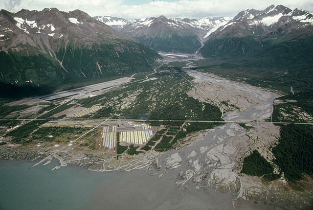
The following is the author's description of the photograph quoted directly from the photograph's Flickr page. "Original Caption: View Northeast Across Valdez River Floodplain Showing Pipe Storage Yard, Center Foreground, Which Holds 418 Miles of Pipe Yards at Fairbanks and Prudhoe Bay Hold 238 and 168 Miles of Pipe Respectively. The Community's Airport, Paved in the Summer of 1974 Sits at the Base of West Peak (Elevation 5,255 Feet). Mile 788, near the Alaska Pipeline Route 08/1974 U.S. National Archives%u2019 Local Identifier: 412-DA-13233 Photographer: Cowals, Dennis, 1945- Subjects: Alaska (United States) state Environmental Protection Agency Project DOCUMERICA Persistent URL: https://arcweb.archives.gov/arc/action/ExternalIdSearch?id=555685 Repository: Still Picture Records Section, Special Media Archives Services Division (NWCS-S), National Archives at College Park, 8601 Adelphi Road, College Park, MD, 20740-6001. For information about ordering reproductions of photographs held by the Still Picture Unit, visit: www.archives.gov/research/order/still-pictures.html Reproductions may be ordered via an independent vendor. NARA maintains a list of vendors at www.archives.gov/research/order/vendors-photos-maps-dc.html Access Restrictions: Unrestricted Use Restrictions: Unrestricted " |
||
| 日付 | |||
| 原典 |
originally posted to Flickr as View Northeast Across Valdez River Floodplain Showing Pipe Storage Yard, Center Foreground, Which Holds 418 Miles of Pipe Yards at Fairbanks and Prudhoe Bay Hold 238 and 168 Miles of Pipe Respectively...08/1974
|
||
| 作者 | [1] | ||
| 許可 (ファイルの再利用) |
このファイルはクリエイティブ・コモンズ 表示 2.0 一般ライセンスのもとに利用を許諾されています。
|
| 注釈 | この画像には注釈がついています: コモンズで注釈を見る |
ファイルの履歴
過去の版のファイルを表示するには、その版の日時をクリックしてください。
| 日付と時刻 | サムネイル | 寸法 | 利用者 | コメント | |
|---|---|---|---|---|---|
| 現在の版 | 2011年7月2日 (土) 01:43 | | 2,898 × 1,944 (1.09メガバイト) | Hohum (トーク | 投稿記録) | Cropped, levels |
| 2009年11月16日 (月) 05:36 |  | 3,000 × 2,048 (1.08メガバイト) | Geo Swan (トーク | 投稿記録) | {{Information |Description=The following is the author's description of the photograph quoted directly from the photograph's Flickr page.<br/>"'''Original Caption:''' View Northeast Across Valdez River Floodplain Showing Pipe Storage Yard, Center Foregrou |
このファイルは上書きできません。
ファイルの使用状況
以下のページがこのファイルを使用しています:
グローバルなファイル使用状況
以下に挙げる他のウィキがこの画像を使っています:
- arz.wikipedia.org での使用状況
- ceb.wikipedia.org での使用状況
- de.wikipedia.org での使用状況
- en.wikipedia.org での使用状況
- en.wikivoyage.org での使用状況
- fa.wikipedia.org での使用状況
- id.wikipedia.org での使用状況
- it.wikipedia.org での使用状況
- ja.wikipedia.org での使用状況
- pl.wikipedia.org での使用状況
- ru.wikipedia.org での使用状況
- tg.wikipedia.org での使用状況
- www.wikidata.org での使用状況