File:Algarve de Além-Mar.svg
Jump to navigation
Jump to search

Size of this PNG preview of this SVG file: 737 × 600 pixels. Other resolutions: 295 × 240 pixels | 590 × 480 pixels | 944 × 768 pixels | 1,258 × 1,024 pixels | 2,516 × 2,048 pixels | 1,306 × 1,063 pixels.
Original file (SVG file, nominally 1,306 × 1,063 pixels, file size: 619 KB)
Captions
Captions
Add a one-line explanation of what this file represents
| Description |
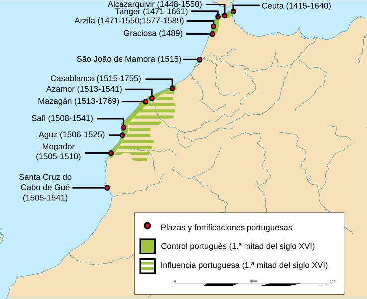
Español: "Algarve de Além-Mar". Presencia portuguesa en la costa atlántica del Magreb (siglo XV-siglo XVIII). English: Portuguese presence in the North African Atlantic Coast (15th-18th centuries). |
| Date | |
| Source |
Own work adapted from File:Morocco location map.svg by Eric Gaba (Sting) & File:Portuguese Morocco.PNG by Omar-Toons |
| Author | Asqueladd |
| Permission (Reusing this file) |
I, the copyright holder of this work, hereby publish it under the following license: This file is licensed under the Creative Commons Attribution-Share Alike 3.0 Unported license.
|
File history
Click on a date/time to view the file as it appeared at that time.
| Date/Time | Thumbnail | Dimensions | User | Comment | |
|---|---|---|---|---|---|
| current | 10:54, 26 April 2017 | | 1,306 × 1,063 (619 KB) | Rowanwindwhistler (talk | contribs) | Fake text added for better rendering |
| 07:38, 22 July 2016 |  | 1,225 × 997 (256 KB) | Rowanwindwhistler (talk | contribs) | Font fix | |
| 07:36, 22 July 2016 |  | 1,225 × 997 (256 KB) | Rowanwindwhistler (talk | contribs) | Text is now real text (editable), coast, river & land colour from https://en.wikipedia.org/wiki/Wikipedia:WikiProject_Maps/Conventions Scale added from the source map. | |
| 14:06, 30 November 2015 |  | 1,225 × 997 (505 KB) | Asqueladd (talk | contribs) | fix | |
| 13:52, 30 November 2015 |  | 1,223 × 995 (485 KB) | Asqueladd (talk | contribs) | {{Information |description={{es|1=''"Algarve de Além-Mar"''. Presencia portuguesa en la costa atlántica del Magreb (siglo XV-siglo XVIII).}}{{en|1=Portuguese presence in the North African Atlantic Coast (15th-18th centuries).}} |date=2015 |source={{o... |
You cannot overwrite this file.
File usage on Commons
There are no pages that use this file.
File usage on other wikis
The following other wikis use this file:
- Usage on ast.wikipedia.org
- Usage on en.wikipedia.org
- Usage on es.wikipedia.org
- Usage on it.wikipedia.org
- Usage on nl.wikipedia.org
- Usage on ru.wikipedia.org
- Usage on uk.wikipedia.org