File:Alluvial zone Broc Delta 01.jpg
Jump to navigation
Jump to search

Size of this preview: 800 × 329 pixels. Other resolutions: 320 × 132 pixels | 640 × 263 pixels | 1,024 × 421 pixels | 1,280 × 527 pixels | 2,560 × 1,053 pixels | 6,911 × 2,844 pixels.
Original file (6,911 × 2,844 pixels, file size: 6.16 MB, MIME type: image/jpeg)
Captions
Captions
Add a one-line explanation of what this file represents
Summary[edit]
| Description |
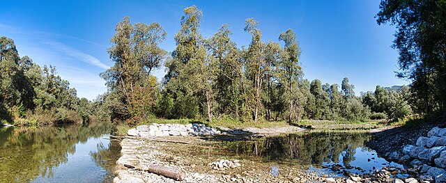
Deutsch: Das Delta bei der Mündung des Jaunbaches in den Greyerzersee in Broc ist Lebensraum für einen großen Erlenwald. Gut sichtbar ist das fliessende Wasser des Jaunbachs (links) und das Altwasser, das seit dem letzten Hochwasser zurückgeblieben ist.
Français : Le delta à l'embouchure de la Jogne dans le lac de la Gruyère à Broc est l'habitat d'une grande aulnaie. On voit bien l'eau courante de la Jogne (à gauche) et l'eau ancienne (à droite) qui est restée depuis la dernière crue.
English: The delta where the Jongn flows into Lake Gruyère in Broc is the habitat of a large alder forest. The flowing water of the Jaunbach (left) and the oxbow lake (right), which has remained since the last flood, are clearly visible. |
||
| Protected |
|
||
| Date | |||
| Source | Own work | ||
| Author | Martin Thurnherr | ||
| Permission (Reusing this file) |
|
||
| Panorama |
|


| Object location | | View this and other nearby images on: OpenStreetMap |
|---|
Licensing[edit]
I, the copyright holder of this work, hereby publish it under the following license:
This file is licensed under the Creative Commons Attribution-Share Alike 4.0 International license.
Attribution: Martin Thurnherr
- You are free:
- to share – to copy, distribute and transmit the work
- to remix – to adapt the work
- Under the following conditions:
- attribution – You must give appropriate credit, provide a link to the license, and indicate if changes were made. You may do so in any reasonable manner, but not in any way that suggests the licensor endorses you or your use.
- share alike – If you remix, transform, or build upon the material, you must distribute your contributions under the same or compatible license as the original.
File history
Click on a date/time to view the file as it appeared at that time.
| Date/Time | Thumbnail | Dimensions | User | Comment | |
|---|---|---|---|---|---|
| current | 19:13, 27 September 2023 | 6,911 × 2,844 (6.16 MB) | Matutinho (talk | contribs) | {{Information |Description=Das Delta bei der Mündung des Jaunbaches in den Greyerzersee in Broc ist Lebensraum für einen der grössten Silbererlenwälder der Schweiz. |Source={{own}} |Date=2023-09-27 |Author= Martin Thurnherr |Permission={{User:Matutinho/Template:Credits}} |other_versions= }} |
You cannot overwrite this file.
File usage on Commons
The following page uses this file:
File usage on other wikis
The following other wikis use this file:
- Usage on de.wikipedia.org
- Benutzer:Matutinho/Bilderbuch
- Wikipedia:WikiProjekt Schweiz/Kulturgüterschutzinventar/FR/Bezirk Greyerz
- Bundesinventar der Auengebiete von nationaler Bedeutung
- Auengebiete von nationaler Bedeutung im Kanton Freiburg
- Benutzer:Matutinho/Arbeitsindex/Bundesinventar der Wasser- und Zugvogelreservate von internationaler und nationaler Bedeutung
- Usage on www.wikidata.org