File:Alpenrandrelief Nagelfluhschwelle.png

Original file (1,054 × 948 pixels, file size: 2.01 MB, MIME type: image/png)
Captions
Captions
Summary[edit]
| Description |
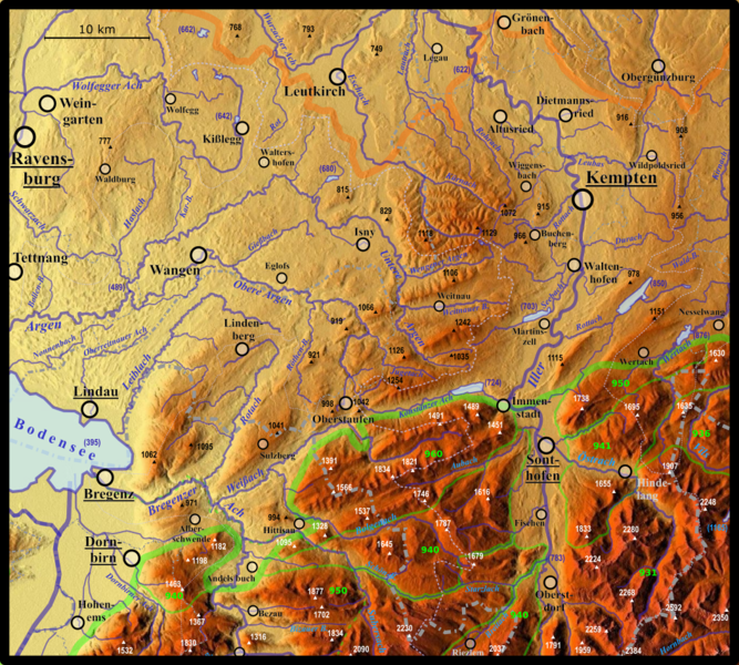
Deutsch: Relief der Nagelfluhschwelle mit den Nagelfluhhöhen und Senken zwischen Bodensee und Wertach und den Allgäuer Nagelfluh-Schichtkämmen.
VerwaltungsgrenzenDie Verwaltungsgrewnzen sind hierarchisch jeweils im Faktor 1,4 bzw. 0,7 zueinander strukturiert:
Städte und GemeindenKreisstädte und kreisfreie Städte in D sowie Bezirkshauptstädte in A und Kantonshauptstädte in CH sind unterstrichen. Die Gemeinden sind je nach Verdreifachung der Einwohnerzahlen im Faktor 1,25 bzw. 0,8 strukturiert, siehe z. B. an der Iller:
Die Einwohnerzahlen beziehen sich dabei auf geschlossene Besiedlungen, nicht auf nominelle Verwaltungsgemeinschaften. NaturräumeAlpenrandgrenze und alpine Haupt-Naturraumgrenzen nach Hansjörg Dongus 1991/1993 (Blätter 187 Lindau und 188 Kaufbeuren) in Grün; "landläufige" Gebirgsgruppengrenzen (AVE und SOIUSA), die von Naturraumgrenzen abweichen, sind gestrichelt eingezeichnet. Die grünen Zahlen stehen für (vgl. Naturräumliche Feingliederung nach Hormann und Dongus):
Die Nordgrenze des Subalpinen Jungmoränenlandes zu den Altmoränenlandschaften ist in Rot eingezeichnet. BerghöhenDie eingezeichneten Berghöhen sind die von (nach Höhe absteigend, nachgestellt Naturraumkennzahlen nach Dongus):
GewässerhöhenVon den Fließgewässern sind die wichtigsten beschriftet, die Standgewässer können über ihre Höhe über dem Meeresspiegel identifiziert werden. Ferner sind ein paar Mündungshöhen eingezeichnet:
WasserscheidenDie wichtigsten Wasserscheiden sind in Hellblau und gestrichelt eingezeichnet; sie sind jeweils im Faktor 1,4 bzw. 0,7 strukturiert:
|
| Date | |
| Source | Own work |
| Author | Elop, Relief: maps-for-free |
Licensing[edit]
- You are free:
- to share – to copy, distribute and transmit the work
- to remix – to adapt the work
- Under the following conditions:
- attribution – You must give appropriate credit, provide a link to the license, and indicate if changes were made. You may do so in any reasonable manner, but not in any way that suggests the licensor endorses you or your use.
- share alike – If you remix, transform, or build upon the material, you must distribute your contributions under the same or compatible license as the original.
File history
Click on a date/time to view the file as it appeared at that time.
| Date/Time | Thumbnail | Dimensions | User | Comment | |
|---|---|---|---|---|---|
| current | 10:31, 14 October 2019 | | 1,054 × 948 (2.01 MB) | Elop (talk | contribs) | paar Gewässerhöhen und Bachnamen, Bodensee beschriftet |
| 21:23, 13 October 2019 |  | 1,054 × 948 (2 MB) | Elop (talk | contribs) | Flüsse | |
| 10:07, 3 October 2019 |  | 1,054 × 948 (1.87 MB) | Elop (talk | contribs) | Bregenzer Ach, Bezirksgrenzen Österreich | |
| 20:42, 1 October 2019 |  | 1,054 × 948 (1.87 MB) | Elop (talk | contribs) | ||
| 23:02, 30 September 2019 |  | 1,054 × 948 (1.87 MB) | Elop (talk | contribs) | ||
| 14:30, 30 September 2019 |  | 1,054 × 948 (1.87 MB) | Elop (talk | contribs) | ||
| 23:07, 29 September 2019 |  | 1,054 × 948 (1.87 MB) | Elop (talk | contribs) | ||
| 19:53, 29 September 2019 |  | 1,054 × 948 (1.86 MB) | Elop (talk | contribs) | ||
| 22:49, 28 September 2019 |  | 1,054 × 948 (1.86 MB) | Elop (talk | contribs) | + Orte | |
| 13:39, 27 September 2019 |  | 1,054 × 948 (1.81 MB) | Elop (talk | contribs) |
You cannot overwrite this file.
File usage on Commons
The following 6 pages use this file:
File usage on other wikis
The following other wikis use this file: