File:Amtrak System Map.svg
跳至導覽
跳至搜尋

此 SVG 檔案的 PNG 預覽的大小:800 × 501 像素。 其他解析度:320 × 200 像素 | 640 × 400 像素 | 1,024 × 641 像素 | 1,280 × 801 像素 | 2,560 × 1,602 像素 | 1,042 × 652 像素。
原始檔案 (SVG 檔案,表面大小:1,042 × 652 像素,檔案大小:5.55 MB)
說明
說明
添加單行說明來描述出檔案所代表的內容
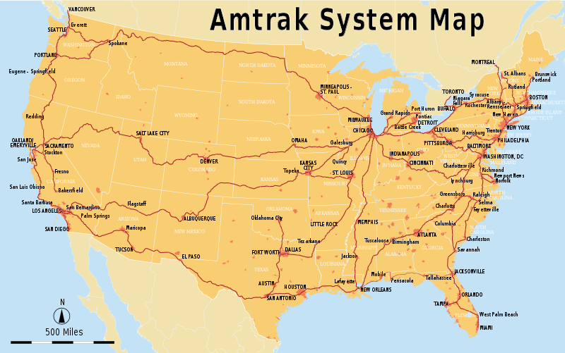
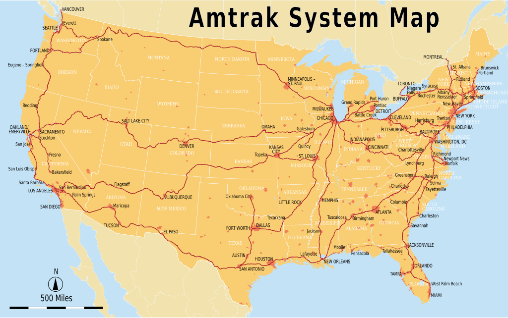
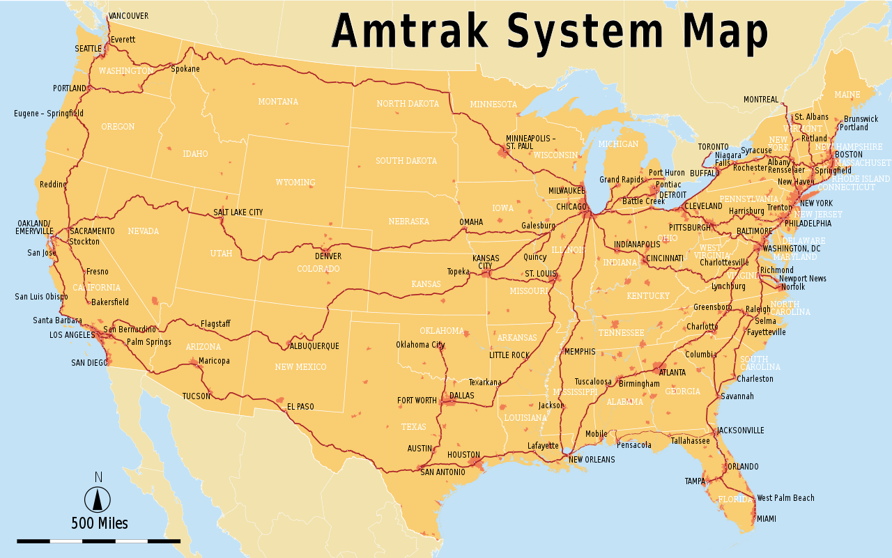
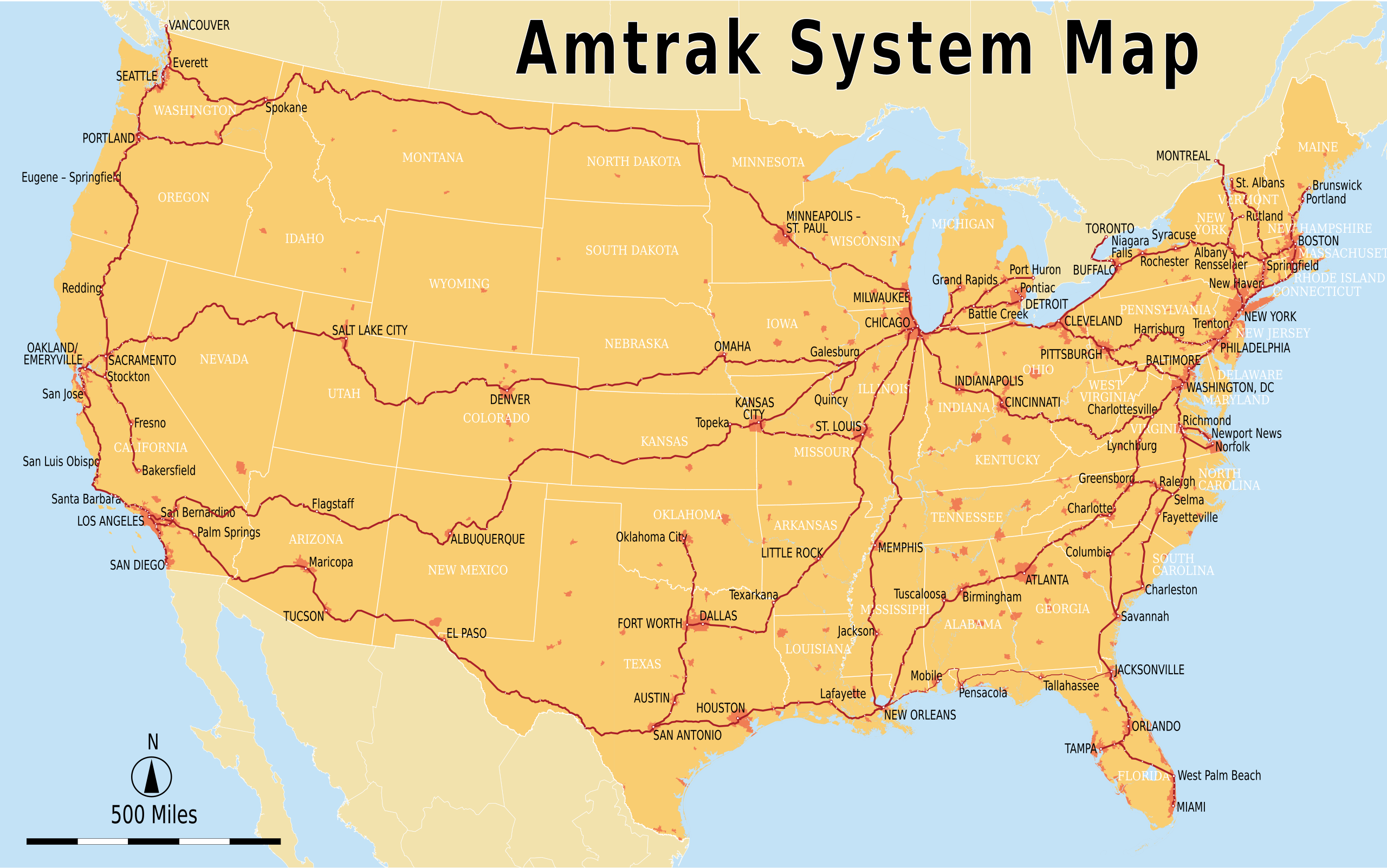
To-scale map of Amtrak services
| 描述 |
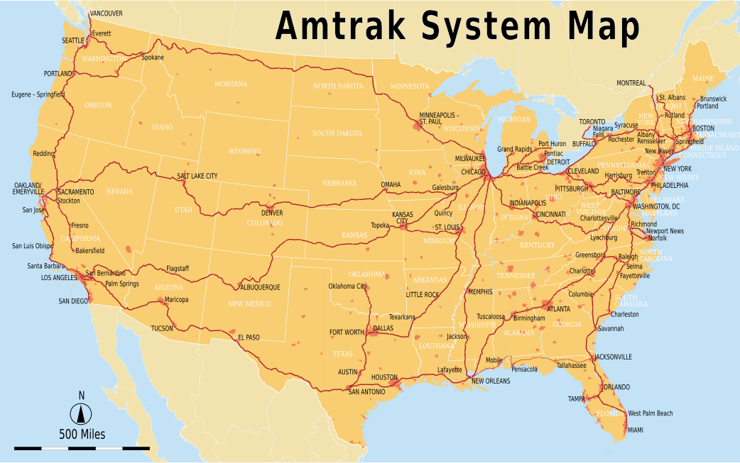
English: Geographically accurate Amtrak system map with major stations marked. The Sunset Limited section between New Orleans and Orlando is currently suspended. This map is accurate up to the Norfolk and Brunswick extensions of late 2012. |
| 日期 |
2011年9月4日 (original) 2013年5月26日 (most recent update) |
| 來源 | |
| 作者 |
Original uploader was Chumwa at de.wikipedia
|
| 其他版本 |
|

| 這是一張修飾過的圖片,即本圖片是用軟體修改過後的版本,修改的方式或內容有:Text to English and Imperial units。原版圖片來源:Amtrak-Streckennetz.svg。修改者:Pi.1415926535。
|
我,本作品的著作權持有者,決定用以下授權條款發佈本作品:
此檔案採用創用CC 姓名標示-相同方式分享 2.5 通用版授權條款。
- 您可以自由:
- 分享 – 複製、發佈和傳播本作品
- 重新修改 – 創作演繹作品
- 惟需遵照下列條件:
- 姓名標示 – 您必須指名出正確的製作者,和提供授權條款的連結,以及表示是否有對內容上做出變更。您可以用任何合理的方式來行動,但不得以任何方式表明授權條款是對您許可或是由您所使用。
- 相同方式分享 – 如果您利用本素材進行再混合、轉換或創作,您必須基於如同原先的相同或兼容的條款,來分布您的貢獻成品。
原始上傳日誌
[編輯]
This image is a derivative work of the following images:
- File:Amtrak-Streckennetz.svg licensed with Cc-by-sa-2.5
- 2011-03-15T01:13:20Z File Upload Bot (Magnus Manske) 1046x652 (4106470 Bytes) {{BotMoveToCommons|de.wikipedia|year={{subst:CURRENTYEAR}}|month={{subst:CURRENTMONTHNAME}}|day={{subst:CURRENTDAY}}}} {{Information |Description={{de|Amtrak-Streckennetz Sie dürfen das Bild zu den folgenden Bedingungen nut
Uploaded with derivativeFX
檔案歷史
點選日期/時間以檢視該時間的檔案版本。
| 日期/時間 | 縮圖 | 尺寸 | 使用者 | 備註 | |
|---|---|---|---|---|---|
| 目前 | 2013年5月26日 (日) 07:45 | | 1,042 × 652(5.55 MB) | Pi.1415926535(留言 | 貢獻) | Adding Norfolk and Brunswick extensions; missing stations |
| 2013年5月26日 (日) 06:21 |  | 1,042 × 652(5.54 MB) | Pi.1415926535(留言 | 貢獻) | Adding all stations, fixing a few geographical oddities, and moving text | |
| 2013年5月25日 (六) 18:52 |  | 1,046 × 652(5.42 MB) | Pi.1415926535(留言 | 貢獻) | Full grouping into layers for ease of access (no visual changes) | |
| 2012年10月18日 (四) 07:22 |  | 1,046 × 652(5.41 MB) | Pi.1415926535(留言 | 貢獻) | Starting to group into tabs; marking eastern section of Sunset Limited as suspended | |
| 2012年3月18日 (日) 17:33 |  | 1,046 × 652(4.12 MB) | Sebastian Wallroth(留言 | 貢獻) | replaced Adobe fonts with free fonts | |
| 2011年9月4日 (日) 23:43 |  | 1,046 × 652(4.63 MB) | Pi.1415926535(留言 | 貢獻) | {{Information |Description={{en|Amtrak system map}} |Source=*File:Amtrak-Streckennetz.svg |Date=2011-09-04 23:43 (UTC) |Author=*File:Amtrak-Streckennetz.svg: Maximilian Dörrbecker (Chumwa). Original upl |
無法覆蓋此檔案。
檔案用途
下列2個頁面有用到此檔案:
全域檔案使用狀況
以下其他 wiki 使用了這個檔案:
- cs.wikipedia.org 的使用狀況
- da.wikipedia.org 的使用狀況
- de.wikivoyage.org 的使用狀況
- en.wikipedia.org 的使用狀況
- en.wikivoyage.org 的使用狀況
- es.wikipedia.org 的使用狀況
- es.wikivoyage.org 的使用狀況
- fi.wikipedia.org 的使用狀況
- fr.wikipedia.org 的使用狀況
- hu.wikipedia.org 的使用狀況
- ko.wikipedia.org 的使用狀況
- ro.wikipedia.org 的使用狀況
- sl.wikipedia.org 的使用狀況
- sv.wikipedia.org 的使用狀況
- th.wikipedia.org 的使用狀況
- tr.wikipedia.org 的使用狀況
- wikimania2012.wikimedia.org 的使用狀況
- Washington, D.C./Transportation
- Washington, D.C./Transportation/en
- Washington, D.C./Transportation/es
- Washington, D.C./Transportation/diq
- Washington, D.C./Transportation/he
- Washington, D.C./Transportation/nl
- Washington, D.C./Transportation/zh-hant
- Washington, D.C./Transportation/az
- Washington, D.C./Transportation/pt-br
- Washington, D.C./Transportation/ka
- Washington, D.C./Transportation/mk
- Washington, D.C./Transportation/de
- Washington, D.C./Transportation/sk
- Washington, D.C./Transportation/pl
- Washington, D.C./Transportation/ar
- zh.wikipedia.org 的使用狀況