File:An accurate plan of the country between New York and Philadelphia - with the dispositions of the forces. LOC 2002620227.jpg
Jump to navigation
Jump to search

Size of this preview: 777 × 599 pixels. Other resolutions: 311 × 240 pixels | 623 × 480 pixels | 996 × 768 pixels | 1,280 × 987 pixels | 2,560 × 1,974 pixels | 3,707 × 2,859 pixels.
Original file (3,707 × 2,859 pixels, file size: 1.72 MB, MIME type: image/jpeg)
Captions
Captions
Add a one-line explanation of what this file represents
Summary[edit]
| Description |
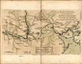
English: Shows positions of British (red) and American (blue) forces along the major highways between New York City and Philadelphia. Relief shown pictorially. At foot of title: Extracted from the Gazette of Tuesday, Feb'y 25th 1777. "Published as the Act directs March 3d 1777 by S. Pyle, Angel Court, Snow Hill--price 6d." Oriented with north toward the upper right. Includes distance table. Available also through the Library of Congress Web site as a raster image. LC copy halved along central fold line. Acquisitions control no.: 2001-7 |
||
| Title | An accurate plan of the country between New York and Philadelphia : with the dispositions of the forces. | ||
| Shelf ID | G3804.N4S3 1777 .P9 | ||
| Date | |||
| Source | https://www.loc.gov/item/2002620227/ | ||
| Author | Pyle, Stephen | ||
| Permission (Reusing this file) |
|
||
| Other versions |
|
||
| Location | New York Region · Philadelphia Region · New Jersey · United States · Pennsylvania · New York · New York (State) | ||
| Part of | Military Battles And Campaigns · American Memory · Catalog · Geography And Map Division · American Revolution And Its Era: Maps And Charts Of North America And The West Indies, 1750-1789 | ||
| Subject | United States · Revolution · Pennsylvania · New York Region · Philadelphia Region (Pa.) · New Jersey · Campaigns · Maps · Early Works To 1800 · Roads · New York Region (N.Y.) · Philadelphia Region · New York (State) · History |

Licensing[edit]
|
This is a faithful photographic reproduction of a two-dimensional, public domain work of art. The work of art itself is in the public domain for the following reason:
The official position taken by the Wikimedia Foundation is that "faithful reproductions of two-dimensional public domain works of art are public domain".
This photographic reproduction is therefore also considered to be in the public domain in the United States. In other jurisdictions, re-use of this content may be restricted; see Reuse of PD-Art photographs for details. | ||||
File history
Click on a date/time to view the file as it appeared at that time.
| Date/Time | Thumbnail | Dimensions | User | Comment | |
|---|---|---|---|---|---|
| current | 21:09, 17 May 2018 | | 3,707 × 2,859 (1.72 MB) | Fæ (talk | contribs) | LOC Maps https://www.loc.gov/item/2002620227/ #10398 |
You cannot overwrite this file.
File usage on Commons
The following page uses this file:
Categories:
- Maps in the Library of Congress
- 1777 maps of Pennsylvania
- Maps of the New York and New Jersey Campaign
- American Revolution in 1777
- 1777-02-25
- 1777 maps of New Jersey
- 1777 maps of New York (state)
- Delaware River in the 18th century
- Maps of the Delaware River
- Delaware River adjacent to New Jersey
- Old York Road (Philadelphia)
- 1777-03-03
- Sandy Hook (New Jersey)
- Coryell (surname)