File:An illustrated historical atlas map of Holt County, Mo. - carefully compiled from personal examinations and surveys. LOC 2010587339-34.jpg
Jump to navigation
Jump to search

Size of this preview: 494 × 599 pixels. Other resolutions: 198 × 240 pixels | 396 × 480 pixels | 633 × 768 pixels | 844 × 1,024 pixels | 1,688 × 2,048 pixels | 4,266 × 5,176 pixels.
Original file (4,266 × 5,176 pixels, file size: 4.99 MB, MIME type: image/jpeg)
Captions
Captions
Add a one-line explanation of what this file represents
Summary
[edit]| Description |
English: LeGear. Atlases of the United States, 5248 Includes index, brief history of Holt County, and brief biographies and portraits of early Holt County residents. Available also through the Library of Congress Web site as a raster image. Annotations in pencil on some maps. LC copy imperfect: Front and back boards separated from binding. Some foxing. Vendor: John Carbonell Acquisitions control no. 2010-054 |
||
| Title | An illustrated historical atlas map of Holt County, Mo. : carefully compiled from personal examinations and surveys. | ||
| Shelf ID | G1438.H6 B7 1877 | ||
| Parent | https://www.loc.gov/resource/g4163hm.gla00118/ | ||
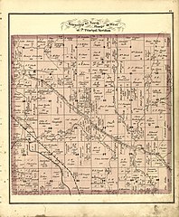
| Sheet title | Township 62 North Ranges 39 West of 5th Principal Meridian | ||
| Date | |||
| Source | https://www.loc.gov/item/2010587339/ | ||
| Author | Brink, Mcdonough & Co. | ||
| Permission (Reusing this file) |
|
||
| Other versions |
|
||
| Location | United States · Holt County · Missouri | ||
| Part of | American Memory · Catalog · County Landownership Maps · Geography And Map Division · Cultural Landscapes | ||
| Subject | United States · Holt County (Mo.) · Directories · Portraits · Maps · Missouri · Real Property · Holt County · Landowners · Biography · History |


Licensing
[edit]
|
This is a faithful photographic reproduction of a two-dimensional, public domain work of art. The work of art itself is in the public domain for the following reason:
The official position taken by the Wikimedia Foundation is that "faithful reproductions of two-dimensional public domain works of art are public domain".
This photographic reproduction is therefore also considered to be in the public domain in the United States. In other jurisdictions, re-use of this content may be restricted; see Reuse of PD-Art photographs for details. | ||||
File history
Click on a date/time to view the file as it appeared at that time.
| Date/Time | Thumbnail | Dimensions | User | Comment | |
|---|---|---|---|---|---|
| current | 07:02, 29 June 2018 | | 4,266 × 5,176 (4.99 MB) | Fæ (talk | contribs) | LOC Maps multisheet https://www.loc.gov/item/2010587339/ sheet 34 of 46 #18961 |
You cannot overwrite this file.
File usage on Commons
The following page uses this file: