File:Ancient balkans 4thcentury.png
Ir a la navegación
Ir a la búsqueda

Tamaño de esta previsualización: 790 × 600 píxeles. Otras resoluciones: 316 × 240 píxeles | 632 × 480 píxeles | 1012 × 768 píxeles | 1113 × 845 píxeles.
Archivo original (1113 × 845 píxeles; tamaño de archivo: 88 kB; tipo MIME: image/png)
Leyendas
Leyendas
Añade una explicación corta acerca de lo que representa este archivo
| Descripción |
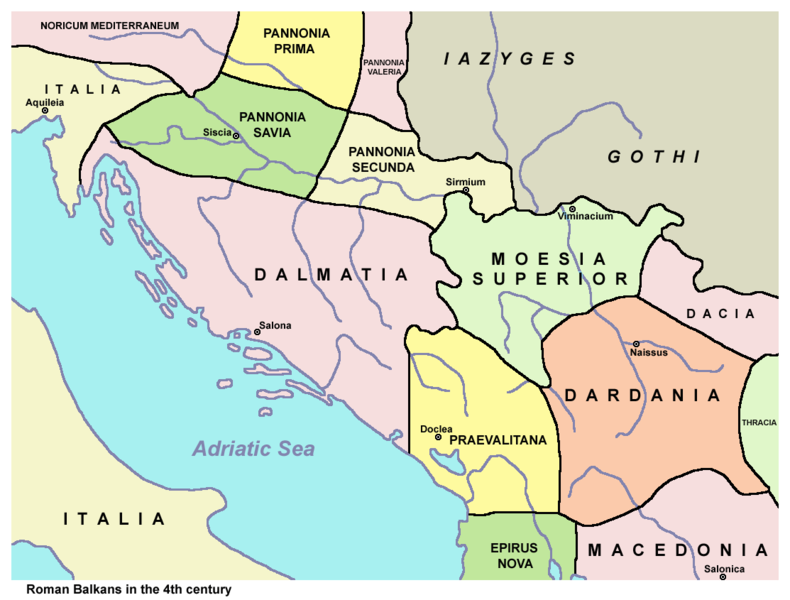
English: Ancient Roman Balkans in the 4th century. Српски / srpski: Antički rimski Balkan u 4. veku. |
| Fecha | |
| Fuente | Trabajo propio. Based on data from published sources and web sources. See References below. |
| Autor | PANONIAN |
| Otras versiones |
[]
|


Licencia[editar]
| Este trabajo ha sido liberado al dominio público por su autor, PANONIAN de Wikipedia en inglés. Esto aplica para todo el mundo. En algunos países esto puede no ser legalmente factible; si ello ocurriese: PANONIAN otorga a cualquier persona el derecho de usar este trabajo para cualquier propósito, sin ningún tipo de condición, a menos que éstas sean requeridas por la ley. |
References[editar]
- Sima M. Ćirković, Srbi među evropskim narodima, Beograd, 2004.
- Denis Šehić - Demir Šehić, Istorijski atlas Sveta, Beograd, 2007.
- http://www.euratlas.net/history/europe/300/europe_map_0300.html
- http://xxlworld.xx.ohost.de/povijest/slike/mape/3-5cen.jpg[dead link]
- http://www.geocities.ws/lajme8reja/1111111111dardania.JPG
- http://www.orbilat.com/Maps/Latin/Balkan_Latin.gif
- http://soltdm.com/geo/arts/delta/hierocl.jpg
Registro original de carga[editar]
Aquí se muestra la página de descripción original. Los siguientes nombres de usuario se refieren a en.wikipedia.
Historial del archivo
Haz clic sobre una fecha y hora para ver el archivo tal como apareció en ese momento.
| Fecha y hora | Miniatura | Dimensiones | Usuario | Comentario | |
|---|---|---|---|---|---|
| actual | 21:40 25 nov 2013 | | 1113 × 845 (88 kB) | PANONIAN (discusión | contribs.) | aesthetics |
| 11:34 8 abr 2010 |  | 1115 × 845 (88 kB) | PANONIAN (discusión | contribs.) | Reverted to version as of 11:22, 8 April 2010 - fixing thumbnail problem | |
| 11:32 8 abr 2010 |  | 1115 × 845 (89 kB) | PANONIAN (discusión | contribs.) | Reverted to version as of 00:04, 7 March 2010 - fixing thumbnail problem | |
| 11:22 8 abr 2010 |  | 1115 × 845 (88 kB) | PANONIAN (discusión | contribs.) | correction | |
| 00:04 7 mar 2010 |  | 1115 × 845 (89 kB) | PANONIAN (discusión | contribs.) | corrected mistake | |
| 23:24 6 mar 2010 |  | 1115 × 845 (89 kB) | PANONIAN (discusión | contribs.) | improved version | |
| 13:01 4 sep 2009 |  | 1300 × 943 (113 kB) | Penn Station (discusión | contribs.) | {{Information |Description=Own work by authors(PANONIAN, Olahus). Ancient balkans 4thcentury. |Source=File:Ancient balkans 4thcentury.png |Date=19:53, 7 March 2008 |Author=PANONIAN, Olahus |Permission= |other_versions= }} {{PD-user-en|PANONIAN, Olahus}} |
No puedes sobrescribir este archivo.
Usos del archivo
Las siguientes páginas usan este archivo:
- Atlas of Albania
- Atlas of Bosnia and Herzegovina
- Atlas of Croatia
- Atlas of Kosovo
- Atlas of Montenegro
- Atlas of Republika Srpska
- Atlas of Serbia
- Atlas of Vojvodina
- Illyria and Illyrians
- User:Penn Station
- File:Ancient balkans 4thcentury-es.svg
- File:Ancient balkans 4thcentury-sr.png
- File:Ancient balkans 4thcentury-zh.svg
- File:Ancient balkans 4thcentury.png
- Template:Other versions/Ancient balkans 4thcentury
Uso global del archivo
Las wikis siguientes utilizan este archivo:
- Uso en an.wikipedia.org
- Uso en ar.wikipedia.org
- Uso en azb.wikipedia.org
- Uso en az.wikipedia.org
- Uso en be.wikipedia.org
- Uso en bg.wikipedia.org
- Uso en bn.wikipedia.org
- Uso en br.wikipedia.org
- Uso en bs.wikipedia.org
- Uso en ca.wikipedia.org
- Uso en cs.wikipedia.org
- Uso en de.wikipedia.org
- Uso en el.wikipedia.org
- Uso en en.wikipedia.org
Ver más uso global de este archivo.
Categorías:
- Maps of the history of the ancient Balkans
- Maps of the history of Croatia in ancient times
- Maps of the history of Dalmatia
- Maps of the history of Slavonia
- Maps of the history of Bosnia and Herzegovina in ancient times
- Maps of the history of Montenegro in ancient times
- Maps of the history of Serbia in ancient times
- Maps of the history of Vojvodina
- Maps of the history of Syrmia
- Maps of the history of Kosovo in ancient times
- Maps of the history of Albania in ancient times
- Maps of the history of North Macedonia in ancient times
- Roman provinces (Balkans)
- Maps of Illyricum
- Maps of Roman Dalmatia
- Maps of Roman Praevalitana
- Maps of Roman Pannonia
- Moesia Prima
- Dardania (Roman Empire)
- Dacia Aureliana
- Maps of the Goths
- Iazyges
- Liburnians